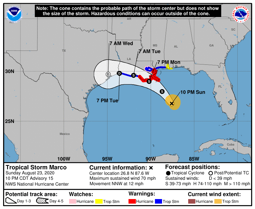
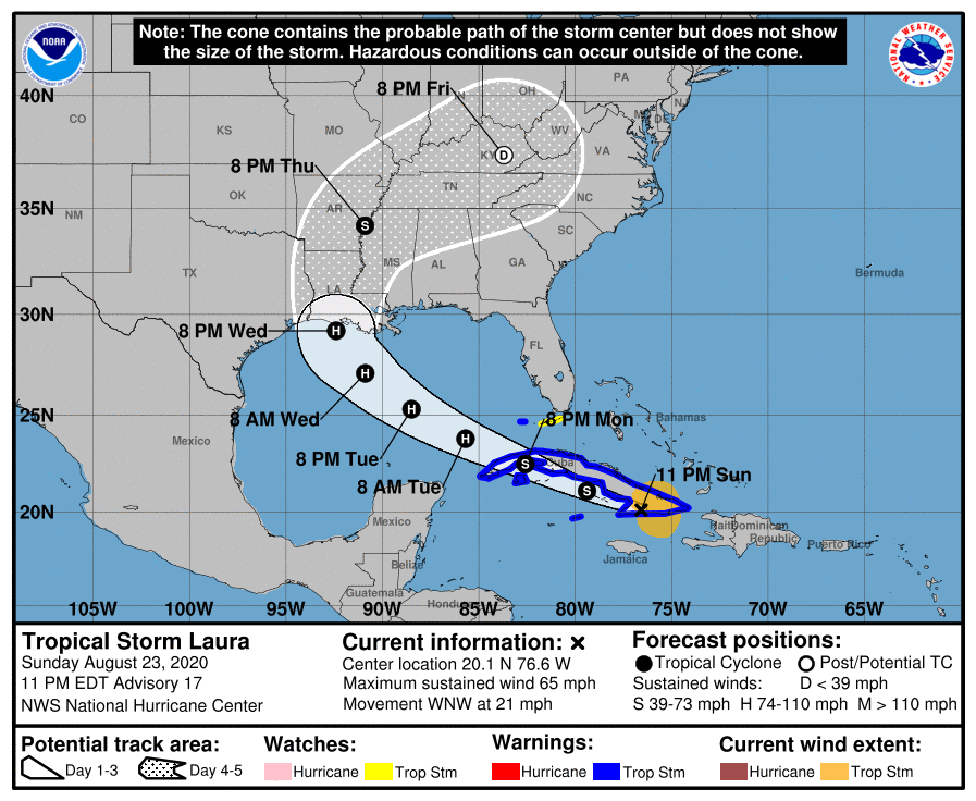
Only last week we were following power cuts caused by both a heat wave in California and hurricane force winds in Ireland thanks to the extratropical cyclone dubbed Storm Ellen by Met Éireann. This week we already have two hurricanes heading for the United States coast in the Gulf of Mexico, where a significant storm surge and numerous power outages are now expected.
The sustained wind speeds of Hurricane Marco have just dropped below the Saffir-Simpson scale category 1 threshold of 74 miles per hour. However storm surge and hurricane warnings are still in place for the Gulf coast of Lousiana:

A STORM SURGE WARNING IS IN EFFECT FOR....
* MORGAN CITY LOUISIANA TO OCEAN SPRINGS MISSISSIPPI
* LAKE BORGNE
A HURRICANE WARNING IS IN EFFECT FOR...
* MORGAN CITY LOUISIANA TO THE MOUTH OF THE PEARL RIVER
Marco is due to make landfall later this evening. Meanwhile Tropical Storm Laura, currently crossing Cuba, is forecast to strengthen as she crosses the Gulf before making landfall at hurricane strength on Wednesday night, in Louisiana once again:

FORECAST VALID 27/0000Z 29.2N  92.4W
MAX WIND  90 KT...GUSTS 110 KT.
50 KT... 50NE  40SE  30SW  40NW.
34 KT...100NE 100SE  50SW  80NW.
Significant damage to the electricity distribution infrastructure in the southern USA is expected. Yet again we are compelled to wonder if many of the anticipated power outages could have been prevented if areas of the United States vulnerable to hurricane damage already possed significant numbers of vehicle-to-grid capable electric vehicles and bidirectional charging stations?
Here’s an image of Hurricane Laura over the Gulf of Mexico, recorded a few minutes ago by the GOES-16 satellite:

Laura has made landfall as a major category 4 hurricane. According to the most recent National Hurricane Center public advisory notice:
100 AM CDT Thu Aug 27 2020
...EXTREMELY DANGEROUS CATEGORY 4 HURRICANE LAURA MAKES LANDFALL NEAR CAMERON LOUISIANA...
...CATASTROPHIC STORM SURGE, EXTREME WINDS, AND FLASH FLOODING OCCURRING IN PORTIONS OF LOUISIANA...
SUMMARY OF 100 AM CDT...0600 UTC...INFORMATION
----------------------------------------------
LOCATION...29.8N 93.3W
ABOUT 30 MI...45 KM SSW OF LAKE CHARLES LOUISIANA
ABOUT 40 MI...70 KM E OF PORT ARTHUR TEXAS
MAXIMUM SUSTAINED WINDS...150 MPH...240 KM/H
PRESENT MOVEMENT...N OR 350 DEGREES AT 15 MPH...24 KM/H
MINIMUM CENTRAL PRESSURE...938 MB...27.70 INCHES
Here’s how Laura looked from the GOES-East satellite:

and here are the side effects of her passage on the local electricity distribution grids in Louisiana and Texas:


There are now well over half a million premises across Louisina and Texas suffering from a power cut due to Hurricane Laura. Here are the outage maps from poweroutage.us:


Plus Entergy‘s map of the current state of their distribution grid in southern Louisiana:

Repeating a message I imparted on Twitter earlier this morning:
As #HurricaneLaura reduces in intensity heading north over land, there are currently almost 800,000 properties across #Louisiana, #Texas and #Arkansas enduring a #PowerOutage.
Widespread adoption of #V2G capable #ElectricVehicles could help reduce that problem in future. pic.twitter.com/nJ0IstCGTt
— V2G Limited (@V2gUK) August 28, 2020
According to PowerOutage.us there are still over half a million properties suffering from a power cut this morning in the aftermath of Hurricane Laura:


Marco is still due to make landfall as a mere tropical storm later today:
FORECAST POSITIONS AND MAX WINDSINIT 24/1500Z 28.5N 88.5W 45 KT 50 MPH
12H 25/0000Z 29.2N 89.3W 35 KT 40 MPH...INLAND
24H 25/1200Z 30.0N 91.3W 30 KT 35 MPH...POST-TROP/REMNT LOW
36H 26/0000Z 30.5N 93.6W 30 KT 35 MPH...POST-TROP/REMNT LOW
48H 26/1200Z 30.9N 95.9W 25 KT 30 MPH...POST-TROP/REMNT LOW
60H 27/0000Z...DISSIPATED
Different models are making different predictions regarding Laura, but here’s what the National Hurricane Centers’s 15Z discussion has to say on the matter:
Key Messages:1. Tropical storm conditions are expected across much of Cuba today. Heavy rainfall is likely across Cuba and Jamaica today, and these rains could cause mudslides and life-threatening flash and urban flooding. Tropical storm conditions are expected in the Dry Tortugas, and the Middle and Lower Florida Keys later today.
2. There is an increasing risk of dangerous storm surge, wind, and rainfall impacts from the upper Texas coast through the north-central Gulf Coast beginning on Wednesday. Interests in these areas should monitor the progress of Laura and ensure they have their hurricane plan in place, as storm surge and hurricane watches will likely be issued later today.
FORECAST POSITIONS AND MAX WINDS
INIT 24/1500Z 21.2N 80.6W 50 KT 60 MPH
12H 25/0000Z 22.2N 82.9W 55 KT 65 MPH
24H 25/1200Z 23.6N 86.0W 60 KT 70 MPH
36H 26/0000Z 25.2N 88.8W 70 KT 80 MPH
48H 26/1200Z 26.8N 91.1W 80 KT 90 MPH
60H 27/0000Z 28.7N 92.8W 90 KT 105 MPH
72H 27/1200Z 31.2N 93.3W 65 KT 75 MPH...INLAND
96H 28/1200Z 36.0N 90.9W 30 KT 35 MPH...INLAND
120H 29/1200Z 37.5N 81.0W 25 KT 30 MPH...POST-TROP/REMNT LOW
Marco is making landfall right around now, at barely tropical storm force:
Laura on the other hand is currently forecast to be a strong, and possibly major, hurricane at landfall on Wednesday night/Thursday morning:
Marco had faded away by the time he reached the Louisiana coast, but Laura is forecast to do the reverse. The latest NHC guidance shows her achieving “major hurricane” status before landfall:
Post Laura power cuts are back below 500,000 this morning:
Plus moving pictures of the lights going out in Louisiana
Power outages in Louisiana are gradually reducing, but this morning (UTC) there are still over 300,000 remaining to be repaired:
At long last power outages in Louisiana have dropped below 100,000:
However as you can see, the fires are still burning on the west coast of the United States.