As we anticipated yesterday, Storm Barra has been officially named by Met Éireann even though the remaining power cuts due to Storm Arwen have yet to be repaired:
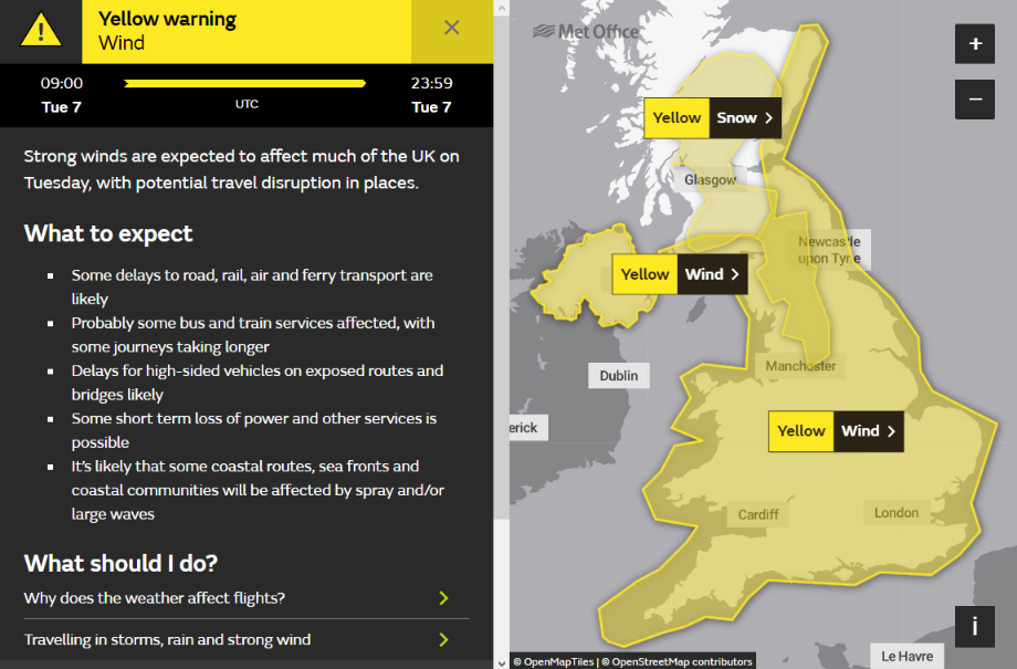
Here is the Met Office’s current high wind warning for Tuesday:

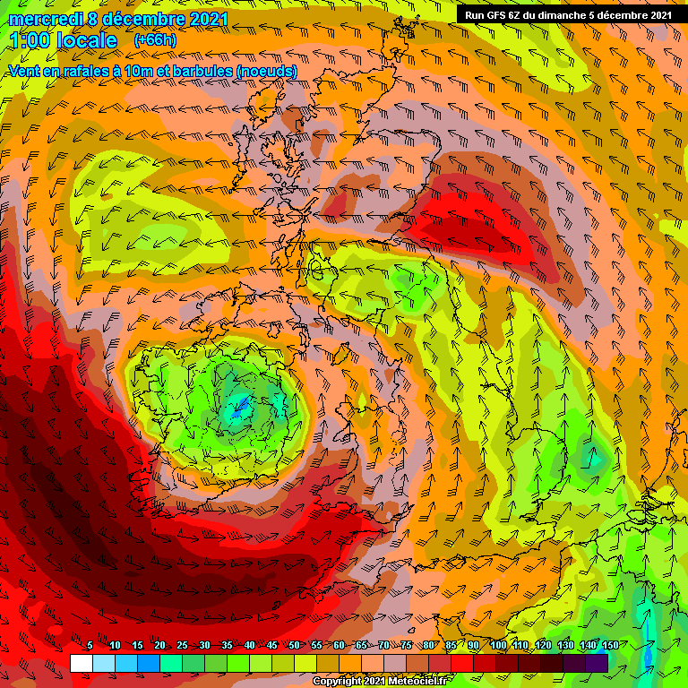
and here is the current GFS wind gust forecast for early Wednesday morning:

We anticipate more power cuts across Ireland as well as here in Cornwall and further afield across the United Kingdom.
Here is ESB Networks’ view of the calm before Storm Barra:

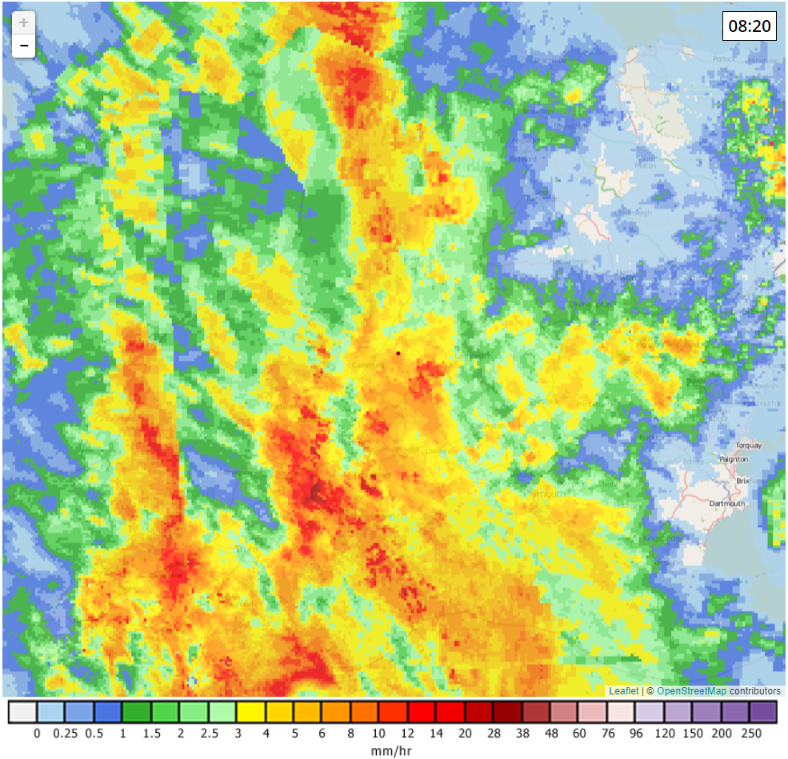
The rain from Storm Barra has recently arrived here in South West England:

Meanwhile the strongest gusts of wind are arriving in South West Ireland:

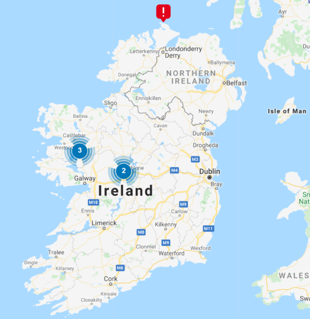
Here is the current Electricity Supply Board power cut map for Ireland:

The distribution grid in Eire has borne the brunt of Storm Barra’s destruction thus far today:

However Northern Ireland is suffering as well:

On the mainland a few power cuts are also popping up in SSEN’s southern region:

SPEN’s power cut map for their ManWeb region currently includes lots of outages that have already been repaired, but the list view reveals several new ones as well. This is page 6, with 10 incidents per page:

Here is a satellite image of Storm Barra earlier this afternoon:

Here too is this evening’s selection of Storm Barra power cut maps:


Eire has suffered the majority of the power cuts caused by Storm Barra so far, so let’s start this morning’s overview with the ESB map:

Northern Ireland Electricity Networks have managed to repair their initial faults:

The Scottish Power maps include already repaired faults, and so are somewhat misleading:

However viewing current faults in a list reveals several recent ones awaiting repair. This is page 10:

Further north SSEN’s network has suffered much less damage than during Storm Arwen:

WPD, UKPN and SSEN’s southern network have no lingering faults from Storm Barra, but the same cannot be said for Northern Powergrid:

Viewing their power outages in a list reveals several still outstanding that date back to Storm Arwen:

Finally, for the moment at least, here is the Met Office’s Euro 4 surface wind gust forecast earlier today:

Earlier today ESB Networks reported that they had “8,000 customers who remain without power “.
Here is their current power cut map, but note that the “clusters” don’t distinguish between current power cuts and recently repaired faults:

Here too is the current Northern Powergrid power cut map, which does distinguish between current power cuts and recently repaired faults:

They appear to still have a couple of unrepaired power outages dating back to the passage of Storm Arwen:

ESB Networks haven’t issued a further statement regarding the last few post Storm Barra power cuts that still needed repairing overnight. However their power cut map is looking a lot better today:

Remember that the “clusters” include recently repaired faults as well as existing ones.
[Edit – December 11th]Finally all the assorted power cut maps have returned to something approaching normality:


However more strong winds are forecast. Overnight for northwest Scotland, and then this in the Met Office Euro4 surface wind gust forecast for Sunday evening:

Watch this space!

The latest update on Storm Barra from Met Éireann via Twitter:
https://twitter.com/MetEireann/status/1467516389602828288
The Energy Networks Association are expecting to have work to do when Storm Barra arrives on Tuesday:
The BBC have spotted the potential problem:
The current UK Met Office synopsis shows the future Storm Barra as an innocuous looking 1019 hPa MSLP low in the bottom left of the chart:
However all the models agree he will look much more worrisome in 36 hours or so:
The Met Office have extended their Storm Barra high wind warning into Wednesday for South West England and Northern Ireland:
In their 2 PM report on preparations for the arrival of Storm Barra tomorrow Western Power Distribution report that:
In their first Storm Barra Adverse Weather Warning at 2:30 PM today Scottish Power Energy Networks state that:
Met Éireann has issued a red warning for tomorrow:
Scottish and Southern Electricity Networks have issued their first weather warning for Storm Barra, on this occasion for their southern network:
In a news release earlier today UK Power Networks announced that:
Here’s the latest wind gust forecast for tomorrow evening:
The Met Office’s synoptic chart for noon today:
and their latest rain forecast:
Our 10:15 Storm Barra power cut map update on Tuesday:
In their 10 AM Storm Barra update ESB Networks report that:
The latest Storm Barra update from the UK Met Office:
In their 12:30 PM Storm Barra update NIE Networks report that:
In their 12:45 PM Storm Barra update ESB Networks state that:
The Met Office has just extended its severe wind warning for tomorrow to include North West Wales:
https://twitter.com/metoffice/status/1468244813397082123
The Energy Networks Association has just posted a Twitter thread about their members’ preparations for Storm Barra:
https://twitter.com/energynetworks/status/1468247807706509312
Tuesday evening’s Storm Barra update from the Met Office:
The Met Office’s maximum wind gust update:
https://twitter.com/metoffice/status/1468302621970685952
In their 8:45 PM Storm Barra update ESB Networks report that:
Our late night Storm Barra power cut map update on Twitter:
The Met Office’s latest overview of Storm Barra. It seems North Cornwall was the place to be, temperature wise at least:
https://twitter.com/metoffice/status/1468373610050080771
Today’s Independent front page:
“Weather bomb Barra blasts Britain”
SSEN report that:
In their 12:45 PM Storm Barra update on Wednesday ESB Networks report that:
The latest Met Office Storm Barra maximum gust speed update. Now including Berry Head:
https://twitter.com/metoffice/status/1468603853419466758
Met Éireann wave bye bye to Storm Barra:
https://twitter.com/MetEireann/status/1468614627030355974
In their 5 PM Storm Barra update ESB Networks state that:
In their 8:30 PM Storm Barra update ESB Networks report that:
In their 21:15 PM Storm Barra update on Wednesday SPEN report that:
ESB Networks Thursday morning Storm Barra update via Twitter:
In their latest Storm Barra Twitter update ESB Networks report that they still have 3,000 properties with power outages in need of repair: