Storm Otto Blacks Out Scotland

Yesterday morning the United Kingdom’s Met Office issued a press release about the impending arrival of a disruptive weather system:

A low-pressure system which will bring high winds and rain to parts of the UK has been named Storm Otto by the Danish Meteorological Institute (DMI).

Storm Otto will move east across the far north of the UK from the early hours of Friday morning, likely bringing gusts in excess of 75mph to some northern areas.

Met Office Chief Meteorologist Andy Page said: “Storm Otto will bring high winds and rain to the UK, with some northern parts of Scotland and the northeast of England likely to get the strongest gusts of wind, possibly in excess of 75mph. Warnings have been issued and could be updated as Storm Otto develops.

“There’s a chance of travel disruption and high-sided vehicles could be particularly prone to disrupted plans in this set-up. There’s associated rain with Storm Otto, with 40-50 mm of rain likely to fall over parts of western Scotland.”

Potential impacts highlighted in the warning also the likelihood of large waves, especially in North Sea coasts, as well as a chance of some damage to buildings and infrastructure.

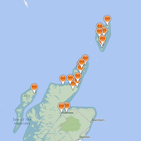
This was accompanied by a weather warning for high winds from Storm Otto:

Continue reading →

Storm Franklin Power Cuts

There are still numerous faults across South West England caused by Storm Eunice last Friday that haven’t been repaired yet. Now a lot more power cuts have been added to the long lists of UK DNOs thanks to the arrival across the British Isles of yet another named storm yesterday, Storm Franklin. Here’s how the Met Office initially announced the news:


Storm Franklin has been named as the low-pressure system is expected to bring high winds during Sunday night and into Monday morning for much of the UK.

The latest storm follows on from a week in which Storm Dudley and Storm Eunice also impacted the UK, although wind gusts from Storm Franklin are expected to be lower than Eunice which triggered two Red Weather Warnings.

Northern areas of Northern Ireland are covered by an Amber Wind Warning that will be in force from early Monday morning. Within the Amber Warning area, winds could be in excess of 80mph in exposed coastal areas, but more widely between 60 and 70mph. Damage to buildings is possible, and there’s likely travel disruption.


An extended Yellow Warning for wind which covers much of the rest of the UK, except the northeast, has also been issued for Storm Franklin. Within the yellow warning area, wind gusts will be 65-75mph in coastal areas, and more widely 50-60mph further inland. The coasts of the northwest of England and the southwest of Scotland could see gusts of up to 75mph for a short period on Sunday night and early Monday morning.

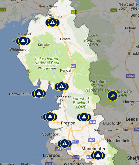
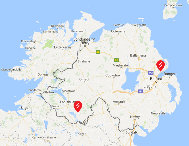
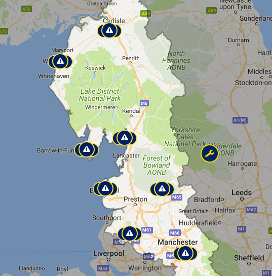
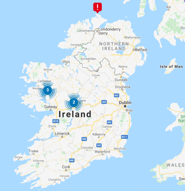
Here are the by now all too familiar live power cut maps from across the British Isles this morning, starting with the island of Ireland:

Continue reading →

Storm Eunice Wreaks Havoc

Regular readers may recall our own recent power cut in the wake of Storm Arwen before Christmas? Whether we experience another one tomorrow remains to be seen, but I am confident that many other people down here in South West England will.

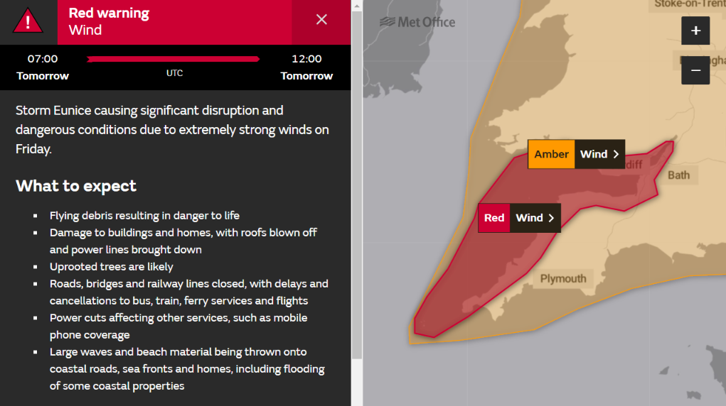
The Met Office issued a rare “red” wind warning for our part of the world earlier today:

The Met Office forecasts that:

Extremely strong west to southwesterly winds will develop over southwest England and south Wales early on Friday. Widespread inland gusts of 70-80 mph are likely and up to around 90 mph near some coasts, with dangerous conditions on beaches and seafronts. Winds are expected to ease from the west during the late morning.

What to expect

  • Flying debris resulting in danger to life
  • Damage to buildings and homes, with roofs blown off and power lines brought down
  • Uprooted trees are likely
  • Roads, bridges and railway lines closed, with delays and cancellations to bus, train, ferry services and flights
  • Power cuts affecting other services, such as mobile phone coverage
  • Large waves and beach material being thrown onto coastal roads, sea fronts and homes, including flooding of some coastal properties

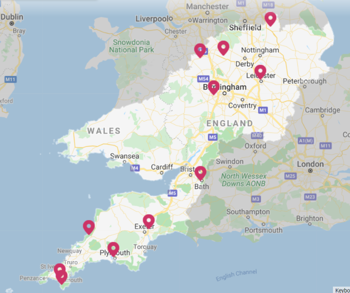
In the aftermath of Storm Dudley here are the current power cut maps for Western Power Distribution:

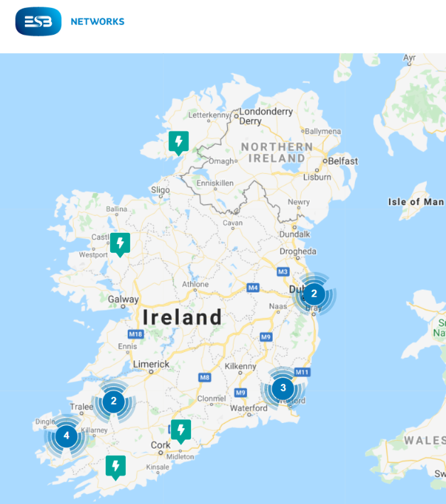
and ESB Networks:

I cannot help but wonder what they will look like by noon tomorrow?

[Edit – 13:00 on February 18th]

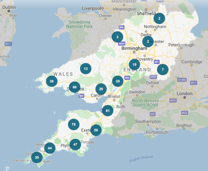
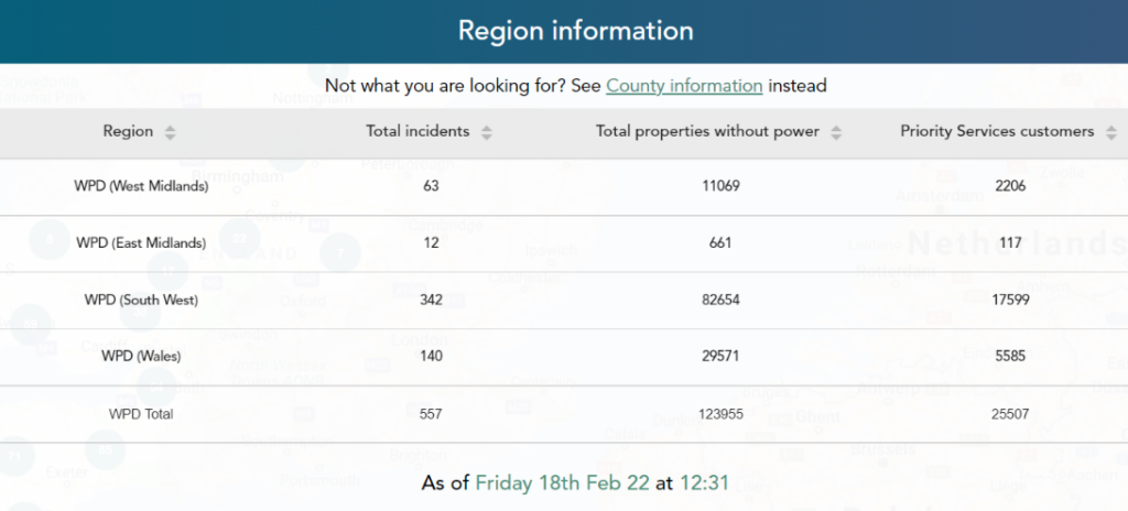
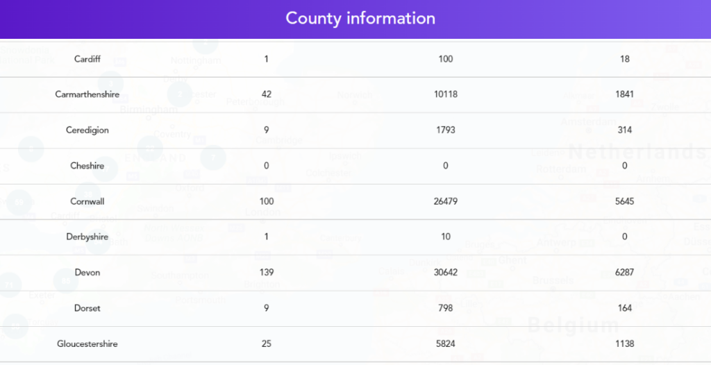
In a slightly belated answer to the question I posed last night, here are WPD’s current map and tables of woe:

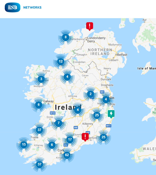
Together with ESB Networks map for Eire:

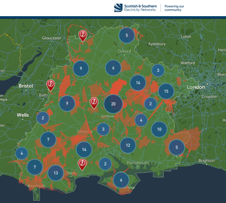
Plus Scottish and Southern’s south coast map:

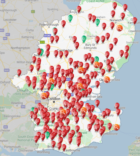
plus UK Power Networks’ map for South East England:

The other DNOs don’t provide handy tables of real time outage numbers, but WPD’s reveal that at 12:40 there were 123,955 properties without electric power across their four regions of the UK, of which 26,479 are here in Cornwall with another 30,642 next door in Devon.

Storm Franklin arrived on our shores before all the faults caused by Storm Eunice were repaired. Hence the story continues over at:

“Storm Franklin Power Cuts“


Storm Barra Barrels Towards Britain

As we anticipated yesterday, Storm Barra has been officially named by Met Éireann even though the remaining power cuts due to Storm Arwen have yet to be repaired:

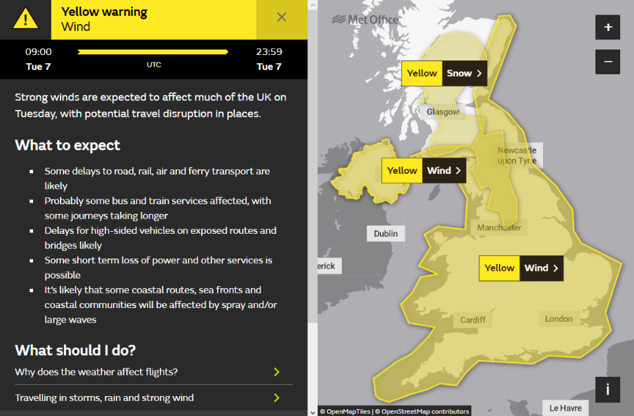
Here is the Met Office’s current high wind warning for Tuesday:

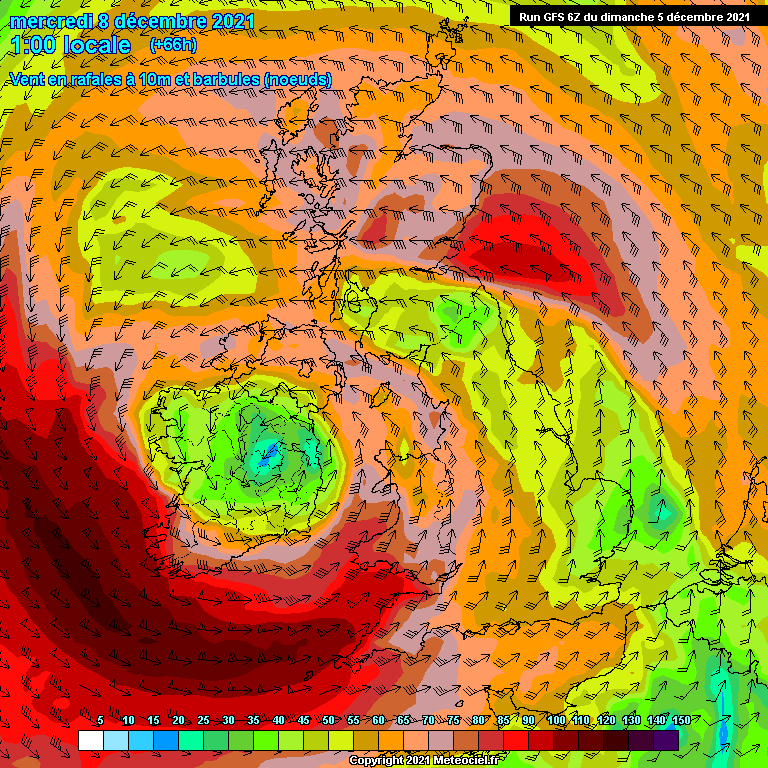
and here is the current GFS wind gust forecast for early Wednesday morning:

We anticipate more power cuts across Ireland as well as here in Cornwall and further afield across the United Kingdom.

Here is ESB Networks’ view of the calm before Storm Barra:

[Edit – December 7th 09:00]

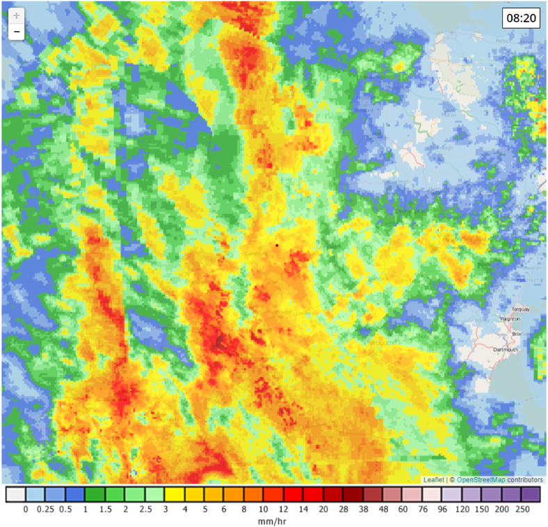
The rain from Storm Barra has recently arrived here in South West England:

Continue reading →

Storm Arwen Blacks Out Scotland

The United Kingdom’s Meteorological Office has officially named the first severe storm of the winter of 2021/22:

As you can see from the forecast above, very strong winds are forecast to hit the north east coast of Scotland later today, which will inevitably lead to a large number of power cuts.

The UK Met Office has now also issued a red weather warning for Storm Arwen:

https://twitter.com/metoffice/status/1464187971230482443

[Edit – November 26th 22:00]

High winds speeds in Scotland have been expected, but the coast of South Devon has also been subject to gusts over 60 mph:

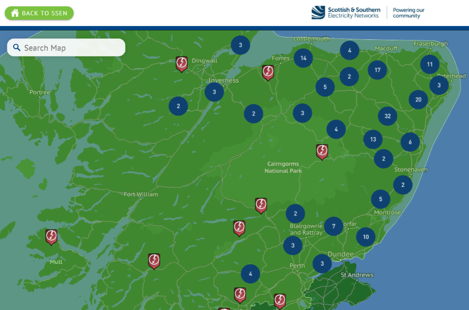
Here’s the latest power cut map for the north of Scotland from Scottish and Southern Electricity, showing a total of 201 “unplanned outages”:

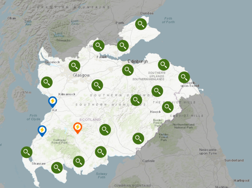
and here is Scottish Power’s map for further south:

Continue reading →

V2G meets Project LEO at COP26

I remotely attended several sessions at the recently completed COP26 conference in Glasgow, but what with one thing and another I missed out on attending this one as it happened:

As you can already see it was organised by Scottish and Southern Electricity Networks (SSEN for short) and was hosted by Laura Sandys. Note in particular the part at 6:30 where Professor Malcolm McCulloch of Oxford University says that:

So the challenge is to say “How do we allow that potential problem and risk, how do we turn that around to be something that’s really a friend and an aid to the system?”

And the one thing that worries me right at the moment is that we’re seeing a huge uptake in electric vehicles over the last while, I mean it’s kind of fascinating that at the beginning of this year the most popular vehicle being sold was the Ford Focus, last three months it’s been the Tesla Model 3! That kinds of tells you what the change in our dynamics is looking at.

At the moment we’re missing a trick because most of the vehicles being sold except for a few Nissan’s and a few others don’t have vehicle-to-grid. In other words the power flows in only one direction, so all that huge amount of storage capacity that’s available on the grid, we’re talking about by the time we get to 2030 there’s enough energy in the batteries of our electric vehicles to power the UK for two days. That’s a tremendous amount of energy that’s sitting there, but if we don’t install V2G soon, really soon, that boat is going to pass and we’re going to have real trouble in trying to, or much more costly ways of doing that.

Needless to say we broadly agree with Malcolm’s analysis, and the conversation in Glasgow continued. Please watch the whole 30+ minutes, but now there is further news. The Local Energy Oxfordshire project (LEO for short) has just released a white paper authored by Origami Energy and the Low Carbon Hub catchily entitled “Vision on the inclusion of small (under 7kW) flexibility from the grid edge and its role in Future Energy System“. Please also read it from cover to cover, and note that it briefly (and belatedly!) mentions that:

In 2021, British Standards Institute as part of [its] Smart Energy Appliance programme published two standards designed to support [a] testing and certification programme to motivate greater potential for demand response from [the] residential sector.

Note also LEO’s recommendations:

Grid-edge flexibility has great potential to be the enabler of Net Zero as outlined by the “Leading the Way” FES scenario. However, t he two biggest challenges facing the inclusion of small flexibility from the grid edge into delivering Net Zero are societal participation and commercial environment. A common pillar to both challenges is the value of flexibility which only partially reflects the benefits delivered through the flexibility markets. Today, each flexibility market is monopsonistic (market dominated by one buyer), segregated and short-term (there is a lack of long term stability in the regulatory landscape). There is a need to standardise products and services across all flexibility markets to encourage greater transparency and involvement of flexibility as these flexibility markets grow.

To support the inclusion of grid-edge flexibility, the proposed recommendations include:

• To tailor the legislation and regulation to support the development of local communities who act collectively to manage their LCTs and interact with the flexibility markets and other users of the system at a single node (e.g. enabled by an iDNO) or multiple nodes.

• Create a new energy and carbon marketplace to encourage wider deployment of Smart Local Energy Systems where local generation and demand flexibility is recognised as being critical for a healthy and affluent society. The Flexible Services players are seen to add significant benefit to the local society and also provide support to the National scale economy.

• Align the energy policy, welfare policy and housing policy to deliver long-term strategy for Net Zero and beyond ensuring balanced distribution of costs and benefits associated with grid-edge flexibility and cost of energy.


Storm Caroline Power Cuts

Yesterday the UK Met Office issued an amber warning for strong winds caused by Caroline, the third named storm of the winter in this part of the world:

With up to 90 mph gusts expected in the north of Scotland the Met Office pointed out that:

Flying debris is likely and could lead to injuries or danger to life. Some damage to buildings is possible, such as tiles blowing off roofs. Longer journey times and cancellations are likely, as road, rail, air and ferry services may be affected. There is a good chance that power cuts may also occur. Large waves are expected and beach material may be thrown onto coastal roads, sea fronts and properties.

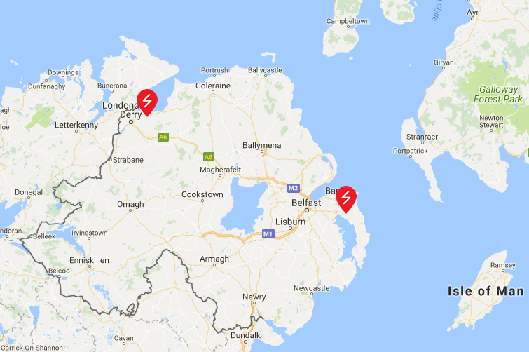
Sticking with those power cuts for the moment, here are the lunchtime maps from the assorted Distribution Network Operators spread across the west and north of the British Isles:
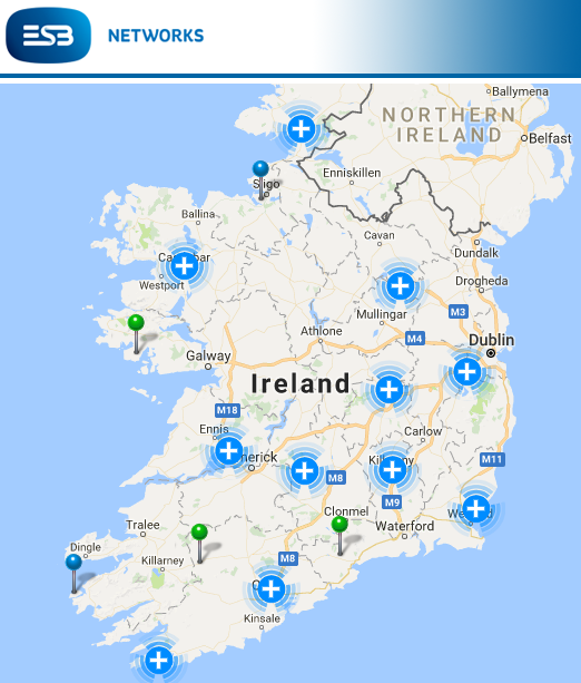
ESB-2017-12-07_1308

NIE-2017-12-07_1309

ENW-2017-12-07_1311

Scottish and Southern Energy Networks:
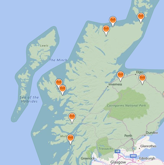
SSEN-2017-12-07_1312

Scottish Power Energy Networks don’t provide an overview map of the area covered by their network, but they do issue severe weather updates from time to time. Today’s currently states that:

The MET Office has issued a yellow/amber warnings for Thursday 7th December 2017 to much of Scotland. Storm Caroline is expected to bring a spell of very windy weather reaching up to speeds of 80mph over the higher grounds.

Moving into Friday 8th and Saturday 9th, the yellow Met Office warning is still in place and it now covers Scotland, North Wales and Northwest Midlands. The yellow warning continues to bring strong winds but also frequent snow showers of 2-5cm, with 10-20cm in some places.

Icy surfaces are also likely to be an additional hazard, especially overnight. The heaviest and most frequent snow showers will progressively become confined to northeast Scotland during Saturday.

We have not yet seen any impact of Storm Caroline on our Network and as such we are presently working as business as usual, however, we will continue to monitor the weather situation closely.

Scottish and Southern do however provide timely news updates. The lunchtime edition reports that:

As forecast, gale-force winds reached the Western Isles from the early hours of this morning, with wind gusts in excess of 85mph recorded. SSEN’s network has stood up well to the initial impact and power has been safely restored to over 3,900 customers, mainly on the Western Isles and north-west Highlands, with around 780 homes currently without power as of 12pm today.

The full impact of Storm Caroline has not yet been felt across much of SSEN’s network region and it is expected there will be further faults throughout the day as the weather front continues to track across the north Highlands, into the Moray Firth and up to Orkney. Winds are expected to peak between midday and 6pm this evening with gusts of 70 -95mph forecast. Shetland is expected to feel the full force of Storm Caroline from midnight tonight through to lunchtime on Friday.

With snow and falling temperatures forecast for Friday, there is also a risk of line icing, where snow accumulates and freezes on the overhead electricity network, which can result in damage due to the sheer weight of accumulated snow and ice. Infrequent lightning also remains a risk.


[Edit – December 7th 18:00]

Firstly here are the tea time power cut maps:
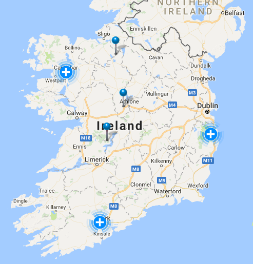
ESB-2017-12-07_1751

NIE-2017-12-07_1753

ENW-2017-12-07_1754

SSEN-2017-12-07_1757

SPEN still haven’t updated their “Severe weather update” from yesterday.

SSEN have issued a 4 PM update, which reads as follows:
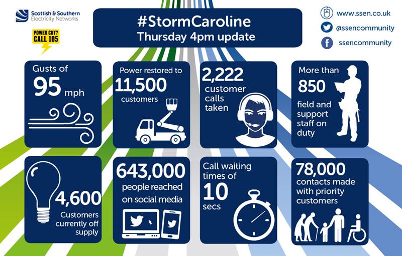
SSEN-News-2017-12-07-1600

As forecast, gale-force winds have tracked slowly across SSEN’s network region, starting in the Western Isles in the early hours of the morning with the storm moving from west to east throughout the day. Wind gusts of 95mph have been recorded at Burgar Hill in Orkney, with widespread gusts in excess of 80mph observed across the north of Scotland.

SSEN’s network continues to stand up well to the impact of Storm Caroline and power has been safely restored to over 11,500 customers. The main areas affected have been the Western Isles, north-west Highlands, Caithness, Moray, north-east Aberdeenshire, Orkney and Shetland.

As of 4pm, around 4,600 homes remain without power, mainly in Caithness, Orkney and Shetland. All faults are resourced with teams working to restore power, where it is safe to do so.

Wind speeds are forecast to subside for most parts from around 6pm this evening, with the exception of Shetland which is expected to continue to feel the effects of Storm Caroline through to tomorrow morning.

With snow and falling temperatures forecast for Friday, SSEN will remain on Yellow Alert due to the risk of line icing, where snow accumulates and freezes on the overhead electricity network, which can result in damage due to the sheer weight of accumulated snow and ice. A risk of lightning also remains.

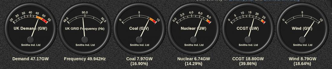
Whilst the far north of Scotland may be experiencing very strong winds, further south wind turbines across the nation will be spinning furiously, so lets now take a look at the mix of UK electricity generation at the moment, courtesy of Gridwatch:
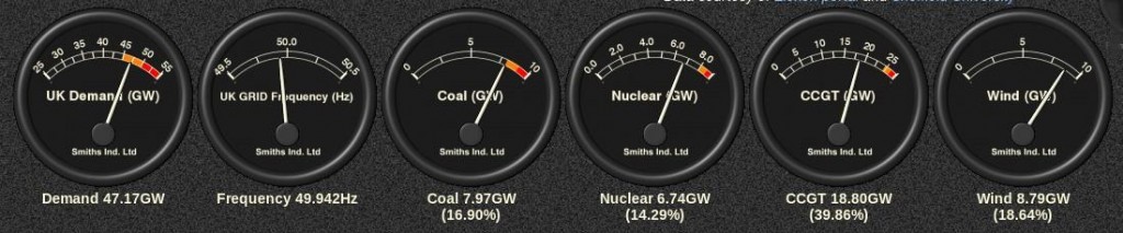
GridWatch-Main-20171207-1720

We’re currently experiencing the usual early evening peak in demand and we’re also experiencing a bit of a cold snap at the moment:

Hence there’s also an “amber warning” for electricity demand this evening, with wind contributing almost 9 GW of the required 47.17 GW. Here’s how that looks expressed as UK plc’s “Carbon intensity“:
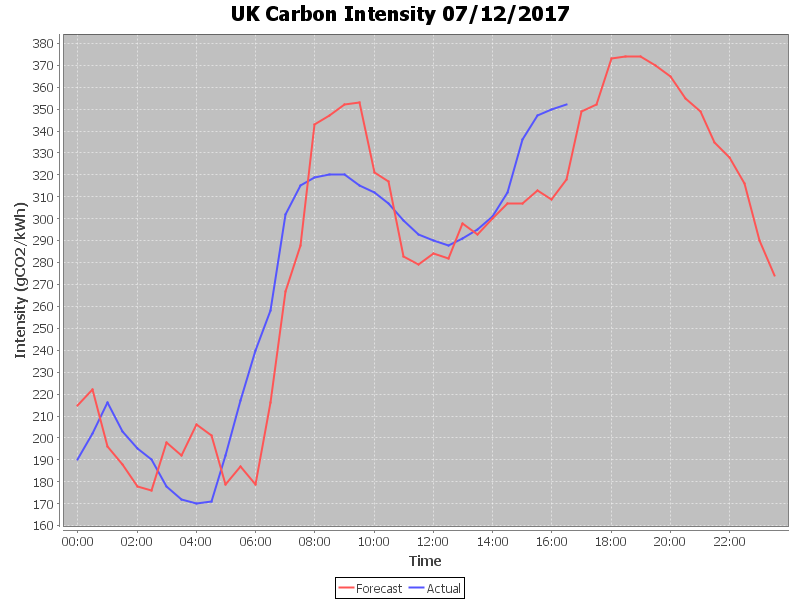
CarbonIntensity_20171207-053211


[Edit – December 7th 22:30]

Our suite of power cut maps reveal that the worst effects of Storm Caroline are now confined to the far north east of Scotland, including Orkney and Shetland:
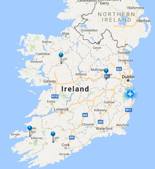
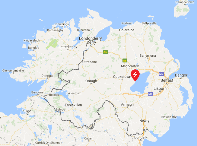
ESB-2017-12-07_2226

NIE-2017-12-07_2227

ENW-2017-12-07_2229

SSE-2017-12-07_2231

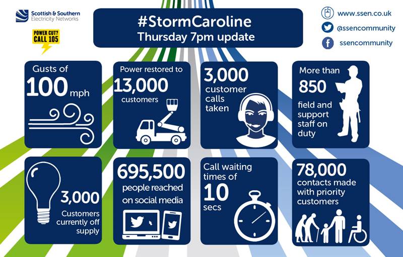
Scottish and Southern have issued another updates:
SSEN-News-2017-12-07-1900

From the early hours of this morning, gale-force winds have battered the north of Scotland, tracking slowly across SSEN’s network region from west to east throughout the course of the day. Over the last few hours, Shetland has borne the brunt of Storm Caroline, with wind gusts of over 100mph recorded at Gremista.

Power has been safely restored to over 13,000 customers across SSEN’s network, the main areas affected being the Western Isles, north-west Highlands, Caithness, Moray, north-east Aberdeenshire, Orkney and Shetland. With wind speeds now starting to subside for most areas it is anticipated the vast majority of customers will be restored this evening. As of 7pm, there are currently 3,000 customers still off supply, 1,300 of which are in Shetland.

Due to the continued severity of the wind speeds experienced in Shetland, which are forecast to continue through to tomorrow morning, and access issues affecting a small number of customers on Orkney, it is likely that some homes will remain off supply overnight. SSEN’s teams remain on standby and will carry out repairs as soon as it is safe to do so.

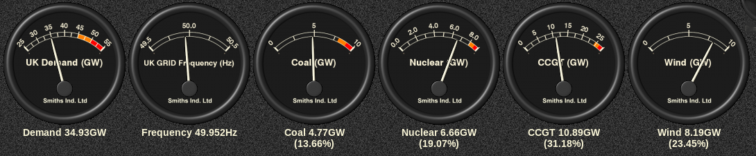
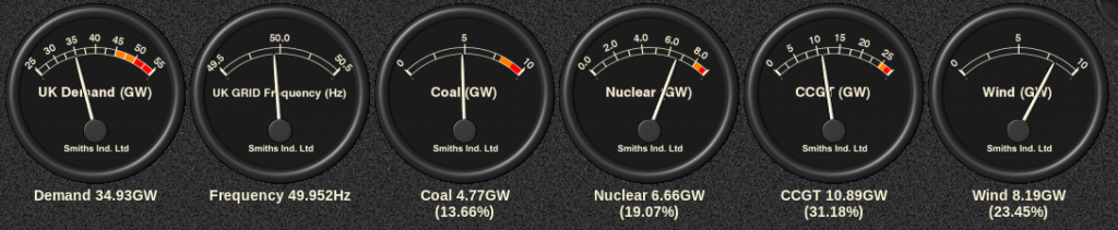
As the evening has progressed UK electricity demand has dropped as forecast, and the generation mix now looks like this:
GridWatch-Main-20171207-2250


[Edit – December 8th 07:00]

There’s still a wind warning in place for the Northern Isles:

Consequently Scottish and Southern’s map of power cuts in the area still looks like this at the moment:
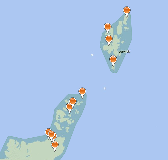
SSEN-2017-12-08_0657

Scottish and Southern issued a further update on Storm Caroline late last night:

Following the impact of Storm Caroline, which has seen prolonged gale force winds affecting many areas across the north of Scotland, SSEN has now successfully reconnected the vast majority of homes affected, with power safely restored to over 14,000 customers. The main areas affected have been the Western Isles, north-west Highlands, Caithness, Moray, north-east Aberdeenshire, Orkney and Shetland.

Due to the persistent and severe nature of wind speeds still being felt across parts of Caithness, Orkney and Shetland, coupled with difficulty gaining access to faults, as of 10pm this evening SSEN has taken the decision to stand down its field based teams in these locations for safety reasons and around 500 customers will remain off supply overnight.

Here’s the UK’s generation mix this morning:
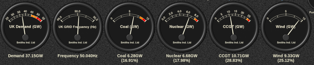
GridWatch-Main-20171208-0700

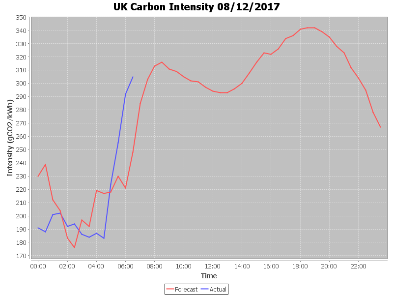
and here’s the final UK plc carbon intensity graph for yesterday:
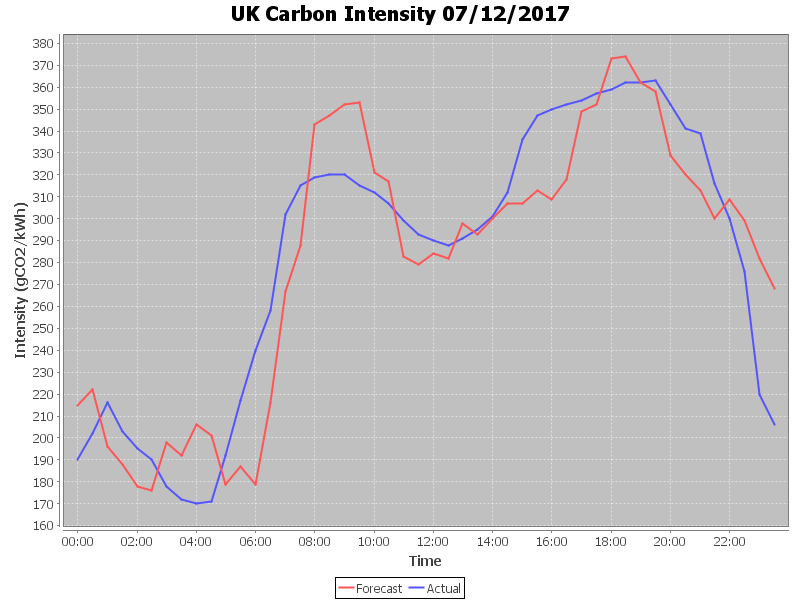
CarbonIntensity_20171207

plus today’s thus far:

CarbonIntensity_20171208-070858


[Edit – December 8th 15:00]

Scottish and Southern’s map of power cuts still shows several outages this afternoon:
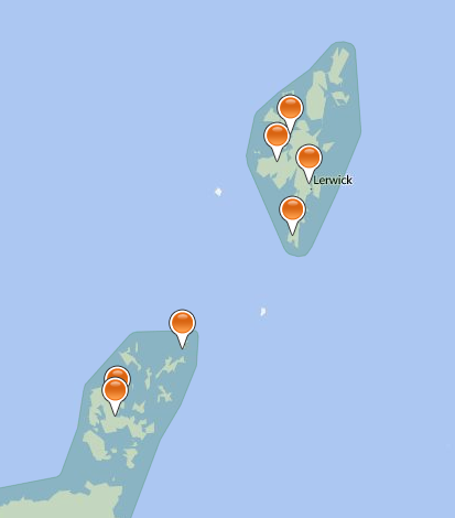
SSEN-2017-12-08_1452

In their latest bulletin they say that:

SSEN’s teams continue to make good progress to restore power to the last remaining customers affected by the impact of Storm Caroline, which brought sustained gale force winds to many areas across the north of Scotland. Throughout the course of the event, SSEN has successfully reconnected power to over 18,000 homes. The main areas affected have been the Western Isles, north-west Highlands, Caithness, Moray, north-east Aberdeenshire, Orkney and Shetland.

As of 2.30pm, just 250 homes remain off supply, with the main areas still affected being Orkney and Shetland. All faults have been resourced and SSEN anticipates all homes will have power restored by this evening.

To support efforts to restore power to those homes who remained off supply overnight, SSEN has moved additional teams to the areas affected and is also working closely with its resilience partners to help overcome challenges with gaining access to faults as a result of cancellations to local ferry services and road closures due to snow. This includes working in coordination with the RNLI, who are providing a helicopter to get additional teams and resource to South Ronaldsay, Orkney.

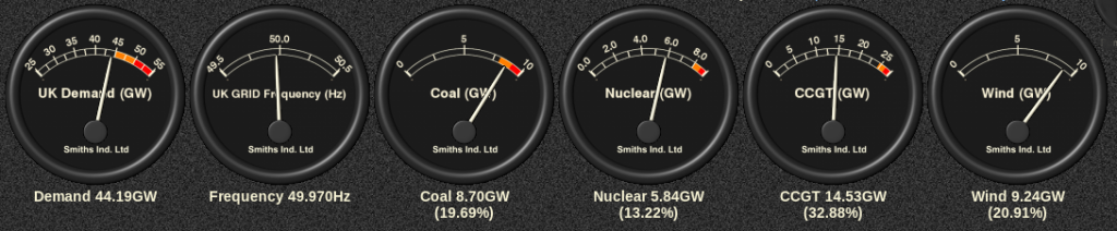
Here’s the current generation mix:
GridWatch-Main-20171208-1430


[Edit – December 8th 18:15]

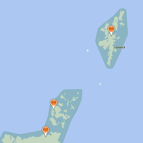
Scottish and Southern Electricity Networks say they:

Have now returned to business as usual but we will continue to monitor conditions and are well prepared to respond to whatever other challenges the Scottish weather has in store for us this winter.

Their current power cut map confirms that:
SSEN-2017-12-08_1802

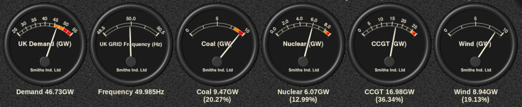
Much like yesterday, this evening’s demand is back up in the amber zone:
GridWatch-Main-20171208-1815


[Edit – December 9th]

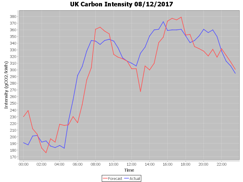
Here is the final UK plc carbon intensity graph for yesterday:
CarbonIntensity_20171208

Storm Doris Blacks Out Britain

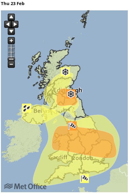
Here is the United Kingdom Met Office’s severe weather warning map for today:

According to the Met Office forecast for the West Midlands:
Some very strong winds are expected on Thursday in association with storm Doris with gusts of 60-70 mph likely, and 70-80 mph on coasts and hills.

There is still some uncertainty about the track of storm Doris, but increasing confidence that there will be widespread disruption across parts of England and Wales.

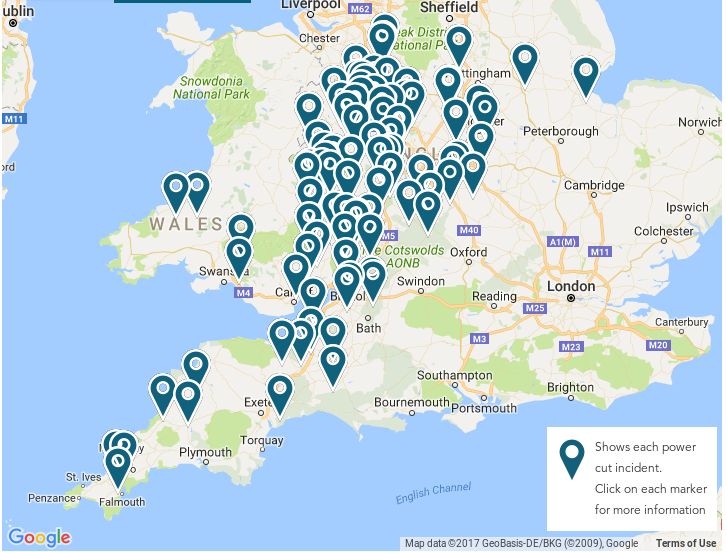
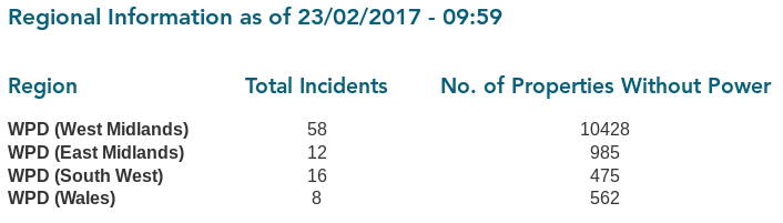
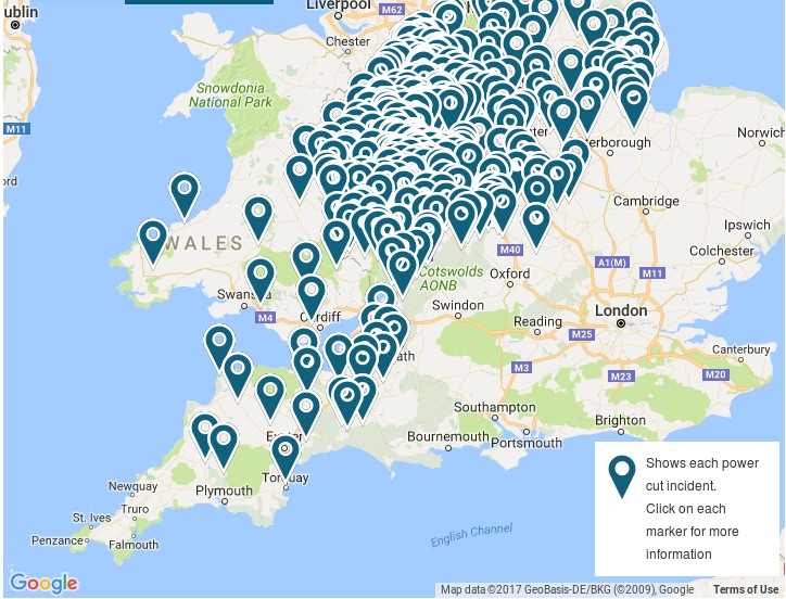
Earlier this morning we took a snapshot of Western Power Distribution’s live power cut map. It looked like this:

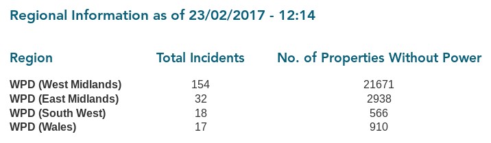
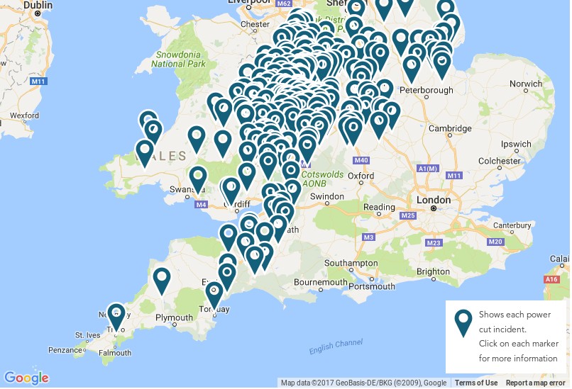
It’s now 10 AM on Thursday February 23rd, and WPD’s map now looks like this:


[Edit – Feb 23rd 12:15]

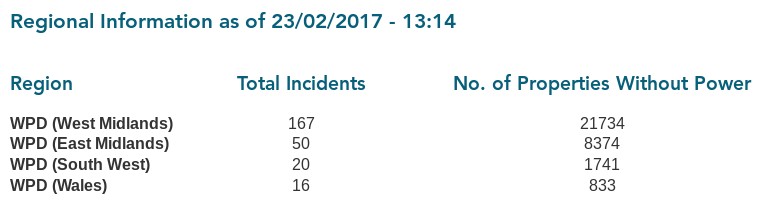
It’s now 12:15 PM on Thursday February 23rd. Over 20,000 properties are now without electric power in Western Power Distribution’s West Midlands region alone:

Electricity Northwest are tweeting helpful information to their online customers:

So are UK Power Networks:

However if you’ve just had a power cut you’d need to have a UPS for your PC in order to read those helpful messages! Or a fully charged mobile device with nearby comms towers still powered up!


[Edit – Feb 23rd 13:15]

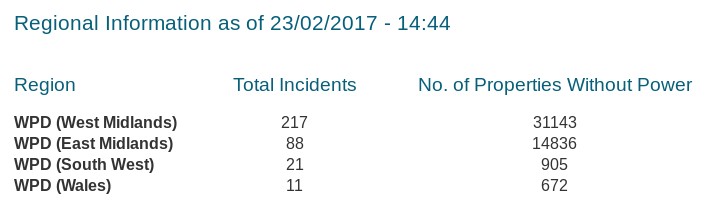
It’s now 13:15 on Thursday February 23rd. Over 30,000 properties are now without electric power across Western Power Distribution’s East and West Midlands regions:

Scottish & Southern Energy Networks have issued a news release:

SSEN engineers are making good progress in reconnecting customers affected by damage to overhead lines and network equipment. Since midnight, SSEN engineers have successfully restored power to over 22,000 homes, with approximately 5,000 homes currently without power. All faults are fully resourced and all customers are expected to be restored tonight.

The worst of the conditions have been observed in Oxfordshire, Berkshire and Hampshire where a wind gust of 65mph was recorded in Odiham.

SSEN has more than 1,000 engineering, technical and support staff on duty. Ahead of the storm, engineering teams were mobilised to key locations to minimise disruption and inconvenience to customers.

Customer service teams have been contacting over 7,000 customers on our Priority Service Register to check on their wellbeing in case they need additional help.


[Edit – Feb 23rd 14:45]

It’s now 14:45 on Thursday February 23rd. Over 45,000 properties are now without electric power across Western Power Distribution’s East and West Midlands regions:


[Edit – Feb 23rd 16:00]

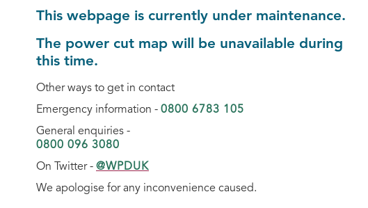
It’s now 16:00 on Thursday February 23rd. WPD’s live power cut map is down for maintenance:

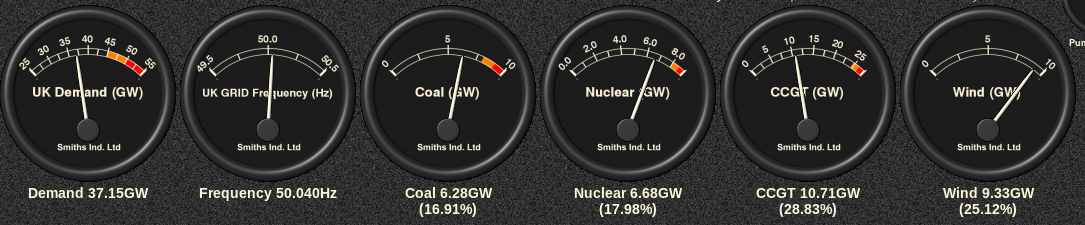
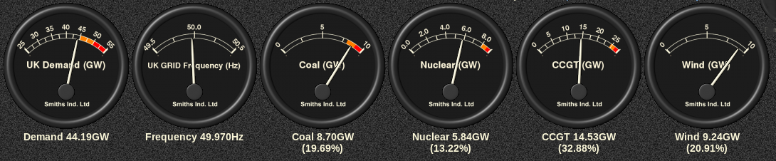
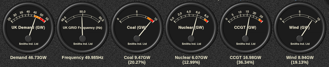
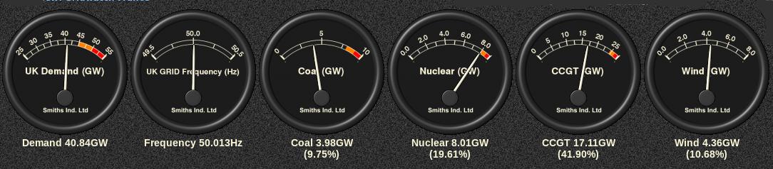
It’s obviously fairly breezy across the United Kingdom today! Let’s take a look at the current UK electricity generation mix at the moment, courtesy of GridWatch:

Western Power Distribution have issued a severe weather update:

We are currently exceptionally busy within WPD with the East and West Midlands area being especially affected in particular by the effects of Storm Doris so far.

Issued on: Thursday 23rd February – 3pm

The West Midlands has been significantly affected with almost 22,000 customers currently off supply with the vast majority being affected between 09:00 and 12:00 with Hereford, Ludlow, Worcester, Telford and Stoke suffering the worst effects.

During the last hour the fault rate in East Midlands has picked up where we have around 10,000 without power as the storm is now tracking eastwards as expected.

Our engineers are currently working hard to restore supplies as quickly and safely as possible, and we have additional staff in our Contact Centres, Control Rooms and operational depots.

The South West and South Wales areas were impacted earlier today, but not exceptionally so. Both areas have fewer than 3,000 customers affected and all incidents are currently resourced and being worked on.

Electricity North West have issued a press release, which begins:

Engineers from Electricity North West are working in difficult conditions today to restore power as Storm Doris hits the North West.

The region’s power network operator has restored supplies to around 5,000 properties throughout the morning following the Met Office’s amber weather warning for severe gales of 70 to 80mph and a yellow warning for snow to hit the North West today.

Around 2,500 properties remain without power as flying debris has hit lines and high winds make access difficult for repair teams. Properties are affected mainly in Lancashire, Manchester and the Peak district including250 properties currently without power in Horwich, Bolton.


[Edit – Feb 23rd 17:00]

It’s now 17:00 on Thursday February 23rd. WPD’s live power cut map is still down. However SSEN have issued a 4 PM update:

SSEN engineers are making good progress in reconnecting customers affected by damage to overhead lines and network equipment. Since midnight, power has been restored to over 29,000 homes, with approximately 8,000 homes currently without power. All faults are fully-resourced and we are working to restore power to all customers tonight.

The worst of the conditions have been observed in Oxfordshire, where around 5,000 customers are currently without power, as well as parts of Berkshire and Hampshire.


[Edit – Feb 23rd 18:30]

It’s now 18:30 on Thursday February 23rd. WPD’s live power cut map is still down! SP Energy Networks have now issued a press release:

The MET Office Amber warnings remain in place until 8pm tonight as Storm Doris continues to cause significant impact across the UK.

SP Energy Networks distribution licence area in Cheshire, Merseyside and North Wales has experienced extreme weather conditions today, with wind gusts of over 90mph experienced in exposed areas. Over the course of today we have restored power to over 50,000 customers impacted by this severe weather.

Our restoration efforts have been hampered today by the gale force winds making it unsafe for our engineering teams to work at height. The winds have now reduced somewhat, albeit we are still seeing wind gusts in excess of 50mph in exposed areas.
However, where it is safe to do so, our restoration efforts will continue this evening and tonight. As a result of the extensive damage experienced today, we now expect that some customers will be without power overnight.

Where possible, we will endeavour to make contact with those customers impacted to discuss welfare options. We have been working with the Red Cross who will help support our vulnerable customers impacted by today’s events.

Electricity North West have issued another press release:

Engineers from Electricity North West will work into the evening and through the night to restore the final properties affected by Storm Doris.

The region’s power network operator has restored supplies to around 6,700 properties throughout the day following the winds of 70 to 80mph in the North West.

800 properties remain without power in a number of small pockets, mainly across Lancashire as flying debris and fallen trees have hit power lines in the region.

Western Power Distribution have issued another severe weather update:

The current situation within WPD is still exceptionally busy, with the East Midlands, and even more so the West Midlands areas still having large numbers of customers off supply due to the effects of Storm Doris that passed through our area today.

Issued on: Thursday 23rd February – 6pm

There are approximately 20,000 customers in the West Midlands off supply and we have restored around a further 20,000 throughout the day. As of the last update the worst affected areas have been Hereford, Ludlow, Worcester, Telford and Stoke.

There are currently fewer than 10,000 customers off supply in the East Midlands with us having restored a further 10,000 approximately throughout the day.

Whilst busy, the volume of faults affecting the South West and South Wales have not been too bad, with all incidents being worked on and resourced. There are currently fewer than 1,500 customers off throughout the two areas and staff from those areas have been moved into the Midlands to assist where required.

Our contact centre has dealt with over 22,000 calls from customers with an average speed of response time of 6.7 seconds.

We have had one helicopter airborne today flying from Nottingham that has inspected two EHV faults in Stoke and Telford. Tomorrow, all four aircraft will be available from first light to aid and assist in repairs as required.


[Edit – Feb 23rd 20:00]

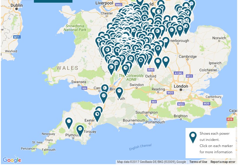
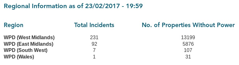
It’s now 20:00 on the evening of Thursday February 23rd. WPD’s live power cut map is operational again, and it’s moved to a dedicated subdomain! Here is what it reveals:


[Edit – Feb 23rd 22:30]

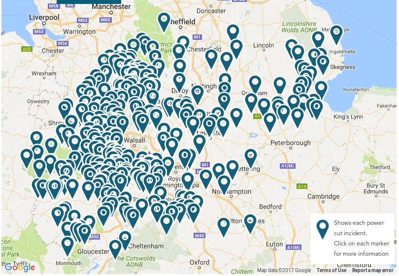
This will be our last update for today, at 22:30 on the evening of Thursday February 23rd. First of all WPD’s live power cut map, zoomed in on the Midlands:

Next the 20:00 update from Scottish and Southern:

Since midnight, power has been restored to over 30,000 homes, with approximately 4,000 homes currently without power. All faults are fully-resourced and engineers are working to restore power to all customers tonight.

Storm Doris brought severe winds, with gusts of up to 65mph, across the region. The worst of the conditions were felt in Oxfordshire, where around 2,500 customers are currently without power. Extra linesman and repair teams have been despatched to the area to aid restoration efforts. Parts of Berkshire and Hampshire were also affected.

Finally the 21:30 update from Scottish Power:

Over the course of the day our distribution licence area in Cheshire, Merseyside & North Wales has experienced extreme weather conditions, including winds in excess of 90mph. As a result of these storm force winds, our network has sustained a level of damage resulting in a loss of power for some of our customers. Despite the extremely challenging conditions, and the restrictions that our teams have faced working at heights in such extreme conditions, our engineers have worked tirelessly over the course of today to restore power to as many homes as possible, restoring power to over 66,000 people. However, a number of customers will remain without power overnight and we will make every effort to contact these customers tonight.

We continue to work to maximise our resource levels, with additional engineering teams from our Scottish distribution area already dispatched to support the restoration efforts as well as continuing to work with our contracting partners to secure additional resources. We will also be looking to mobilise helicopters tomorrow morning to help the fault finding process on some of the more challenging terrain.

For a warming nightcap after the blustery day here’s the GridWatch UK electricity generation mix tonight, including the minor contributors: