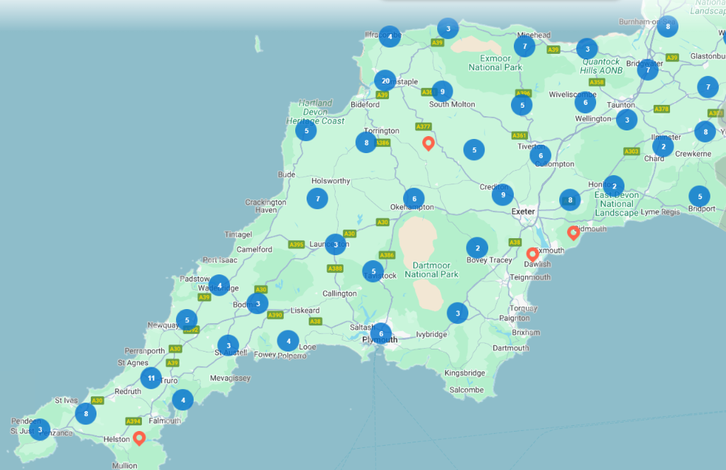
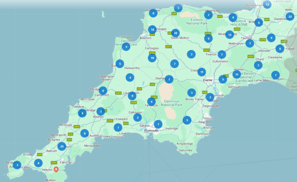
Storm Darragh arrived in the West Country yesterday. causing carnage far and wide. Here is how the Devon and Cornwall section of National Grid Electricity Distribution’s power cut map looked at 4 PM:
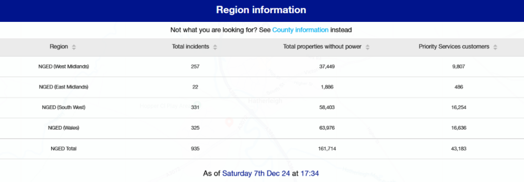
Somewhat later, here’s how NGED’s table of regional power outages looked:
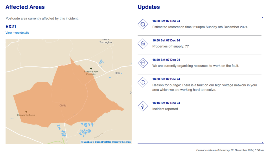
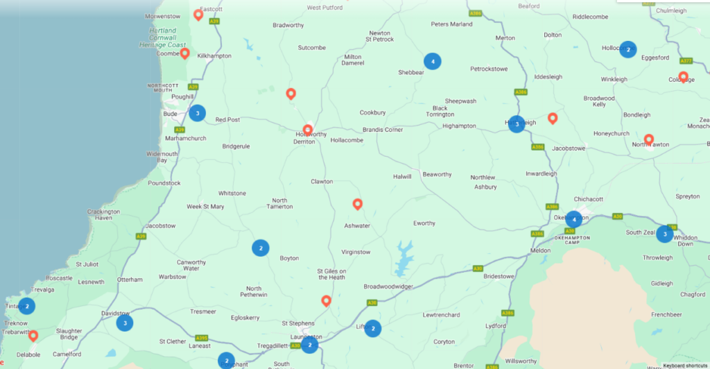
77 of the 58,423 properties in the South West without an electricity supply were just up the road from us near Chilla:
By 8:30 PM the NGED power cut map was awash with outages:
while our local area looked like this:
The power cut in Chilla was rather confusingly located in Hatherleigh according to the map!
This morning the Met Office in Exeter issued a warning of high winds due to the imminent arrival of Storm Betty, the second named storm of this tempestuous summer!
Met Éireann have named Storm Betty as a low-pressure system which is also triggering Met Office warnings…
A Met Office yellow warning for wind covers coastal areas of western Wales, eastern Northern Ireland and parts of northwest England and southwest Scotland. Rain warnings have also been issued from late Friday and into Saturday for Northern Ireland and parts of Scotland.
According to the yellow warning for wind:
Power cuts may occur, with the potential to affect other services, such as mobile phone coverage
In such circumstances I have a penchant for recording “baseline” images of the UK’s distribution network operators’ power cut maps. I was rather surprised to discover that Northern Powergrid’s looked like this earlier today:
Zooming in on the map, it seems many of those alleged power outages have been “scheduled” in advance, some of which remain on the map despite having already been cancelled for today.
It remains to be seen how many “unscheduled” additions Storm Betty leaves in her wake.
[Update – August 18th 20:30]
The predicted “unscheduled” power cuts due to the passage of #StormBetty across the British Isles have begun.
Here are the current power outage maps of ESB Networks in Eire:
Storm force winds associated with Storm Betty caused damage to the electricity network overnight affecting just over 70,000 homes, farms and businesses at the peak. As at 11.30am, just under 50,000 electricity customers remain without power with the damage mainly attributable to lightning and fallen trees on overhead lines as a result of the high winds.
Areas most impacted include counties in the South-East along with North Dublin, Dundalk, Portlaoise and Kilkenny.
All available resources are being deployed to respond to all electricity outages where safe to do so. ESB Networks crews have been working since first light and will work through this afternoon into this evening to restore power to as many customers as possible. A significant number of impacted customers will have their power restored by this evening. However, due to the scale of the damage to the electricity network, some customers in localised areas may remain without supply overnight.
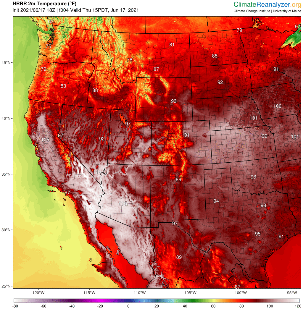
Midsummer’s Day is a few days away, and on the west coast of the United States things are heating up. Here is the surface temperature map for the western USA yesterday afternoon:
Those sort of temperatures mean that lots of air conditioning units are working hard, and consequently the California Independent System Operator (CAISO for short) called for a voluntary “Flex Alert” yesterday, in order to persuade its customers to voluntarily reduce electricity demand:
The California ISO's first #FlexAlert of the year takes effect this evening, with consumers encouraged to voluntarily conserve electricity from 5 p.m. – 10 p.m. to help maintain grid stability. Read the news release: https://t.co/vg1581QXm1pic.twitter.com/7gcIgP8MWm
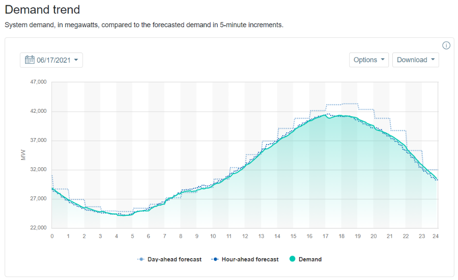
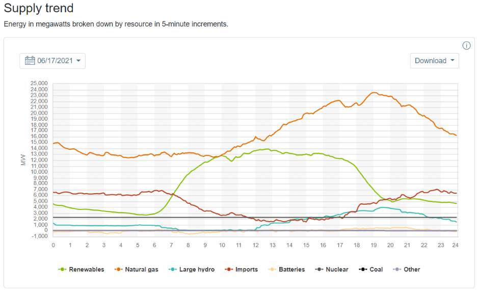
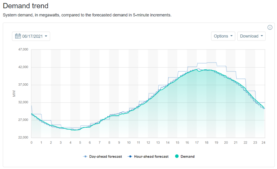
The desired aim seems to have been achieved, with the evening demand peak having been “shaved” somewhat, and with last year’s rolling blackouts averted so far in 2021:
Here’s how the differing sources of electricity supply coped:
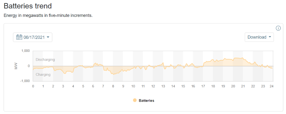
Here’s an expanded view of the contribution of the ever expanding amount Californian battery storage to electricity supply during the evening demand peak:
The California heat wave is forecast to continue today, as is another high peak in demand:
Louisiana still hasn’t recovered from the damage caused by the passage of Hurricane Laura last month. Here’s how the state’s power outage map looks this morning (UTC):
Now yet another storm is heading for the coast of the Gulf of Mexico. Tropical Storm Sally is forecast to increase in strength to hurricane force before crossing the coast further to the east than Laura:
CENTER LOCATED NEAR 28.2N  86.2W AT 14/0300Z
ESTIMATED MINIMUM CENTRAL PRESSURE  996 MB
MAX SUSTAINED WINDS  50 KT WITH GUSTS TO  60 KT.

FORECAST VALID 14/1200Z 28.6N  87.3W
MAX WIND  60 KT...GUSTS  75 KT.

FORECAST VALID 15/0000Z 29.0N  88.3W
MAX WIND  70 KT...GUSTS  85 KT.

FORECAST VALID 15/1200Z 29.4N  89.0W
MAX WIND  80 KT...GUSTS 100 KT.

FORECAST VALID 16/0000Z 30.3N  89.4W...INLAND
MAX WIND  70 KT...GUSTS  85 KT.
[Edit – September 16th 10:00]
Hurricane Sally is currently making landfall further east than originally forecast:
Here’s the NHC’s current forecast track for Sally:
NOAA buoy 42012, located about 50 miles southeast of Mobile,
Alabama, recently reported a sustained wind of 71 mph (115 km/h) and
a pressure of 970.9 mb inside the eastern portion of Sally's eye.

SUMMARY OF 300 AM CDT...0800 UTC...INFORMATION
----------------------------------------------
LOCATION...30.0N 87.8W
ABOUT 50 MI...75 KM SW OF PENSACOLA FLORIDA
ABOUT 55 MI...85 KM SE OF MOBILE ALABAMA
MAXIMUM SUSTAINED WINDS...105 MPH...165 KM/H
PRESENT MOVEMENT...NNE OR 020 DEGREES AT 3 MPH...5 KM/H
MINIMUM CENTRAL PRESSURE...965 MB...28.50 INCHES
So far Alabama has suffered the most, with almost 200,000 power cuts currently.
At the moment I’m too busy writing about the seemingly never ending sequence of power cuts due to “extreme weather” events to wax lyrical about developments in vehicle-to-grid technology!
In California the heat wave is over and rolling blackouts a thing of the past, for the moment at least. However the wildfires continue, and the Lawrence Berkeley National Laboratory is temporarily closed:
UPDATE: Our Lab is closing at midnight tonight (Aug. 24) due to high fire danger and probability of lightning strikes in the #EastBay hills overnight. We have reached this decision because the health & safety of our people is our highest priority. Details: https://t.co/EhcTW0xdg2
Meanwhile in the Gulf of Mexico tropical storms Laura and Marco are simultaneously heading for the Louisiana coast. Laura is forecast to be a hurricane by the time she gets there, with Marco being merely an ex hurricane by landfall later today.
Now this morning comes news that hot on the heels of Storm Ellen last week, which caused many tens of thousands of properties in Ireland to suffer a power cut, the United Kingdom’s Meteorological Office has named Storm Francis:
Further power cuts are expected in the near future, on the shores of both the Gulf of Mexico and the North Atlantic! Here is the local wind forecast for the V2G Group office in (Silic)Inny Valley, North Cornwall, courtesy of MeteoCiel:
Please note that this forecast is for the peak of the post 2020 Covid-19 lockdown Cornish staycation season, not the middle of winter!
[Edit – August 25th 08:00]
As the winds from Storm Francis increase over South West England let’s take a quick look at current and projected electricity generation for today:
Plus today’s Octopus Energy Agile electricity tariff for South West England:
and the United Kingdom’s carbon intensity forecast:
[Edit – August 25th 22:00]
Here’s an image of Storm Francis over the British Isles recorded earlier today by the Suomi satellite: