Storm Betty’s Forecast Threatens UK Power Cuts

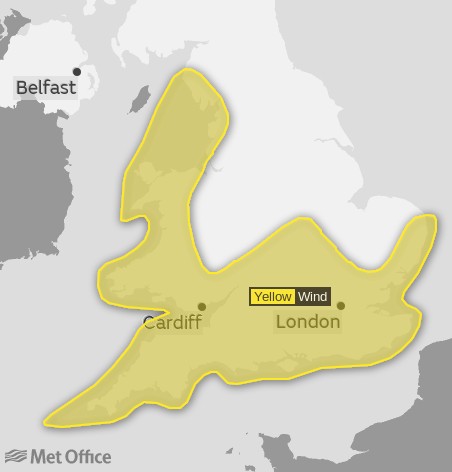
This morning the Met Office in Exeter issued a warning of high winds due to the imminent arrival of Storm Betty, the second named storm of this tempestuous summer!

According to the press release:

Met Éireann have named Storm Betty as a low-pressure system which is also triggering Met Office warnings…

A Met Office yellow warning for wind covers coastal areas of western Wales, eastern Northern Ireland and parts of northwest England and southwest Scotland. Rain warnings have also been issued from late Friday and into Saturday for Northern Ireland and parts of Scotland.

According to the yellow warning for wind:

Power cuts may occur, with the potential to affect other services, such as mobile phone coverage

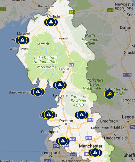
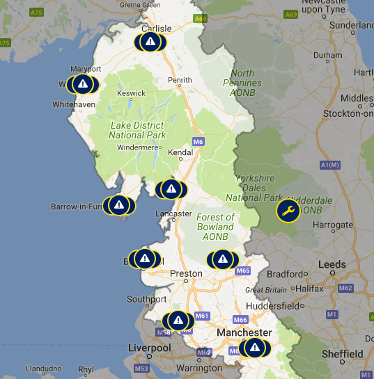
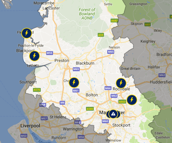
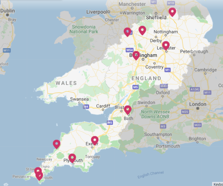
In such circumstances I have a penchant for recording “baseline” images of the UK’s distribution network operators’ power cut maps. I was rather surprised to discover that Northern Powergrid’s looked like this earlier today:

Zooming in on the map, it seems many of those alleged power outages have been “scheduled” in advance, some of which remain on the map despite having already been cancelled for today.

It remains to be seen how many “unscheduled” additions Storm Betty leaves in her wake.

[Update – August 18th 20:30]

The predicted “unscheduled” power cuts due to the passage of #StormBetty across the British Isles have begun.

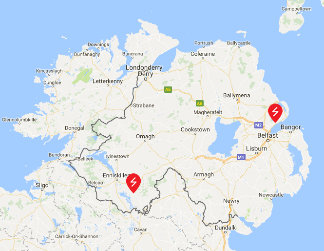
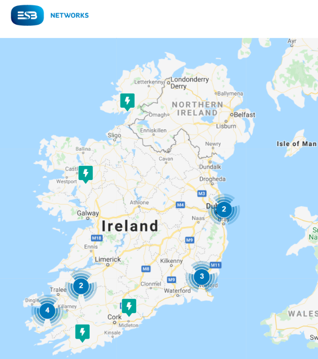
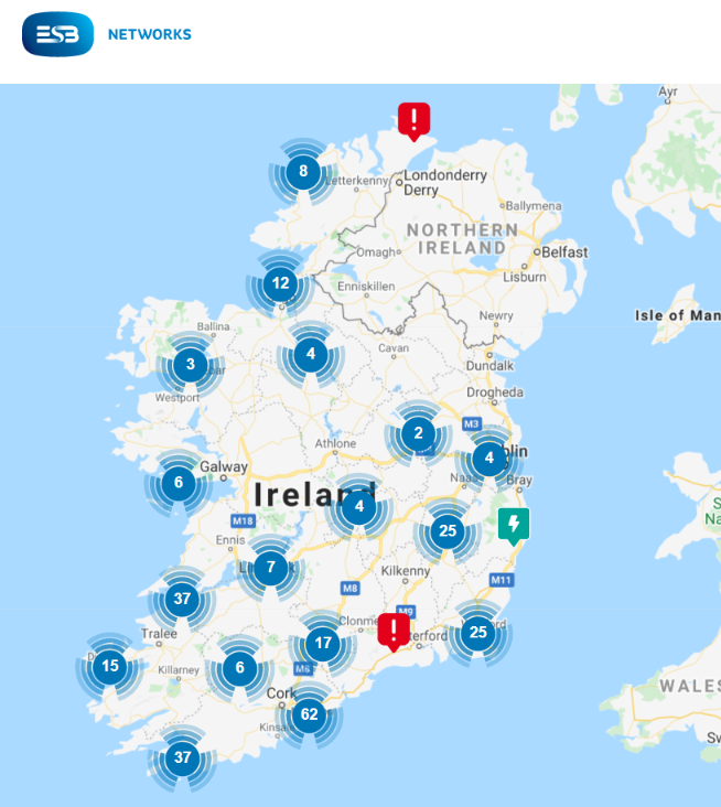
Here are the current power outage maps of ESB Networks in Eire:

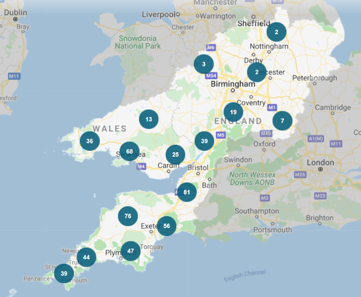
and National Grid in South West England:

[Update – August 18th 23:00]

It is clear tonight that inhabitants of Ireland are feeling the effects of Storm Betty far more than us here in South West England:

[Update – August 19th]

This morning National Grid’s power cut map doesn’t look significantly different to an average day:

Unfortunately the same cannot be said of the ESB Networks map:

or the NIE Networks map for that matter:

At 11:50 AM ESB Networks issued a press release:

Storm force winds associated with Storm Betty caused damage to the electricity network overnight affecting just over 70,000 homes, farms and businesses at the peak. As at 11.30am, just under 50,000 electricity customers remain without power with the damage mainly attributable to lightning and fallen trees on overhead lines as a result of the high winds.

Areas most impacted include counties in the South-East along with North Dublin, Dundalk, Portlaoise and Kilkenny.

All available resources are being deployed to respond to all electricity outages where safe to do so. ESB Networks crews have been working since first light and will work through this afternoon into this evening to restore power to as many customers as possible. A significant number of impacted customers will have their power restored by this evening. However, due to the scale of the damage to the electricity network, some customers in localised areas may remain without supply overnight.

To be continued…

Storm Otto Blacks Out Scotland

Yesterday morning the United Kingdom’s Met Office issued a press release about the impending arrival of a disruptive weather system:

A low-pressure system which will bring high winds and rain to parts of the UK has been named Storm Otto by the Danish Meteorological Institute (DMI).

Storm Otto will move east across the far north of the UK from the early hours of Friday morning, likely bringing gusts in excess of 75mph to some northern areas.

Met Office Chief Meteorologist Andy Page said: “Storm Otto will bring high winds and rain to the UK, with some northern parts of Scotland and the northeast of England likely to get the strongest gusts of wind, possibly in excess of 75mph. Warnings have been issued and could be updated as Storm Otto develops.

“There’s a chance of travel disruption and high-sided vehicles could be particularly prone to disrupted plans in this set-up. There’s associated rain with Storm Otto, with 40-50 mm of rain likely to fall over parts of western Scotland.”

Potential impacts highlighted in the warning also the likelihood of large waves, especially in North Sea coasts, as well as a chance of some damage to buildings and infrastructure.

This was accompanied by a weather warning for high winds from Storm Otto:

Continue reading →

More March Power Cuts in Cornwall

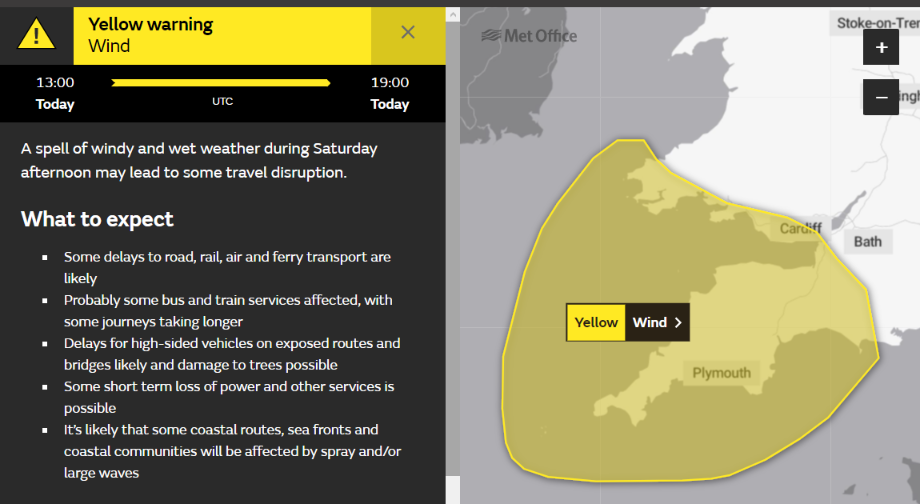
The UK’s Met Office has issued a yellow warning for wind and rain across South West England this afternoon:

As the Met Office point out:

Some short term loss of power and other services is possible.

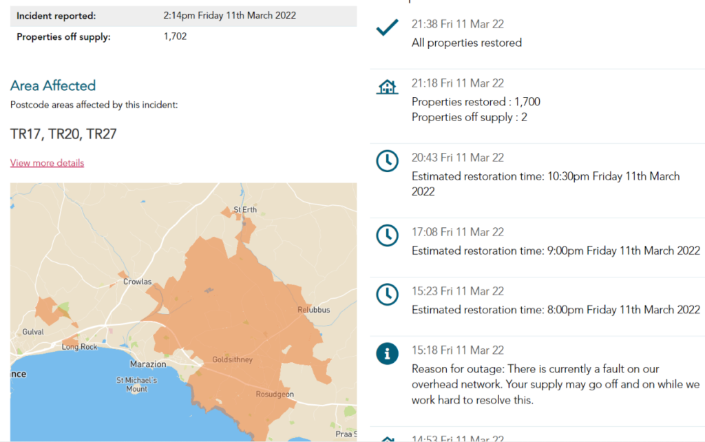
We would go somewhat further, and suggest that some power cuts are likely here in Cornwall. Not least because 1,702 properties near Marazion suffered a power cut yesterday afternoon:

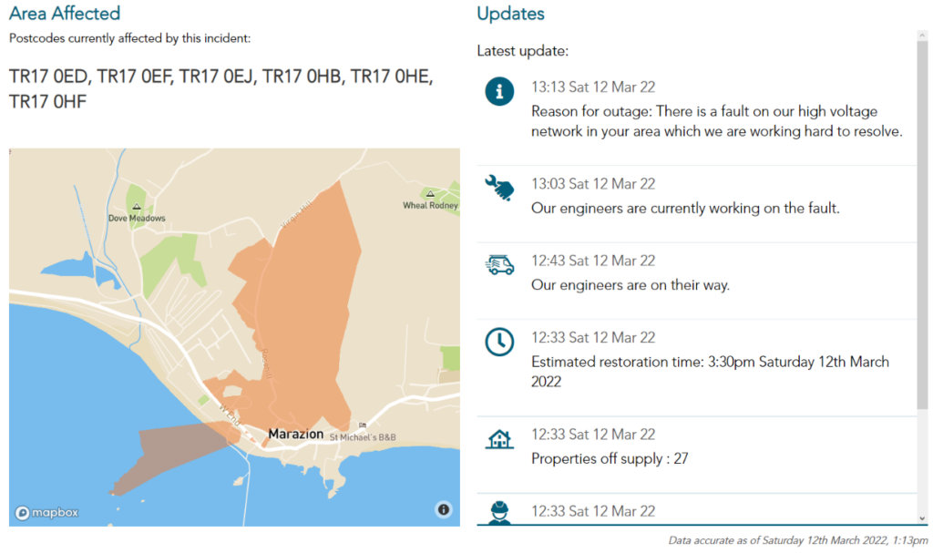
[Edit – 14:00 on March 12th]

Would you believe that this afternoon’s first Cornish power cut was in Marazion?

Watch this space!

Storm Eunice Wreaks Havoc

Regular readers may recall our own recent power cut in the wake of Storm Arwen before Christmas? Whether we experience another one tomorrow remains to be seen, but I am confident that many other people down here in South West England will.

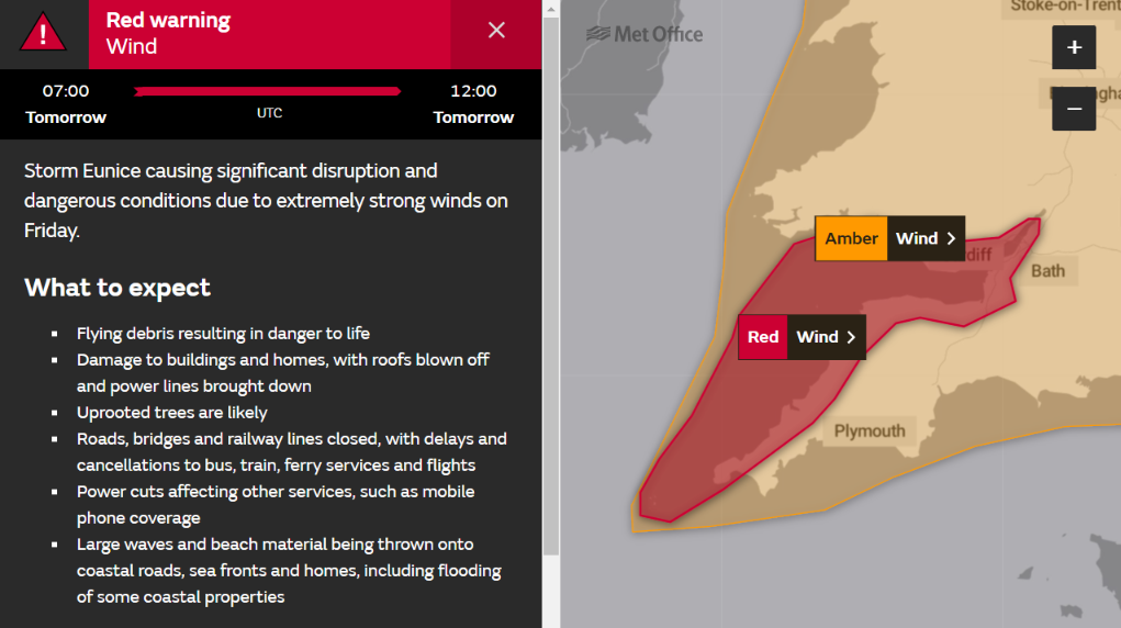
The Met Office issued a rare “red” wind warning for our part of the world earlier today:

The Met Office forecasts that:

Extremely strong west to southwesterly winds will develop over southwest England and south Wales early on Friday. Widespread inland gusts of 70-80 mph are likely and up to around 90 mph near some coasts, with dangerous conditions on beaches and seafronts. Winds are expected to ease from the west during the late morning.

What to expect

  • Flying debris resulting in danger to life
  • Damage to buildings and homes, with roofs blown off and power lines brought down
  • Uprooted trees are likely
  • Roads, bridges and railway lines closed, with delays and cancellations to bus, train, ferry services and flights
  • Power cuts affecting other services, such as mobile phone coverage
  • Large waves and beach material being thrown onto coastal roads, sea fronts and homes, including flooding of some coastal properties

In the aftermath of Storm Dudley here are the current power cut maps for Western Power Distribution:

and ESB Networks:

I cannot help but wonder what they will look like by noon tomorrow?

[Edit – 13:00 on February 18th]

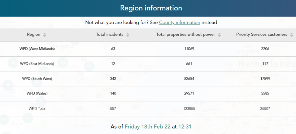
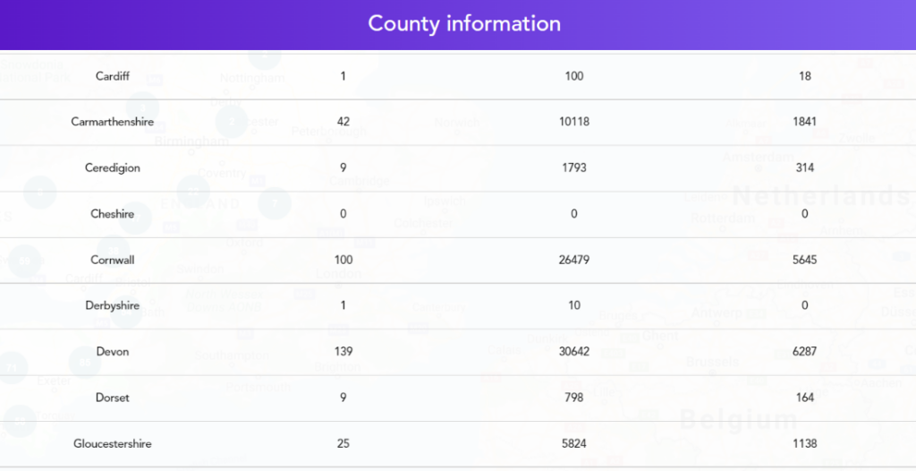
In a slightly belated answer to the question I posed last night, here are WPD’s current map and tables of woe:

Together with ESB Networks map for Eire:

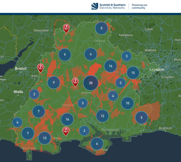
Plus Scottish and Southern’s south coast map:

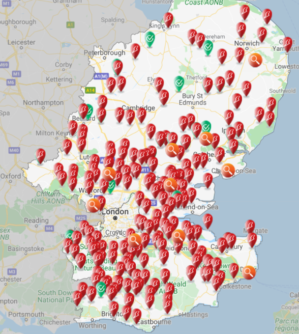
plus UK Power Networks’ map for South East England:

The other DNOs don’t provide handy tables of real time outage numbers, but WPD’s reveal that at 12:40 there were 123,955 properties without electric power across their four regions of the UK, of which 26,479 are here in Cornwall with another 30,642 next door in Devon.

Storm Franklin arrived on our shores before all the faults caused by Storm Eunice were repaired. Hence the story continues over at:

“Storm Franklin Power Cuts“


Storm Barra Barrels Towards Britain

As we anticipated yesterday, Storm Barra has been officially named by Met Éireann even though the remaining power cuts due to Storm Arwen have yet to be repaired:

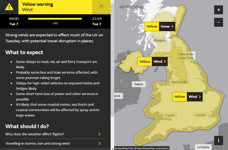
Here is the Met Office’s current high wind warning for Tuesday:

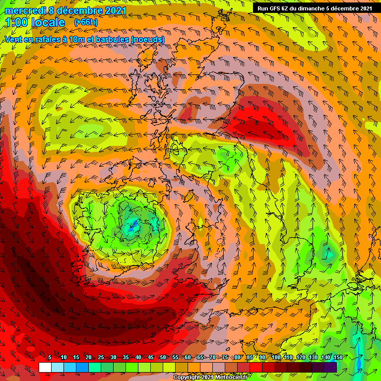
and here is the current GFS wind gust forecast for early Wednesday morning:

We anticipate more power cuts across Ireland as well as here in Cornwall and further afield across the United Kingdom.

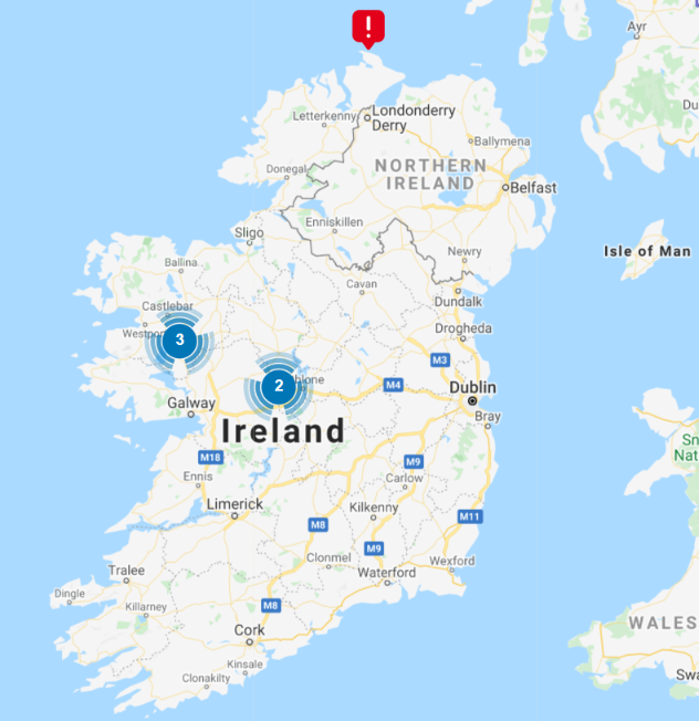
Here is ESB Networks’ view of the calm before Storm Barra:

[Edit – December 7th 09:00]

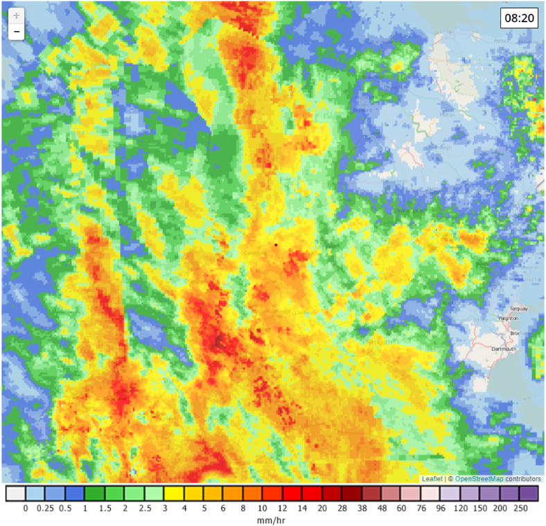
The rain from Storm Barra has recently arrived here in South West England:

Continue reading →

Storm Arwen Blacks Out Scotland

The United Kingdom’s Meteorological Office has officially named the first severe storm of the winter of 2021/22:

As you can see from the forecast above, very strong winds are forecast to hit the north east coast of Scotland later today, which will inevitably lead to a large number of power cuts.

The UK Met Office has now also issued a red weather warning for Storm Arwen:

https://twitter.com/metoffice/status/1464187971230482443

[Edit – November 26th 22:00]

High winds speeds in Scotland have been expected, but the coast of South Devon has also been subject to gusts over 60 mph:

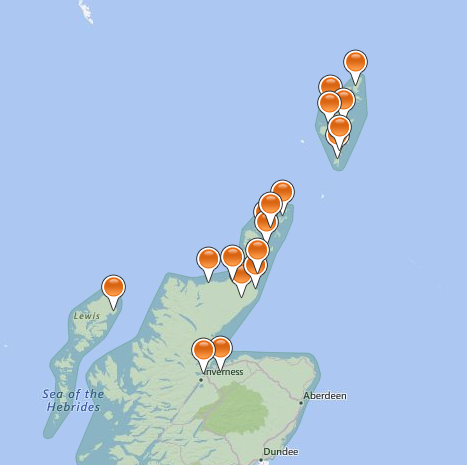
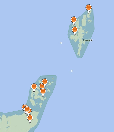
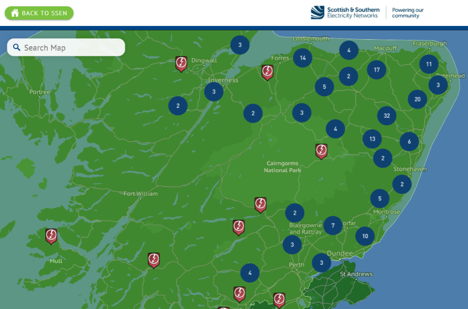
Here’s the latest power cut map for the north of Scotland from Scottish and Southern Electricity, showing a total of 201 “unplanned outages”:

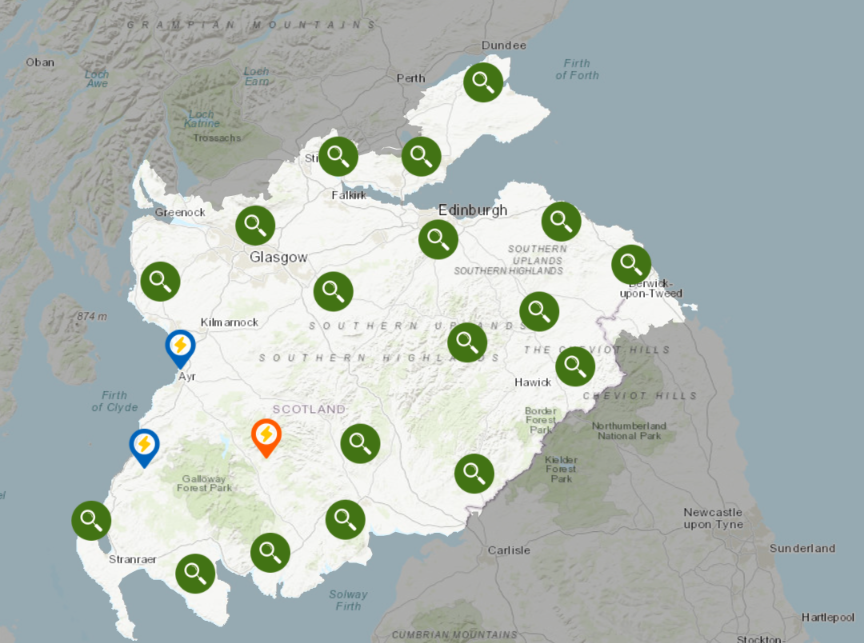
and here is Scottish Power’s map for further south:

Continue reading →

Weather Forecasts to Expand National Grid Capacity?

In a press release yesterday National Grid Group PLC announced that:

National Grid Electricity Transmission (NGET) has partnered with the Met Office on an innovative weather data project to help expand capacity on the electricity transmission network for wind and solar power.

The partnership is aiming to explore the value that can be derived from utilising higher specification weather forecasts to boost capacity on the electricity overhead transmission power lines, allowing more renewable energy to flow.

Currently, the electricity transmission system is limited by the individual power rating or capacity of the circuits connecting everyone across the country and, with the growth in renewable electricity generation, power flows across the existing grid infrastructure are changing, particularly at peak periods.

Historically, standard assumptions made for weather conditions have been conservative, therefore assets have operated at ratings lower than the actual capacity. To expand capacity, the £545k project, funded through the Ofgem’s Network Innovation Allowance mechanism, looks to utilise significant advances in weather forecasting by assessing the feasibility of integrating a cloud-based weather forecasting service into NGETs present Dynamic line rating (DLR) calculation methodology.

Assessing the DLR and varying the capacity of an overhead transmission power line dynamically, depends on the conductor’s physical properties as well as environmental factors such as wind speed, wind direction, ambient temperature, solar radiation etc.  If the environmental conditions are favourable enough to cool the conductors sufficiently, more power can be pushed through the lines, relieving some of the network constraints – helping to meet the country’s energy needs.

Given that the United Kingdom’s energy needs are currently being met at great expense, let us all hope that every little helps.

Tesco and the rest of us!

Power Cuts in SW England from Stormin’ Noname

Following in the footsteps of Storm Caroline a couple of days ago, another storm is now putting some people’s lights out here in South West England. This one doesn’t have an official name, but nonetheless here is the United Kingdom Met Office’s recent forecast:

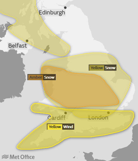
Whilst areas further north have an “amber” warning for snow, here is the Met Office’s official “yellow” wind warning for Southern England this morning:

UKMO-2017-12-10_0400

A spell of strong winds is expected to spread eastwards across the far south of the UK. Gusts of 50 mph are likely quite widely, with 60 mph gusts in places and close to 70 mph at times in the most exposed coastal locations. The highest gusts and strongest winds are expected Bristol Channel coastal areas during Sunday morning. High winds will also be accompanied by heavy showers, with a chance of hail and thunder, in parts of south Wales and southwest England.

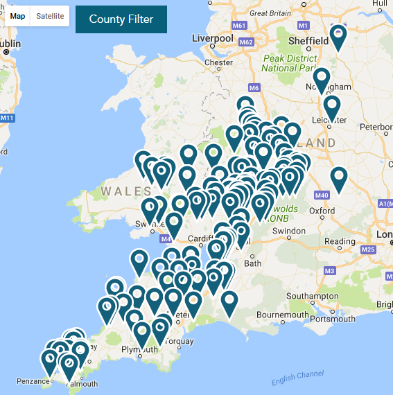
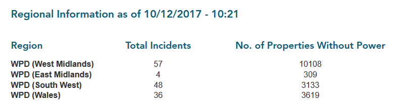
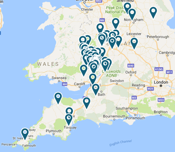
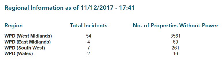
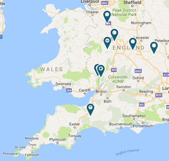
Those “strongest winds in Bristol Channel coastal areas” have certainly done some damage to Western Power Distribution’s electricity distribution grid this morning. It looks as though the snow and ice across the Midlands has had an effect too:

WPD-Map-2017-12-10_1028

WPD-Table-2017-12-10_1028

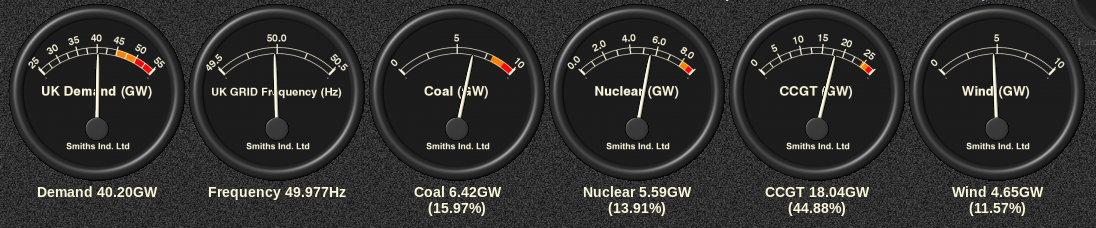
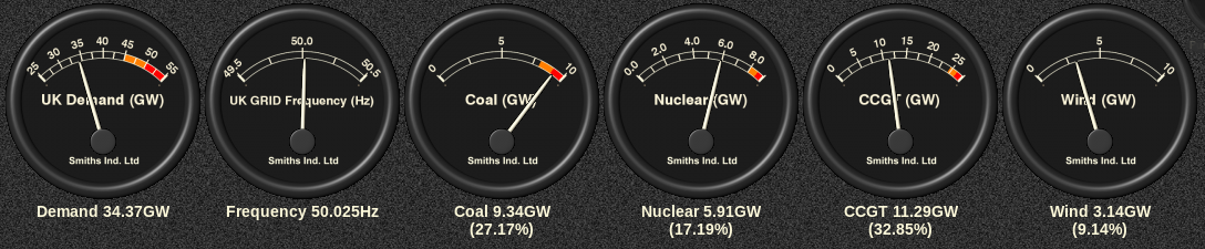
As has been our recent custom, here too is UK plc’s current electricity generation mix courtesy of Gridwatch:

GridWatch-Main-20171210-1030

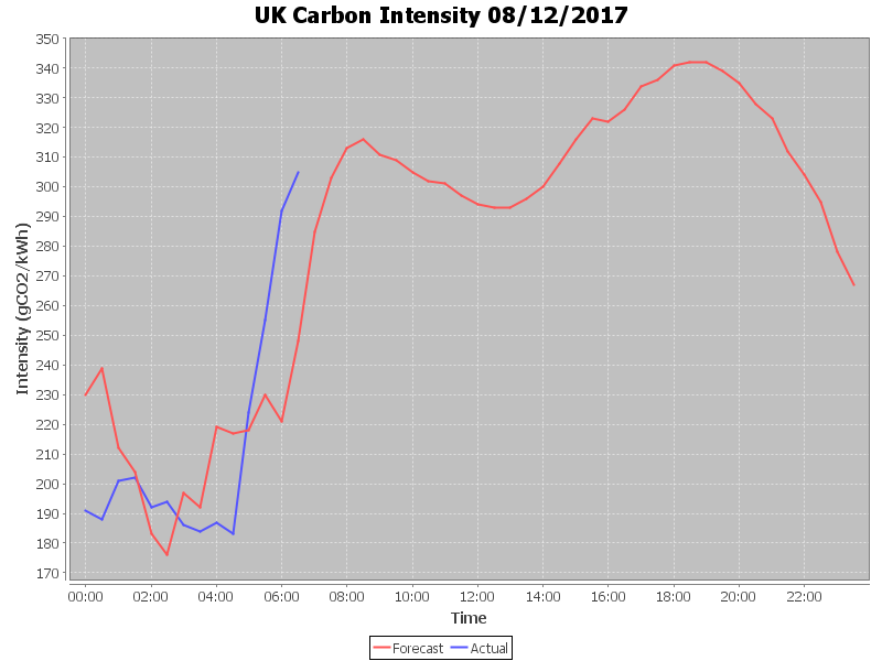
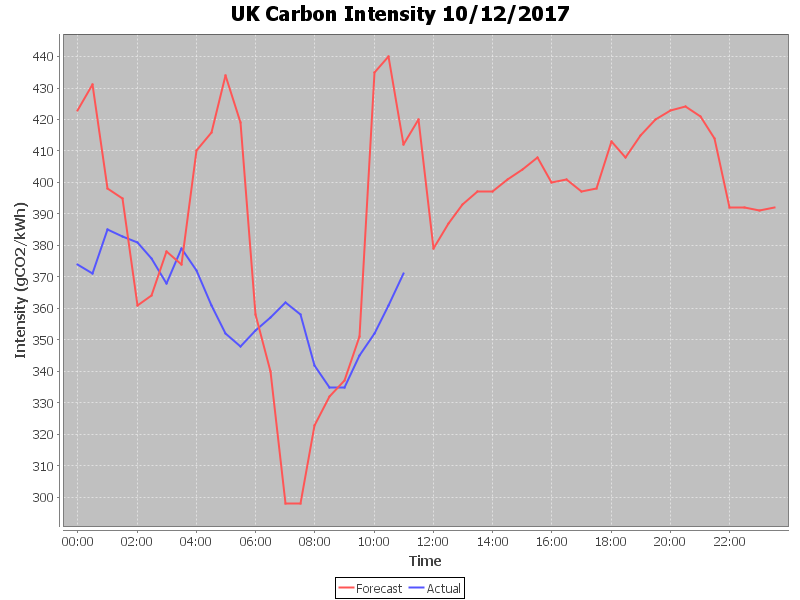
and here is a graph of UK plc’s carbon intensity so far today:

CarbonIntensity_20171210-115134


[Edit – December 11th 10:00]

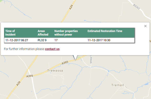
STOP PRESS! We had a brief power cut here at V2G Towers in Tremail this morning. It only lasted for a couple of minutes, and is presumably related to this problem just up the road in Davidstow:

WPD-Davidstow2017-12-11_1000


[Edit – December 11th 17:45]

Suppy has now been restored to the remaining 15 properties in the Davidstow area that have been without mains electricity for most of today.

WPD-Map-2017-12-11_1745

Whilst the number of properties without power across WPD’s network has been reducing today there are still a little under 4,000 remaining, largely in the West Midlands:

WPD-Table-2017-12-11_1745

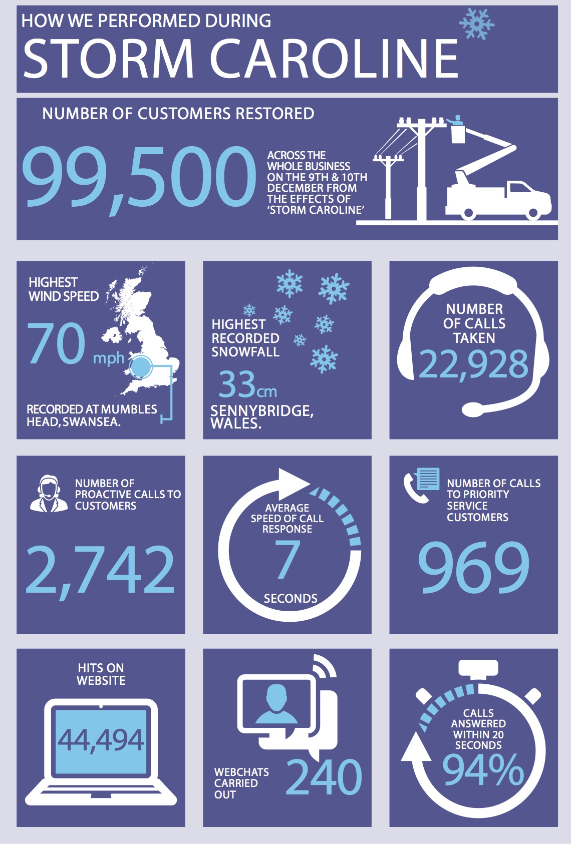
Earlier today WPD issued a press release concerning the effects of Storm Caroline on their distribution network:

Over the weekend we restored just over 99,500 customers, 70,000 of those were in the West Midlands and 15,000 in South Wales which have been the two worst affected areas.

We do not anticipate any further disruption to be caused by the weather conditions based on the latest forecasts we have received.

Since first light this morning, additional resources from other areas have been drafted into the West Midlands to aid with outstanding restorations and repairs.

Over the course of Saturday and Sunday the Contact Centre handled over 20,000 calls with an average speed of response of 7 seconds. 94% of calls were answered in twenty seconds or under. Extra staff worked in both Centres with Ramp Up Rooms opened in our Bristol and Plymouth offices in addition to homeworkers being logged in as well. The transport team also assisted in getting staff into the Contact Centres who were struggling due to the adverse weather conditions.

The British Red Cross were activated twice but were also offered to multiple customers in addition to this who turned down the offer of the support. 969 proactive calls were also made to registered vulnerable customers offering support and advising them when their power supply would be restored.

Below is a snapshot of our performance and associated information covering Saturday 9th and Sunday 10th December.

WPD-Storm-Caroline


[Edit – December 11th 23:55]

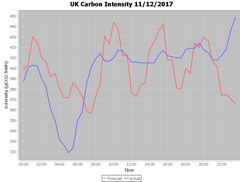
An intriguing carbon intensity graph for the coldest night of the winter so far:

CarbonIntensity_20171211

Coal fired generation is working quite hard at the moment!

GridWatch-Main-20171211-2355


[Edit – December 12th 11:00]

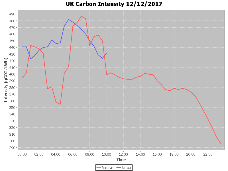
UK plc’s carbon intensity reached a peak of over 480 gCO₂/kWh overnight:

CarbonIntensity_20171212-105540

Meanwhile WPD’s power cut map has finally reverted to something approaching normality:

WPD-Map-2017-12-12_0706

Storm Caroline Power Cuts

Yesterday the UK Met Office issued an amber warning for strong winds caused by Caroline, the third named storm of the winter in this part of the world:

With up to 90 mph gusts expected in the north of Scotland the Met Office pointed out that:

Flying debris is likely and could lead to injuries or danger to life. Some damage to buildings is possible, such as tiles blowing off roofs. Longer journey times and cancellations are likely, as road, rail, air and ferry services may be affected. There is a good chance that power cuts may also occur. Large waves are expected and beach material may be thrown onto coastal roads, sea fronts and properties.

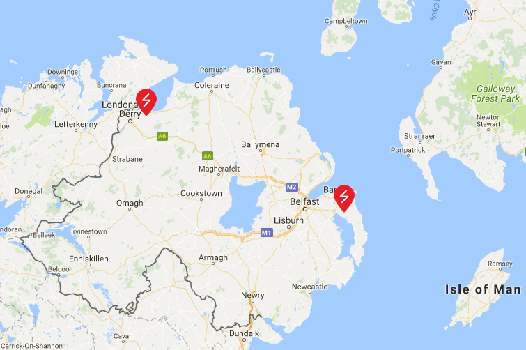
Sticking with those power cuts for the moment, here are the lunchtime maps from the assorted Distribution Network Operators spread across the west and north of the British Isles:
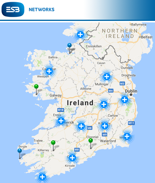
ESB-2017-12-07_1308

NIE-2017-12-07_1309

ENW-2017-12-07_1311

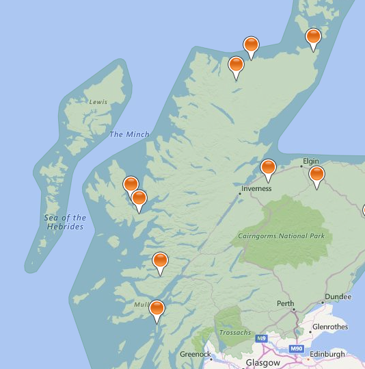
Scottish and Southern Energy Networks:
SSEN-2017-12-07_1312

Scottish Power Energy Networks don’t provide an overview map of the area covered by their network, but they do issue severe weather updates from time to time. Today’s currently states that:

The MET Office has issued a yellow/amber warnings for Thursday 7th December 2017 to much of Scotland. Storm Caroline is expected to bring a spell of very windy weather reaching up to speeds of 80mph over the higher grounds.

Moving into Friday 8th and Saturday 9th, the yellow Met Office warning is still in place and it now covers Scotland, North Wales and Northwest Midlands. The yellow warning continues to bring strong winds but also frequent snow showers of 2-5cm, with 10-20cm in some places.

Icy surfaces are also likely to be an additional hazard, especially overnight. The heaviest and most frequent snow showers will progressively become confined to northeast Scotland during Saturday.

We have not yet seen any impact of Storm Caroline on our Network and as such we are presently working as business as usual, however, we will continue to monitor the weather situation closely.

Scottish and Southern do however provide timely news updates. The lunchtime edition reports that:

As forecast, gale-force winds reached the Western Isles from the early hours of this morning, with wind gusts in excess of 85mph recorded. SSEN’s network has stood up well to the initial impact and power has been safely restored to over 3,900 customers, mainly on the Western Isles and north-west Highlands, with around 780 homes currently without power as of 12pm today.

The full impact of Storm Caroline has not yet been felt across much of SSEN’s network region and it is expected there will be further faults throughout the day as the weather front continues to track across the north Highlands, into the Moray Firth and up to Orkney. Winds are expected to peak between midday and 6pm this evening with gusts of 70 -95mph forecast. Shetland is expected to feel the full force of Storm Caroline from midnight tonight through to lunchtime on Friday.

With snow and falling temperatures forecast for Friday, there is also a risk of line icing, where snow accumulates and freezes on the overhead electricity network, which can result in damage due to the sheer weight of accumulated snow and ice. Infrequent lightning also remains a risk.


[Edit – December 7th 18:00]

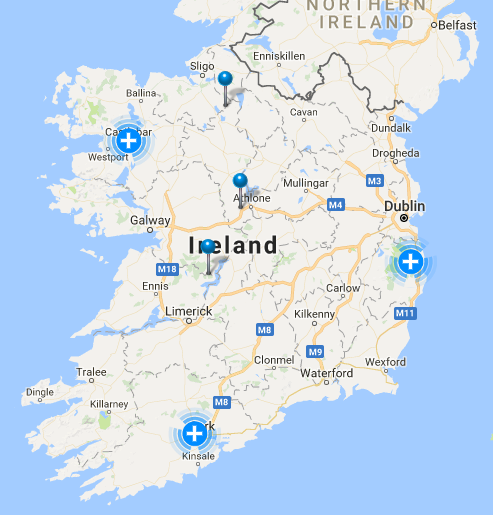
Firstly here are the tea time power cut maps:
ESB-2017-12-07_1751

NIE-2017-12-07_1753

ENW-2017-12-07_1754

SSEN-2017-12-07_1757

SPEN still haven’t updated their “Severe weather update” from yesterday.

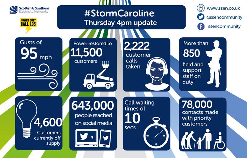
SSEN have issued a 4 PM update, which reads as follows:
SSEN-News-2017-12-07-1600

As forecast, gale-force winds have tracked slowly across SSEN’s network region, starting in the Western Isles in the early hours of the morning with the storm moving from west to east throughout the day. Wind gusts of 95mph have been recorded at Burgar Hill in Orkney, with widespread gusts in excess of 80mph observed across the north of Scotland.

SSEN’s network continues to stand up well to the impact of Storm Caroline and power has been safely restored to over 11,500 customers. The main areas affected have been the Western Isles, north-west Highlands, Caithness, Moray, north-east Aberdeenshire, Orkney and Shetland.

As of 4pm, around 4,600 homes remain without power, mainly in Caithness, Orkney and Shetland. All faults are resourced with teams working to restore power, where it is safe to do so.

Wind speeds are forecast to subside for most parts from around 6pm this evening, with the exception of Shetland which is expected to continue to feel the effects of Storm Caroline through to tomorrow morning.

With snow and falling temperatures forecast for Friday, SSEN will remain on Yellow Alert due to the risk of line icing, where snow accumulates and freezes on the overhead electricity network, which can result in damage due to the sheer weight of accumulated snow and ice. A risk of lightning also remains.

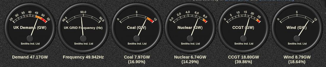
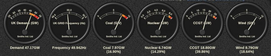
Whilst the far north of Scotland may be experiencing very strong winds, further south wind turbines across the nation will be spinning furiously, so lets now take a look at the mix of UK electricity generation at the moment, courtesy of Gridwatch:
GridWatch-Main-20171207-1720

We’re currently experiencing the usual early evening peak in demand and we’re also experiencing a bit of a cold snap at the moment:

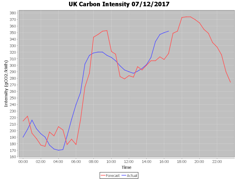
Hence there’s also an “amber warning” for electricity demand this evening, with wind contributing almost 9 GW of the required 47.17 GW. Here’s how that looks expressed as UK plc’s “Carbon intensity“:
CarbonIntensity_20171207-053211


[Edit – December 7th 22:30]

Our suite of power cut maps reveal that the worst effects of Storm Caroline are now confined to the far north east of Scotland, including Orkney and Shetland:
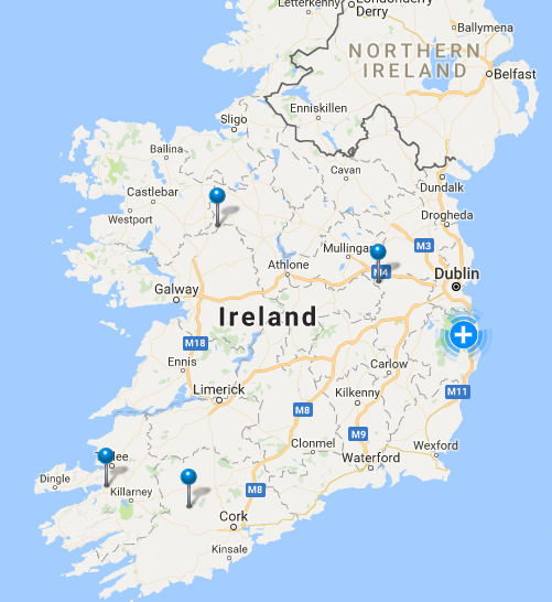
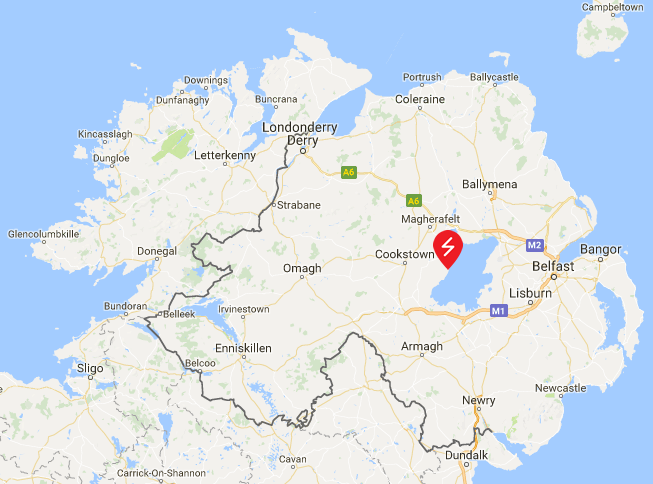
ESB-2017-12-07_2226

NIE-2017-12-07_2227

ENW-2017-12-07_2229

SSE-2017-12-07_2231

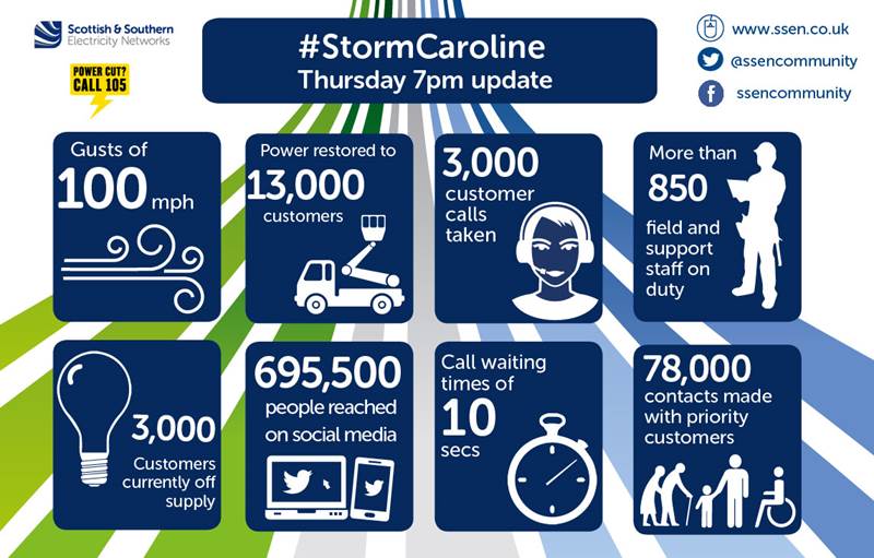
Scottish and Southern have issued another updates:
SSEN-News-2017-12-07-1900

From the early hours of this morning, gale-force winds have battered the north of Scotland, tracking slowly across SSEN’s network region from west to east throughout the course of the day. Over the last few hours, Shetland has borne the brunt of Storm Caroline, with wind gusts of over 100mph recorded at Gremista.

Power has been safely restored to over 13,000 customers across SSEN’s network, the main areas affected being the Western Isles, north-west Highlands, Caithness, Moray, north-east Aberdeenshire, Orkney and Shetland. With wind speeds now starting to subside for most areas it is anticipated the vast majority of customers will be restored this evening. As of 7pm, there are currently 3,000 customers still off supply, 1,300 of which are in Shetland.

Due to the continued severity of the wind speeds experienced in Shetland, which are forecast to continue through to tomorrow morning, and access issues affecting a small number of customers on Orkney, it is likely that some homes will remain off supply overnight. SSEN’s teams remain on standby and will carry out repairs as soon as it is safe to do so.

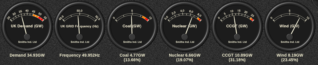
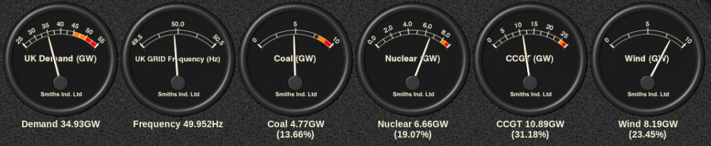
As the evening has progressed UK electricity demand has dropped as forecast, and the generation mix now looks like this:
GridWatch-Main-20171207-2250


[Edit – December 8th 07:00]

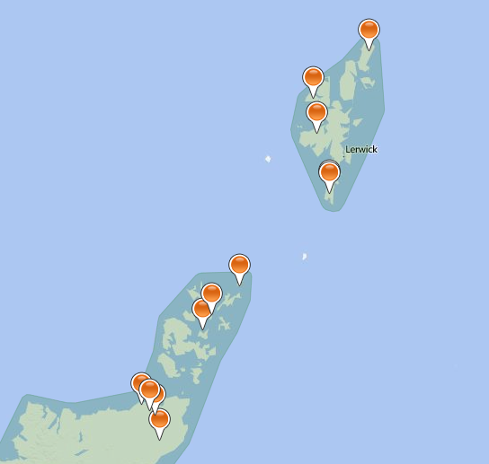
There’s still a wind warning in place for the Northern Isles:

Consequently Scottish and Southern’s map of power cuts in the area still looks like this at the moment:
SSEN-2017-12-08_0657

Scottish and Southern issued a further update on Storm Caroline late last night:

Following the impact of Storm Caroline, which has seen prolonged gale force winds affecting many areas across the north of Scotland, SSEN has now successfully reconnected the vast majority of homes affected, with power safely restored to over 14,000 customers. The main areas affected have been the Western Isles, north-west Highlands, Caithness, Moray, north-east Aberdeenshire, Orkney and Shetland.

Due to the persistent and severe nature of wind speeds still being felt across parts of Caithness, Orkney and Shetland, coupled with difficulty gaining access to faults, as of 10pm this evening SSEN has taken the decision to stand down its field based teams in these locations for safety reasons and around 500 customers will remain off supply overnight.

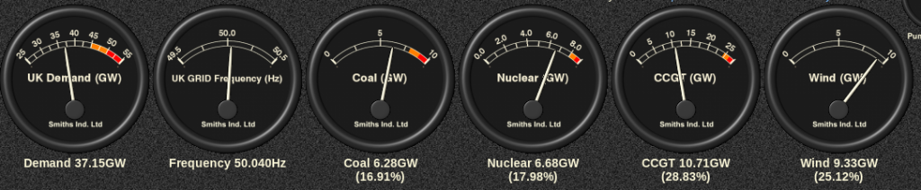
Here’s the UK’s generation mix this morning:
GridWatch-Main-20171208-0700

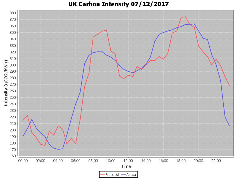
and here’s the final UK plc carbon intensity graph for yesterday:
CarbonIntensity_20171207

plus today’s thus far:

CarbonIntensity_20171208-070858


[Edit – December 8th 15:00]

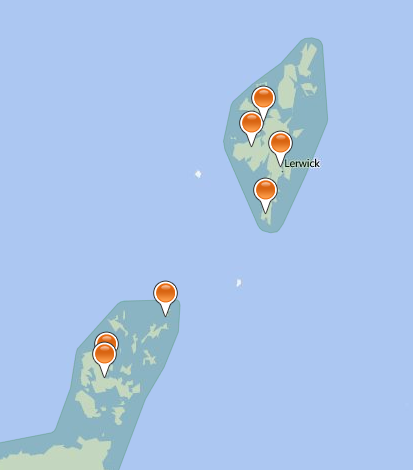
Scottish and Southern’s map of power cuts still shows several outages this afternoon:
SSEN-2017-12-08_1452

In their latest bulletin they say that:

SSEN’s teams continue to make good progress to restore power to the last remaining customers affected by the impact of Storm Caroline, which brought sustained gale force winds to many areas across the north of Scotland. Throughout the course of the event, SSEN has successfully reconnected power to over 18,000 homes. The main areas affected have been the Western Isles, north-west Highlands, Caithness, Moray, north-east Aberdeenshire, Orkney and Shetland.

As of 2.30pm, just 250 homes remain off supply, with the main areas still affected being Orkney and Shetland. All faults have been resourced and SSEN anticipates all homes will have power restored by this evening.

To support efforts to restore power to those homes who remained off supply overnight, SSEN has moved additional teams to the areas affected and is also working closely with its resilience partners to help overcome challenges with gaining access to faults as a result of cancellations to local ferry services and road closures due to snow. This includes working in coordination with the RNLI, who are providing a helicopter to get additional teams and resource to South Ronaldsay, Orkney.

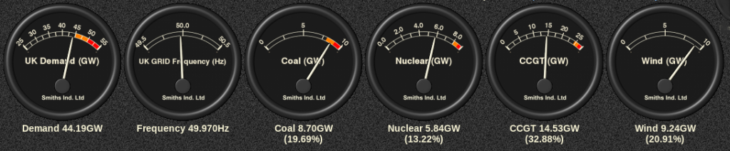
Here’s the current generation mix:
GridWatch-Main-20171208-1430


[Edit – December 8th 18:15]

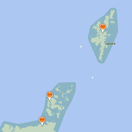
Scottish and Southern Electricity Networks say they:

Have now returned to business as usual but we will continue to monitor conditions and are well prepared to respond to whatever other challenges the Scottish weather has in store for us this winter.

Their current power cut map confirms that:
SSEN-2017-12-08_1802

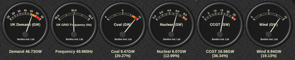
Much like yesterday, this evening’s demand is back up in the amber zone:
GridWatch-Main-20171208-1815


[Edit – December 9th]

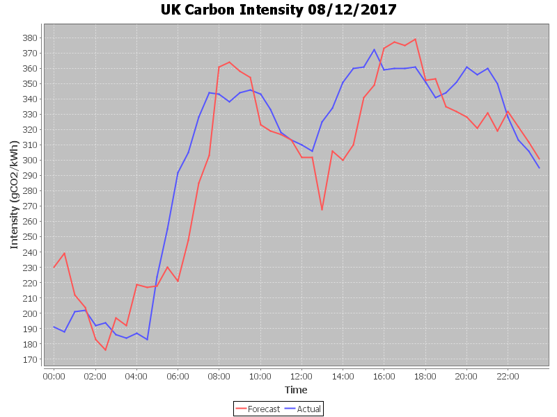
Here is the final UK plc carbon intensity graph for yesterday:
CarbonIntensity_20171208

Storm Brian Power Cuts

Less than a week after ex Hurricane Ophelia battered Ireland another named storm is due to arrive overnight. This one is more conventional than Ophelia, since Brian never was a Hurricane. However despite that he still packs a considerable punch. This time around Met Éireann have issued an orange wind warning for coastal areas in the south of Ireland:
Wind Warning for Coasts of Mayo, Galway, Clare, Kerry, Cork, Waterford and Wexford

Southeast winds of mean speeds 55 to 65km/h with gusts of 90 to 110km/h, will veer west or northwest and strengthen further during the night, reaching orange level with mean speeds of 65-80 km/h with gusts 110-130 km/h. Winds will ease to yellow warning level during Saturday evening.

Issued: Friday 20 October 2017 12:16
Valid: Friday 20 October 2017 22:00 to Saturday 21 October 2017 22:00

Meanwhile the UK’s Met Office has issued a yellow wind warning across much of southern England:

Brian-20171019+2d

A swathe of strong south or southwesterly winds reaching parts of Wales and southwest England will steadily transfer east and north during the morning. Later in the afternoon winds will gradually turn westerly and wind inland will start to slowly ease. Meanwhile, in western and southern coastal areas winds will start to slowly ease later in the evening. Gusts of 45 to 55 mph are expected widely within the warning area with gusts of 60 to 70 mph along exposed southern and western coastal areas. These are expected to coincide with high tides, leading to locally dangerous conditions around coastal areas in western and southern parts of England and Wales.

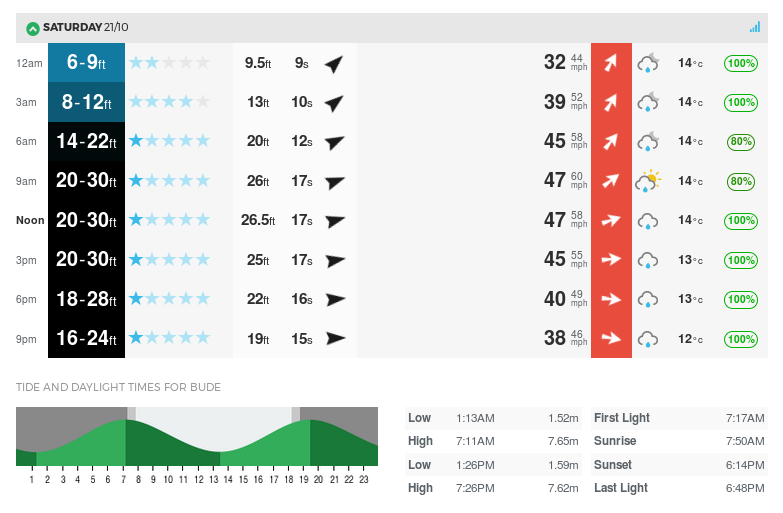
The local surf forecast for North Cornwall from Magic Seaweed reveals even bigger waves than Ophelia produced:

WidemouthSurf-20171020+1d

Meanwhile according to ESB Networks:

ESB Networks have now continued to restore power this morning, with power now restored to 343,000 families, farms and businesses. Approximately 42,000 customers remain without supply.

​The worst impacted areas are in the environs of Enniscorthy, Wexford town, New Ross, Bandon, Dunmanway and Fermoy.

Assisted by contractors, crews from Northern Ireland and overseas utilities, as well as the army and air corps, ESB Networks will continue restorations to every last family, farm and business until their lives are back to normal.

A Met Éireann Status Orange wind warning has been issued for seven coastal counties, including Cork and Wexford, will hamper restoration efforts. Should the weather conditions worsen further, our crews will be stood down until it is safe to resume repairs again. Winds speeds up to 130 km/h will cause outages to customers in Mayo, Galway, Clare, Kerry, Cork, Waterford and Wexford on Saturday.


[Edit – October 21st 10:00]

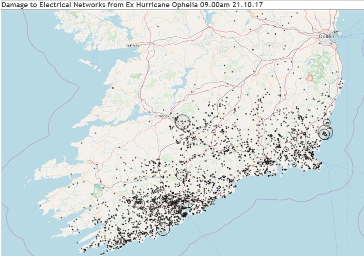
This morning ESB Networks have released a power cut heat map revealing how far their restoration efforts after Storm Ophelia managed to get before Storm Brian arrived:

ESB Networks have now restored ​363,000 homes, farms and businesses who lost power supply due to the damage inflicted by ex-hurricane Ophelia. Our crews are continuing to work to restore the 22,000 homes, farms and business that are still without supply.

The locations of these homes, farms and businesses are highlighted on the heat map below.

ophelia-heat-map-20171021-0900

Our crews will work to restore everyone as long as it is safe to do so. We are acutely aware of how difficult the situation is for all of customers who remain without power.

Power cut numbers are now rising again. By our reckoning there are currently just under 30,000 “homes, farms and businesses” without power across southern Ireland.


[Edit – October 21st 11:00]

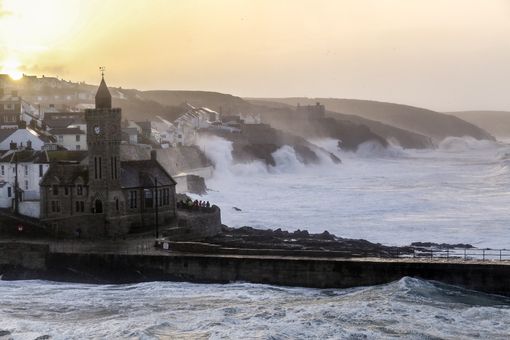
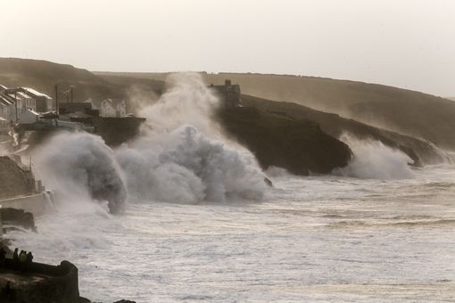
A couple of pictures from Porthleven by Cornwall Live’s Sally Adams:

Storm-Brian-Porthleven-1

Storm-Brian-Porthleven-2


[Edit – October 22nd]

In this morning’s update ESB Networks report that:

While Storm Brian hampered power restoration following Storm Ophelia and caused additional outages on the system, work continued as and when safe to do so.

10,000 homes, farms and business remain without power this morning, down from 385,000 at the peak on Monday. Whilst Storm Brian caused additional problems good progress was made and the total number without power this morning is now 10,000.

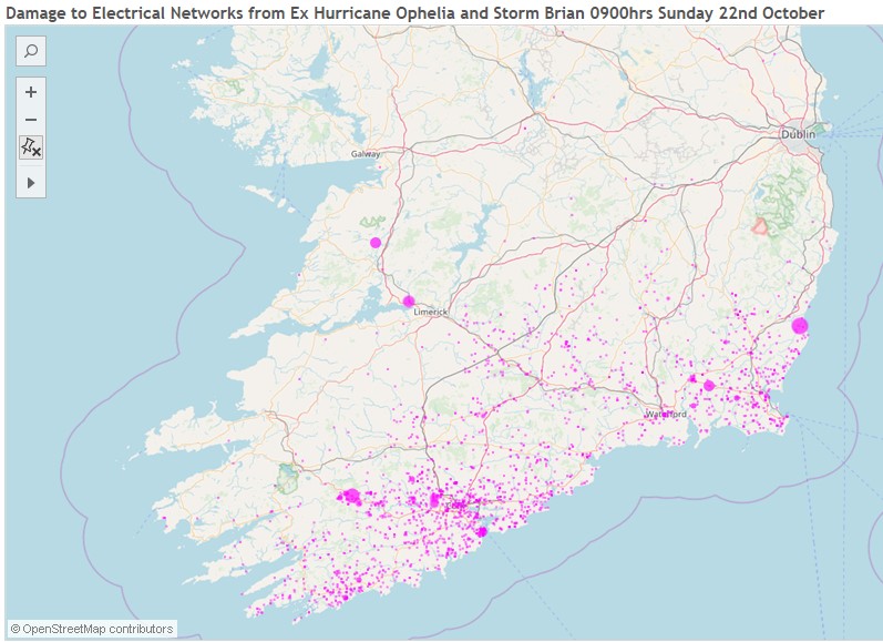
ophelia-heat-map-20171022-0900


[Edit – October 22nd PM]

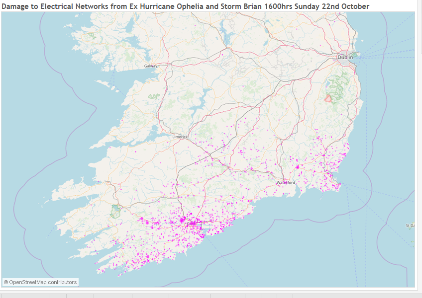
This evening ESB Networks report that:

ESB Networks continue to restore electricity supply in the worst impacted areas of Counties Cork and Wexford. Approximately 6,000 customers are currently without power, a number of which are due to Storm Brian.

Here is an illustration of the remaining homes, farms and businesses that we are working to restore.

ophelia-heat-map-20171022-1600