Hurricane Sally Heads for Louisiana

Louisiana still hasn’t recovered from the damage caused by the passage of Hurricane Laura last month. Here’s how the state’s power outage map looks this morning (UTC):

Now yet another storm is heading for the coast of the Gulf of Mexico. Tropical Storm Sally is forecast to increase in strength to hurricane force before crossing the coast further to the east than Laura:

According to the National Hurricane Center:

CENTER LOCATED NEAR 28.2N  86.2W AT 14/0300Z
ESTIMATED MINIMUM CENTRAL PRESSURE  996 MB
MAX SUSTAINED WINDS  50 KT WITH GUSTS TO  60 KT.

FORECAST VALID 14/1200Z 28.6N  87.3W
MAX WIND  60 KT...GUSTS  75 KT.

FORECAST VALID 15/0000Z 29.0N  88.3W
MAX WIND  70 KT...GUSTS  85 KT.

FORECAST VALID 15/1200Z 29.4N  89.0W
MAX WIND  80 KT...GUSTS 100 KT.

FORECAST VALID 16/0000Z 30.3N  89.4W...INLAND
MAX WIND  70 KT...GUSTS  85 KT.

[Edit – September 16th 10:00]

Hurricane Sally is currently making landfall further east than originally forecast:

Here’s the NHC’s current forecast track for Sally:

and their latest estimate of Sally’s strength:

NOAA buoy 42012, located about 50 miles southeast of Mobile, 
Alabama, recently reported a sustained wind of 71 mph (115 km/h) and 
a pressure of 970.9 mb inside the eastern portion of Sally's eye.

SUMMARY OF 300 AM CDT...0800 UTC...INFORMATION
----------------------------------------------
LOCATION...30.0N 87.8W
ABOUT 50 MI...75 KM SW OF PENSACOLA FLORIDA
ABOUT 55 MI...85 KM SE OF MOBILE ALABAMA
MAXIMUM SUSTAINED WINDS...105 MPH...165 KM/H
PRESENT MOVEMENT...NNE OR 020 DEGREES AT 3 MPH...5 KM/H
MINIMUM CENTRAL PRESSURE...965 MB...28.50 INCHES

So far Alabama has suffered the most, with almost 200,000 power cuts currently.

Hurricane Irma Power Outages

The power outages in Texas caused by the recent passage of Hurricane Harvey haven’t all been repaired yet. Now a whole lot more people next door in Florida are finding themselves without electricity thanks to the arrival of Hurricane Irma. According to the latest update on Irma from the United States’ National Hurricane Center:

The center of Hurricane Irma made landfall at Cudjoe Key in the
lower Florida Keys at 9:10 am EDT. A gust to 106 mph (171 km/h)
was just reported at the National Key Deer Refuge in Big Pine Key.

SUMMARY OF 910 AM EDT…1310 UTC…INFORMATION
———————————————-
LOCATION…24.7N 81.5W
ABOUT 20 MI…30 KM ENE OF KEY WEST FLORIDA
MAXIMUM SUSTAINED WINDS…130 MPH…215 KM/H
PRESENT MOVEMENT…NNW OR 330 DEGREES AT 8 MPH…13 KM/H
MINIMUM CENTRAL PRESSURE…929 MB…27.43 INCHES

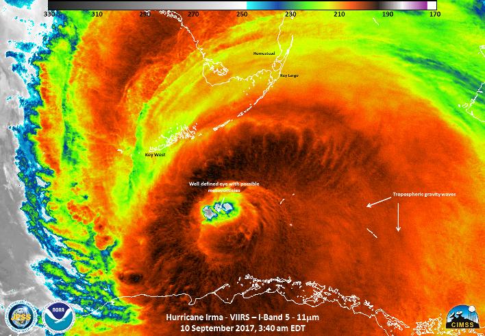
Here’s how Irma looked from the Suomi satellite whilst crossing the Straits of Florida:

and here’s a NOAA video showing Irma making landfall at Cudjoe Key:

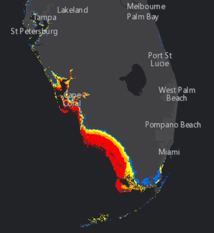
This is the National Hurricane Center’s storm surge forecast for the next three days:

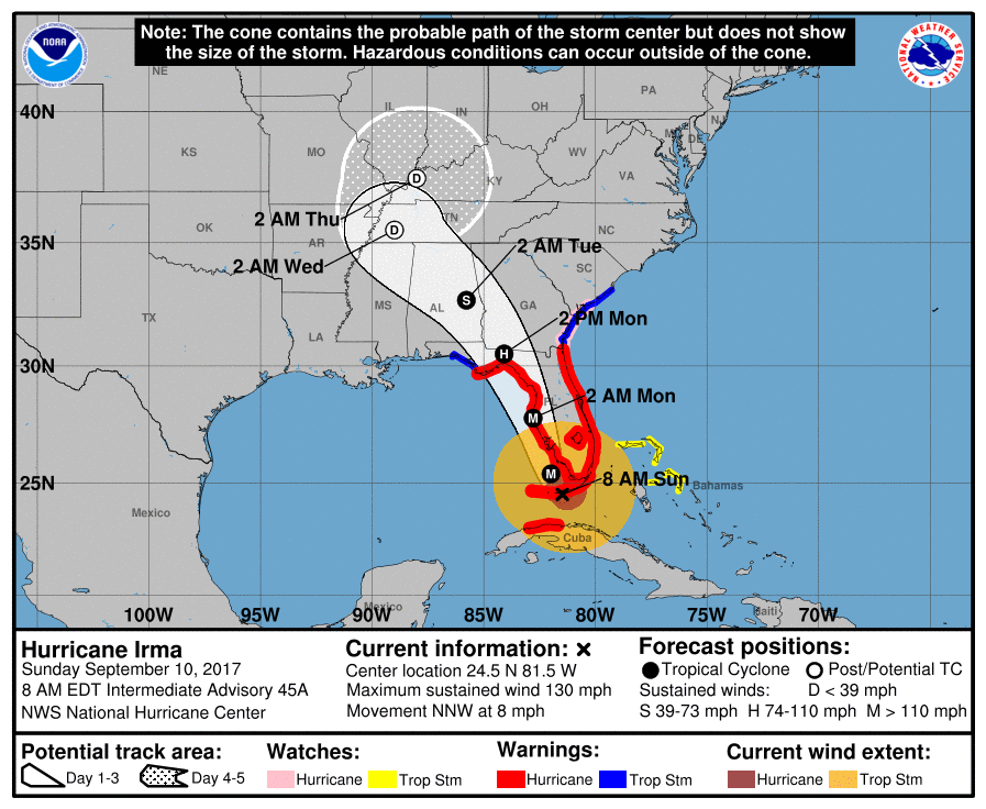
The red area represents a greater than 10% chance of a surge of nine feet and over. Finally, for the moment at least, here’s Irma’s current forecast track from slightly earlier in the day:

Already over 750,000 premises across Florida are without electric power.


[Edit – September 11th]

Here’s a video from ABC about the effects of Hurricane Irma on Florida’s electricity distribution infrastructure:

Another video in which Rob Gould of Florida Power and Light says:

What we will see on the west coast is a wholesale rebuild of our electric grid.

At 9 AM this morning British Summer time the lights have started going out in Georgia, and over 4.5 million premises across Florida are without electric power.


[Edit – September 11th PM]

Florida Governor Rick Scott reports on the impact of what is now Tropical Storm Irma:

There are now over 6.5 million premises across Florida, Georgia and the Carolinas without electric power.