California ISO Anticipates Another Weekend Heatwave

Following the recent series of rolling blackouts in California, we got wind of this a couple of day ago via Twitter:

Our suspicions have since been confirmed:


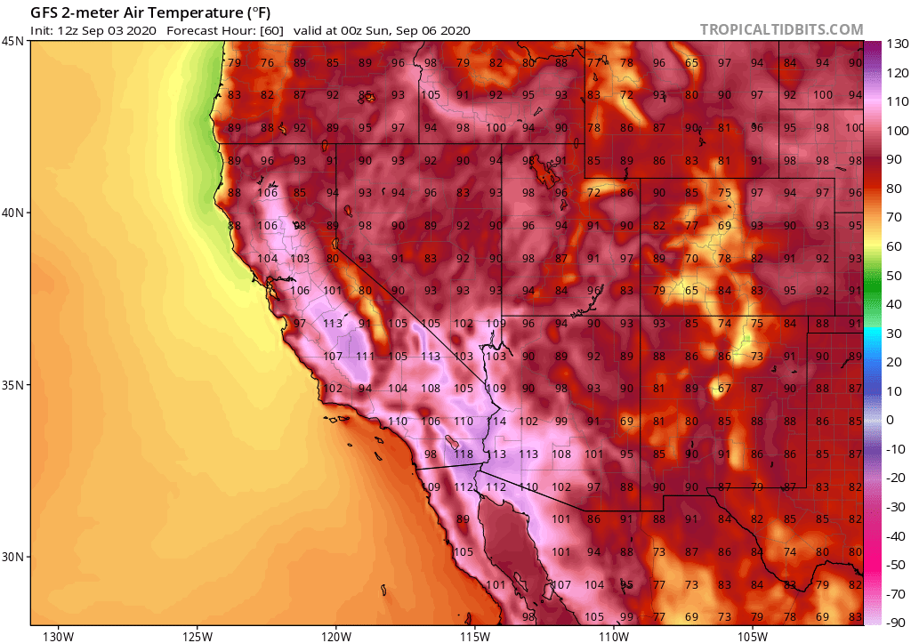
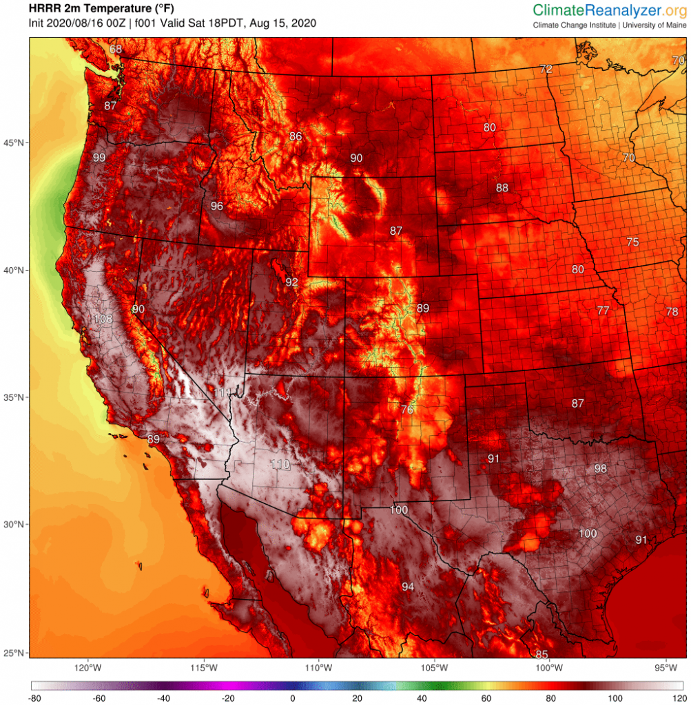
Here is the current GFS forecast for 00:00 UTC on Sunday:

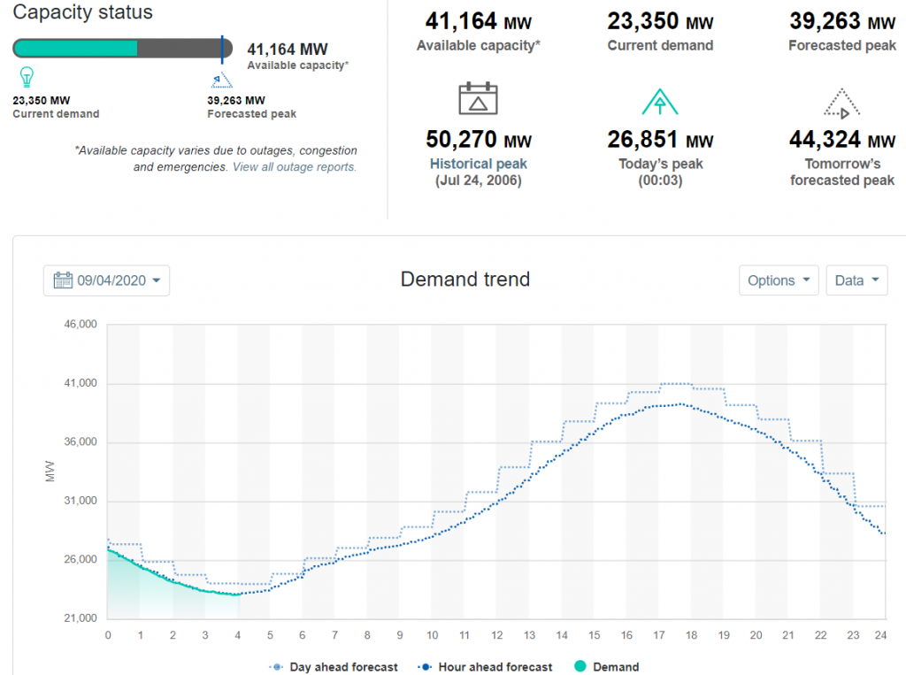
And here is CAISO’s forecast demand for today:

Continue reading →

Storm Francis Follows Hot on the Heels of Ellen

At the moment I’m too busy writing about the seemingly never ending sequence of power cuts due to “extreme weather” events to wax lyrical about developments in vehicle-to-grid technology!

In California the heat wave is over and rolling blackouts a thing of the past, for the moment at least. However the wildfires continue, and the Lawrence Berkeley
National Laboratory is temporarily closed:

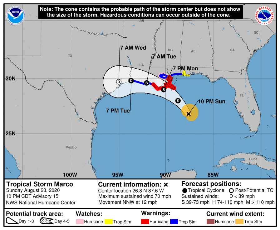
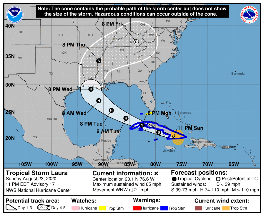
Meanwhile in the Gulf of Mexico tropical storms Laura and Marco are simultaneously heading for the Louisiana coast. Laura is forecast to be a hurricane by the time she gets there, with Marco being merely an ex hurricane by landfall later today.

Now this morning comes news that hot on the heels of Storm Ellen last week, which caused many tens of thousands of properties in Ireland to suffer a power cut, the United Kingdom’s Meteorological Office has named Storm Francis:

Further power cuts are expected in the near future, on the shores of both the Gulf of Mexico and the North Atlantic! Here is the local wind forecast for the V2G Group office in (Silic)Inny Valley, North Cornwall, courtesy of MeteoCiel:

Please note that this forecast is for the peak of the post 2020 Covid-19 lockdown Cornish staycation season, not the middle of winter!


[Edit – August 25th 08:00]

As the winds from Storm Francis increase over South West England let’s take a quick look at current and projected electricity generation for today:

Plus today’s Octopus Energy Agile electricity tariff for South West England:

and the United Kingdom’s carbon intensity forecast:

[Edit – August 25th 22:00]

Here’s an image of Storm Francis over the British Isles recorded earlier today by the Suomi satellite:

Marco and Laura Gang Up On Gulf Coast

Only last week we were following power cuts caused by both a heat wave in California and hurricane force winds in Ireland thanks to the extratropical cyclone dubbed Storm Ellen by Met Éireann. This week we already have two hurricanes heading for the United States coast in the Gulf of Mexico, where a significant storm surge and numerous power outages are now expected.

The sustained wind speeds of Hurricane Marco have just dropped below the Saffir-Simpson scale category 1 threshold of 74 miles per hour. However storm surge and hurricane warnings are still in place for the Gulf coast of Lousiana:

A STORM SURGE WARNING IS IN EFFECT FOR.... 
* MORGAN CITY LOUISIANA TO OCEAN SPRINGS MISSISSIPPI
* LAKE BORGNE
A HURRICANE WARNING IS IN EFFECT FOR...
* MORGAN CITY LOUISIANA TO THE MOUTH OF THE PEARL RIVER

Marco is due to make landfall later this evening. Meanwhile Tropical Storm Laura, currently crossing Cuba, is forecast to strengthen as she crosses the Gulf before making landfall at hurricane strength on Wednesday night, in Louisiana once again:

FORECAST VALID 27/0000Z 29.2N  92.4W
MAX WIND 90 KT...GUSTS 110 KT.
50 KT... 50NE 40SE 30SW 40NW.
34 KT...100NE 100SE 50SW 80NW.

Significant damage to the electricity distribution infrastructure in the southern USA is expected. Yet again we are compelled to wonder if many of the anticipated power outages could have been prevented if areas of the United States vulnerable to hurricane damage already possed significant numbers of vehicle-to-grid capable electric vehicles and bidirectional charging stations?

Continue reading →

Bad Weather Batters Global Electricity Grids

Over on the eastern side of the Pacific Ocean there has been a summer heat wave in California:


As a consequence air conditioning works hard, electricity demand goes up, and over the last few days there have been some rolling blackouts across the Golden State. According to the New York Times on August 16th:

As temperatures began to rise in California on Friday and again on Saturday, the manager of much of the state’s electric grid called on utilities to cut power to hundreds of thousands of customers.
But the rolling blackouts on those days left some of the state’s energy experts bewildered. They said that the utilities had plenty of power available and that the blackouts weren’t necessary. The grid’s capacity may be tested in coming days as temperatures are forecast to reach into the triple digits again in some places.

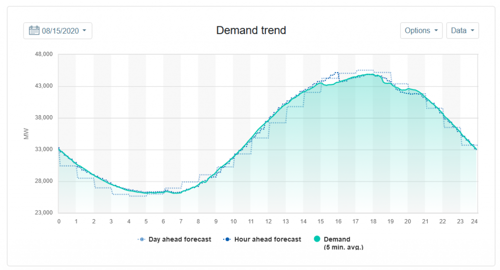
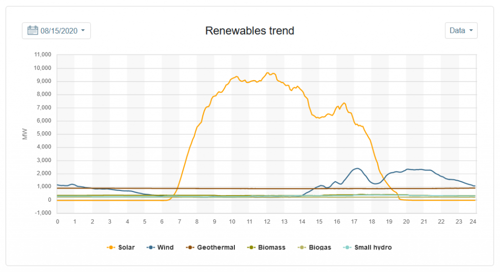
The grid’s capacity was indeed tested in the following days. It’s not clear why the California Independent System Operator (CAISO for short) didn’t issue a call for a voluntary “Flex Alert” on August 15th, but the ultimate consequence was some power cuts. Here’s CAISO’s record of electricity demand and renewable generation that day:

Continue reading →

The Lights Go Out Again at V2G Towers

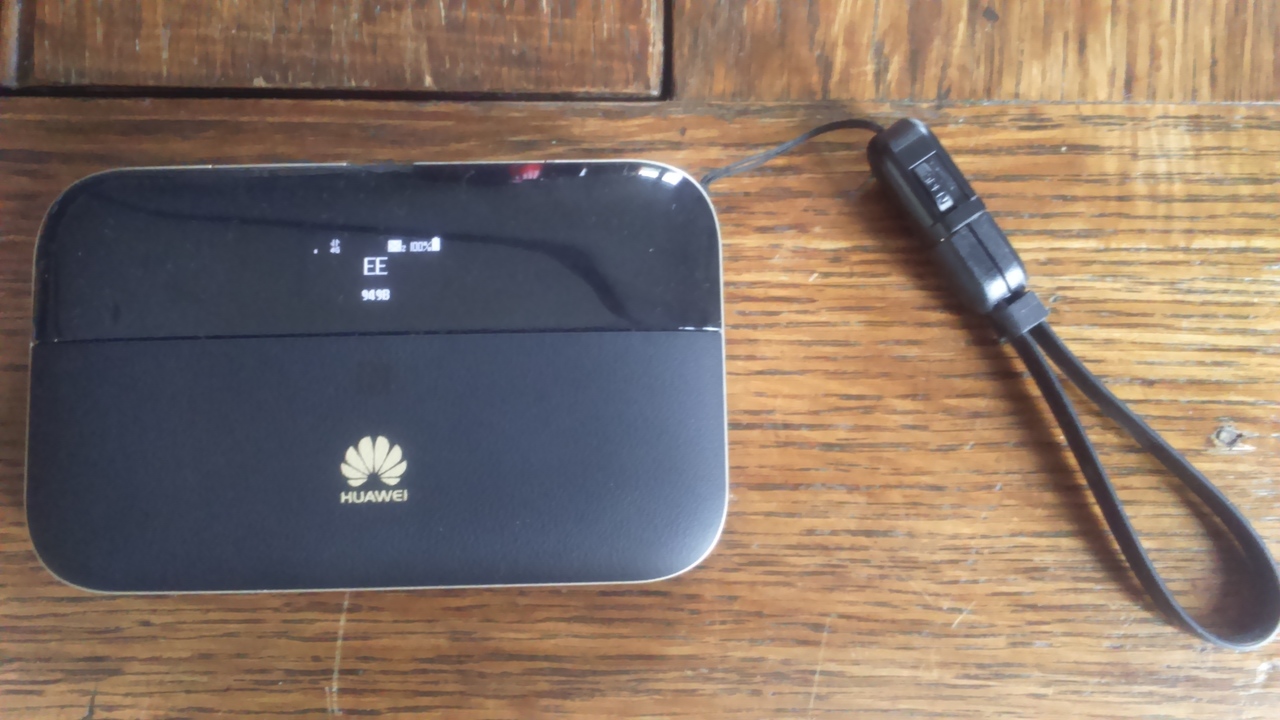
Our lights went out at 11:33 this morning, together with our telephone and “fibre to the premises” BT broadband. Fortunately we have backup for the latter two in the form of the by now ubiquitous mobile phones and this Huawei E5885L 4G mobile WiFi hotspot:

DSC_0007
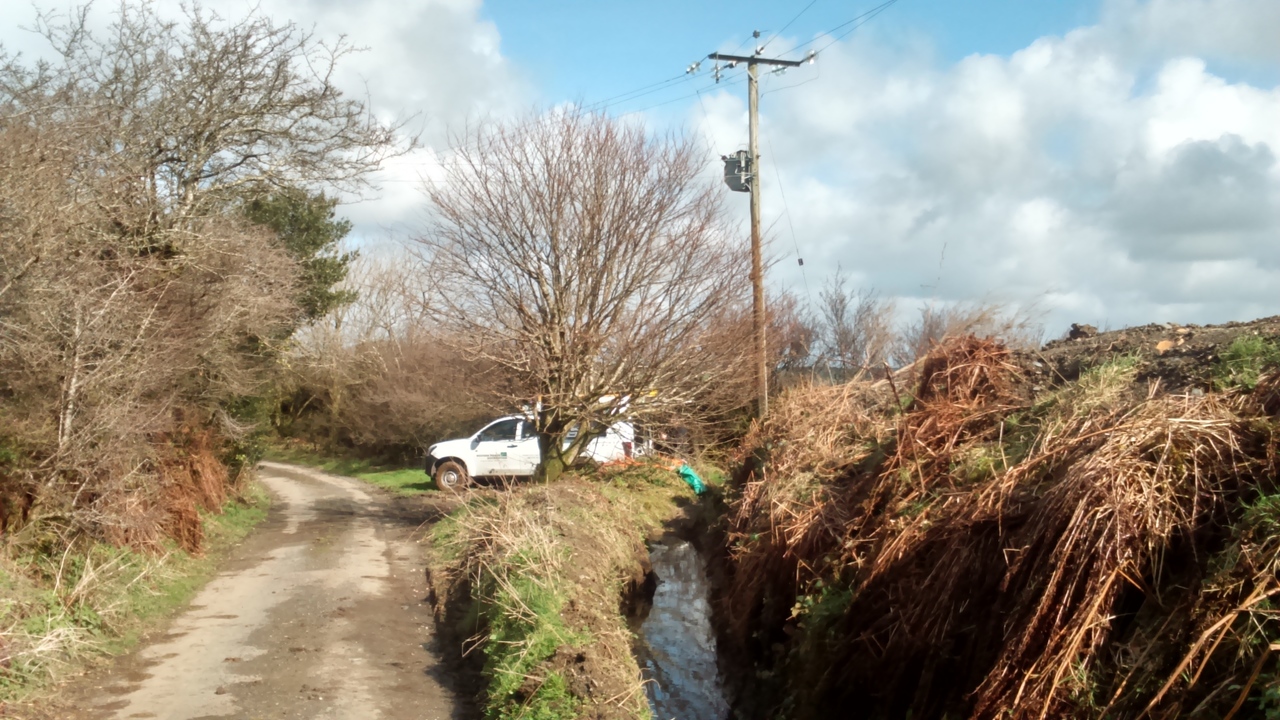
The cause of the problem was an 11 kV cable that had become detached from an insulator and was dangling lower than designed:

DSC_0014

DSC_0021

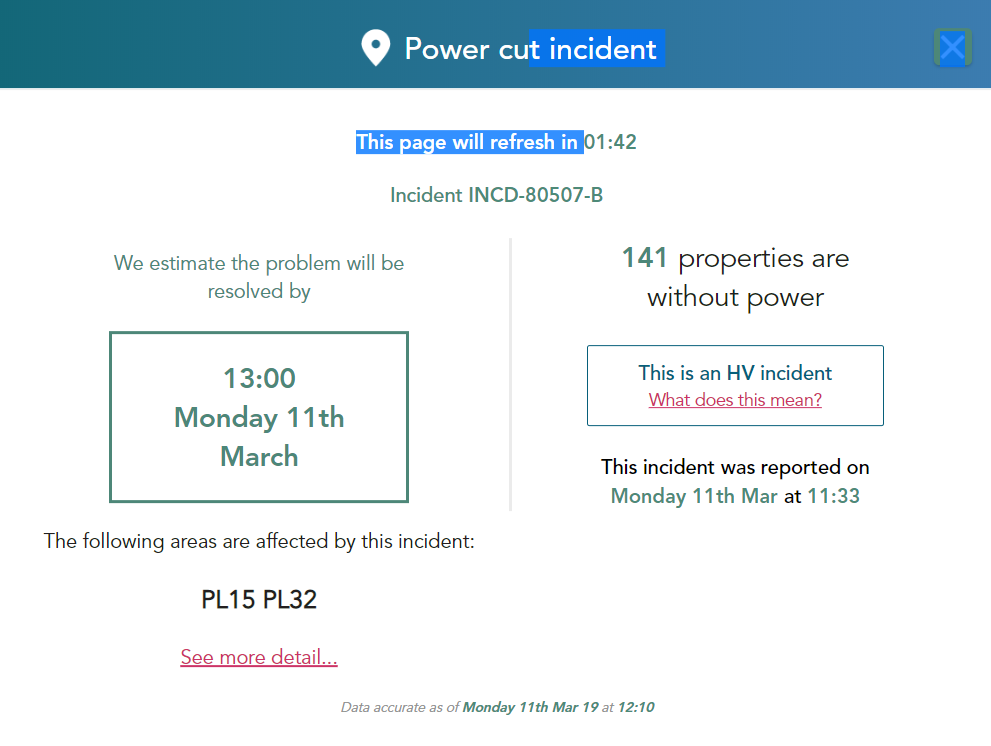
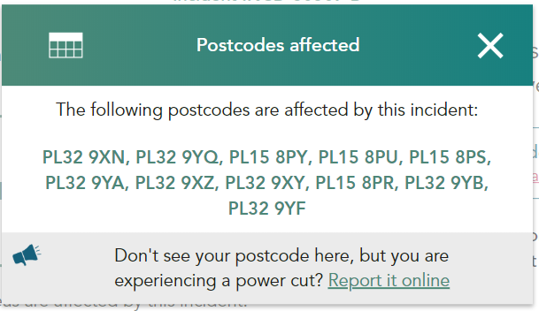
Initially we were one of 141 properties without power:

2019-03-11_1230-WPD

2019-03-11_1228-WPD

2019-03-11_1229-WPD

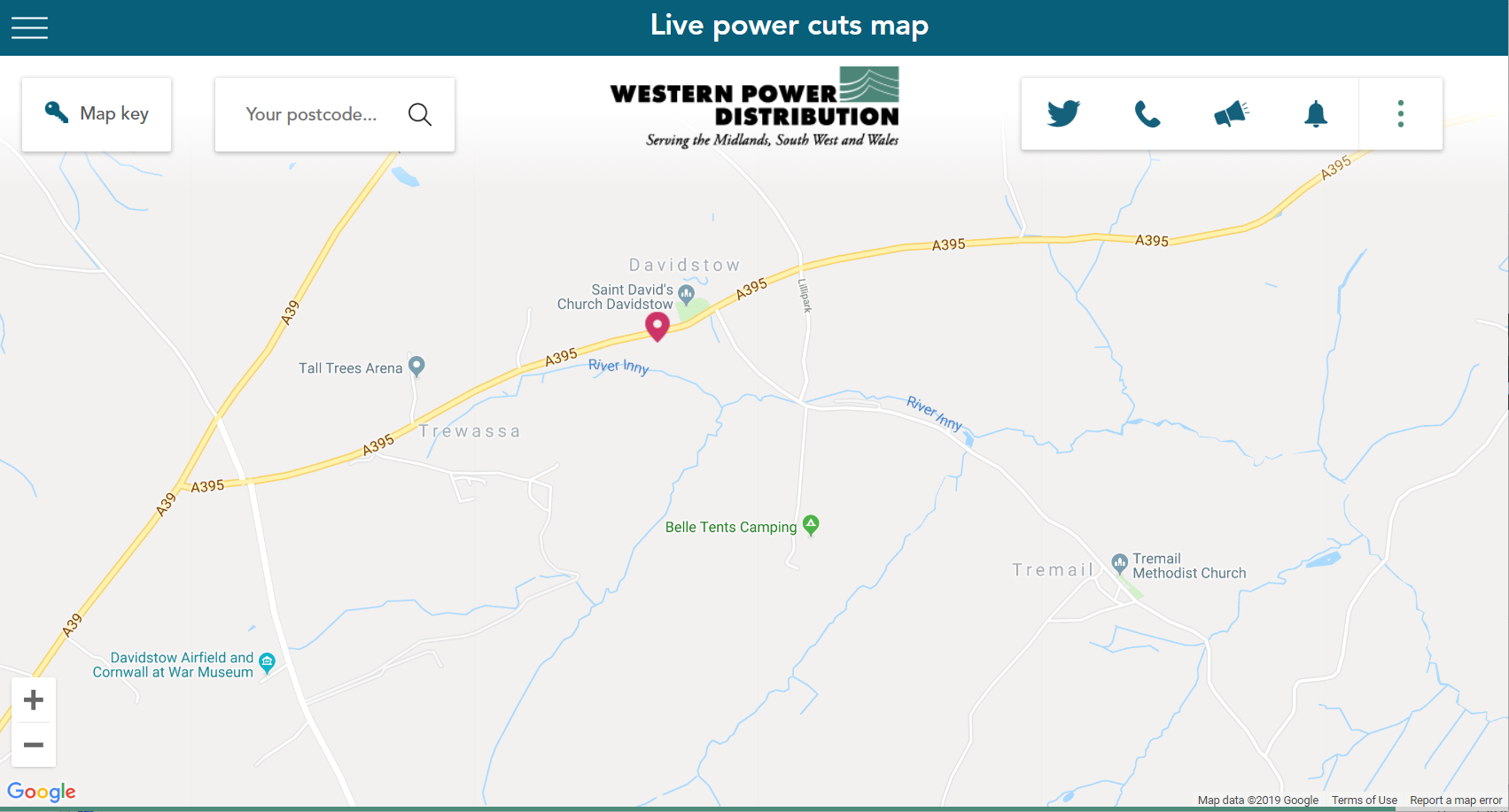
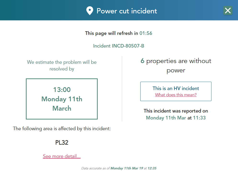
By 12:20 our power came back on since WPD’s engineers had arrived and isolated a small section of their distribution grid just up the hill from here leaving just 6 properties on the edge of Davidstow Moor without mains electricity:

2019-03-11_1250-WPD

They had their power restored somewhat later, at 13:50:

2019-03-11_1434-WPD

We really must persuade our current landlord to let us install a 3 phase supply and full strength V2G technology to enable us to weather such storms much more smoothly in our converted barn.

Power Cuts in SW England from Stormin’ Noname

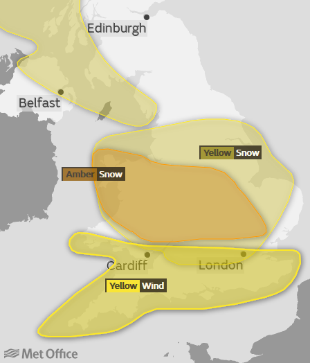
Following in the footsteps of Storm Caroline a couple of days ago, another storm is now putting some people’s lights out here in South West England. This one doesn’t have an official name, but nonetheless here is the United Kingdom Met Office’s recent forecast:

Whilst areas further north have an “amber” warning for snow, here is the Met Office’s official “yellow” wind warning for Southern England this morning:

UKMO-2017-12-10_0400

A spell of strong winds is expected to spread eastwards across the far south of the UK. Gusts of 50 mph are likely quite widely, with 60 mph gusts in places and close to 70 mph at times in the most exposed coastal locations. The highest gusts and strongest winds are expected Bristol Channel coastal areas during Sunday morning. High winds will also be accompanied by heavy showers, with a chance of hail and thunder, in parts of south Wales and southwest England.

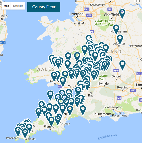
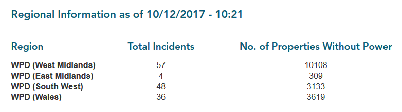
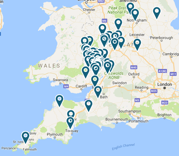
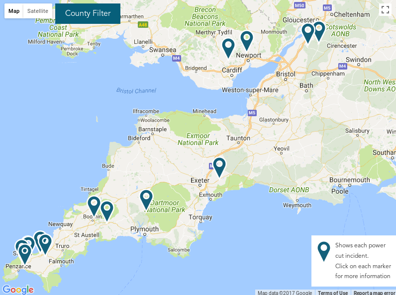
Those “strongest winds in Bristol Channel coastal areas” have certainly done some damage to Western Power Distribution’s electricity distribution grid this morning. It looks as though the snow and ice across the Midlands has had an effect too:

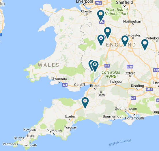
WPD-Map-2017-12-10_1028

WPD-Table-2017-12-10_1028

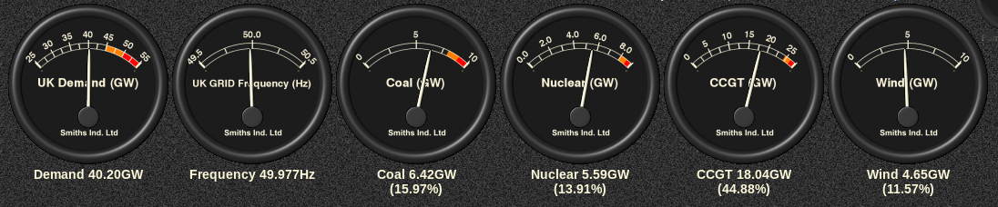
As has been our recent custom, here too is UK plc’s current electricity generation mix courtesy of Gridwatch:

GridWatch-Main-20171210-1030

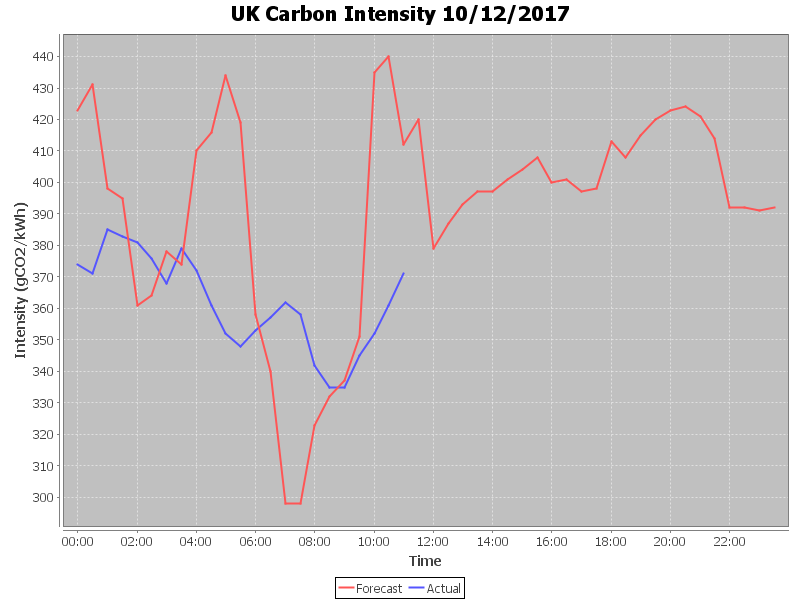
and here is a graph of UK plc’s carbon intensity so far today:

CarbonIntensity_20171210-115134


[Edit – December 11th 10:00]

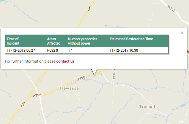
STOP PRESS! We had a brief power cut here at V2G Towers in Tremail this morning. It only lasted for a couple of minutes, and is presumably related to this problem just up the road in Davidstow:

WPD-Davidstow2017-12-11_1000


[Edit – December 11th 17:45]

Suppy has now been restored to the remaining 15 properties in the Davidstow area that have been without mains electricity for most of today.

WPD-Map-2017-12-11_1745

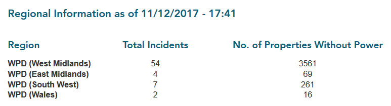
Whilst the number of properties without power across WPD’s network has been reducing today there are still a little under 4,000 remaining, largely in the West Midlands:

WPD-Table-2017-12-11_1745

Earlier today WPD issued a press release concerning the effects of Storm Caroline on their distribution network:

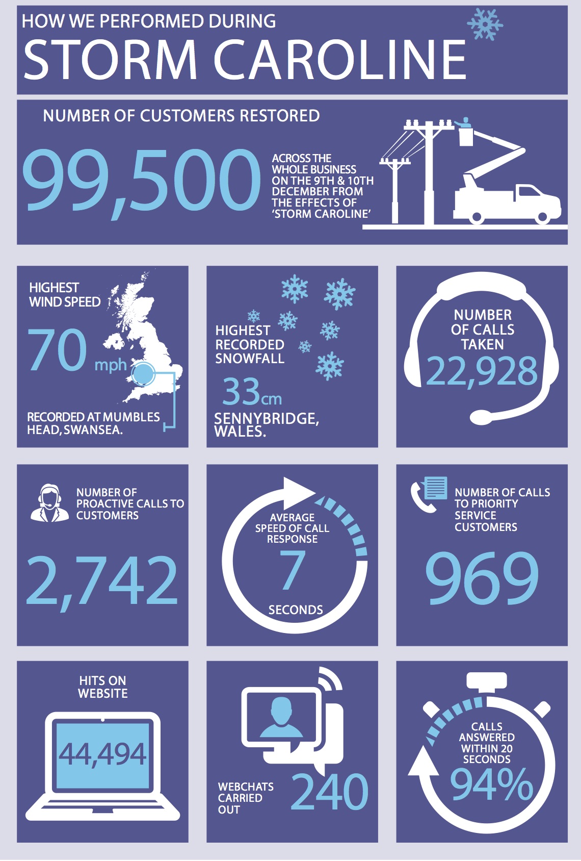
Over the weekend we restored just over 99,500 customers, 70,000 of those were in the West Midlands and 15,000 in South Wales which have been the two worst affected areas.

We do not anticipate any further disruption to be caused by the weather conditions based on the latest forecasts we have received.

Since first light this morning, additional resources from other areas have been drafted into the West Midlands to aid with outstanding restorations and repairs.

Over the course of Saturday and Sunday the Contact Centre handled over 20,000 calls with an average speed of response of 7 seconds. 94% of calls were answered in twenty seconds or under. Extra staff worked in both Centres with Ramp Up Rooms opened in our Bristol and Plymouth offices in addition to homeworkers being logged in as well. The transport team also assisted in getting staff into the Contact Centres who were struggling due to the adverse weather conditions.

The British Red Cross were activated twice but were also offered to multiple customers in addition to this who turned down the offer of the support. 969 proactive calls were also made to registered vulnerable customers offering support and advising them when their power supply would be restored.

Below is a snapshot of our performance and associated information covering Saturday 9th and Sunday 10th December.

WPD-Storm-Caroline


[Edit – December 11th 23:55]

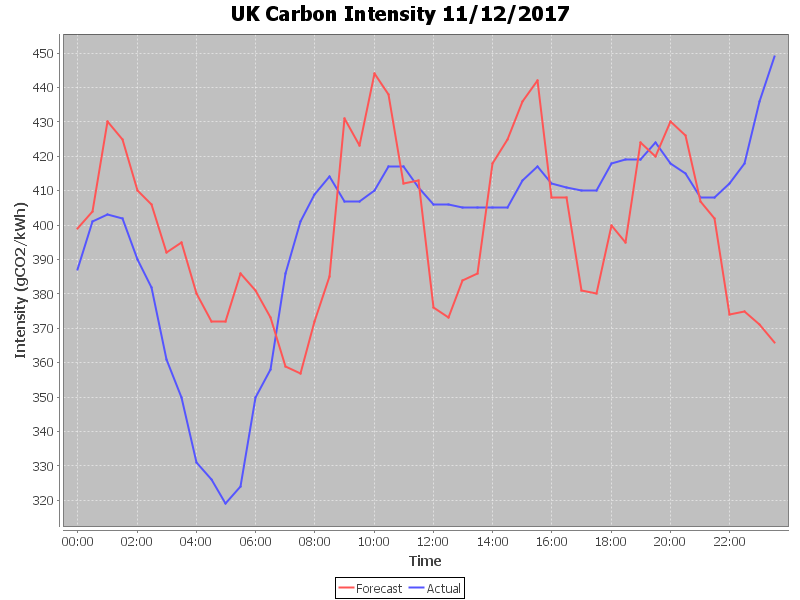
An intriguing carbon intensity graph for the coldest night of the winter so far:

CarbonIntensity_20171211

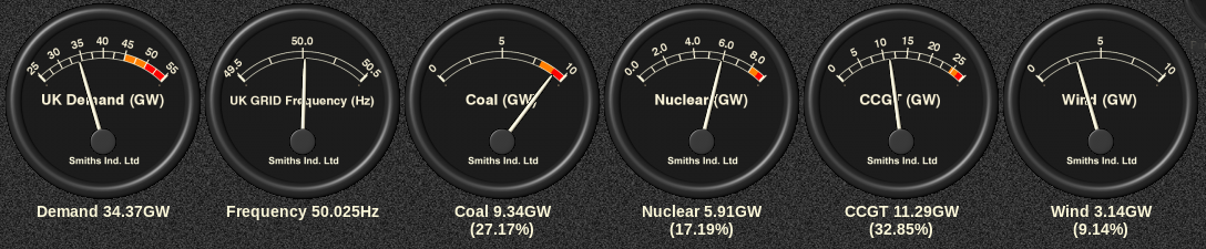
Coal fired generation is working quite hard at the moment!

GridWatch-Main-20171211-2355


[Edit – December 12th 11:00]

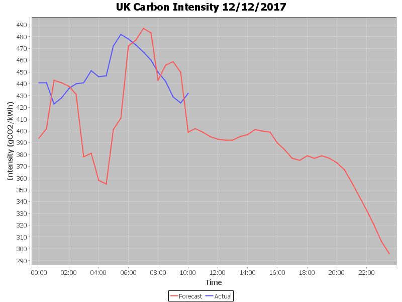
UK plc’s carbon intensity reached a peak of over 480 gCO₂/kWh overnight:

CarbonIntensity_20171212-105540

Meanwhile WPD’s power cut map has finally reverted to something approaching normality:

WPD-Map-2017-12-12_0706

Hurricane Ophelia Power Cuts

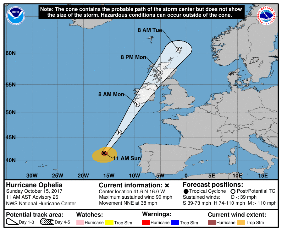
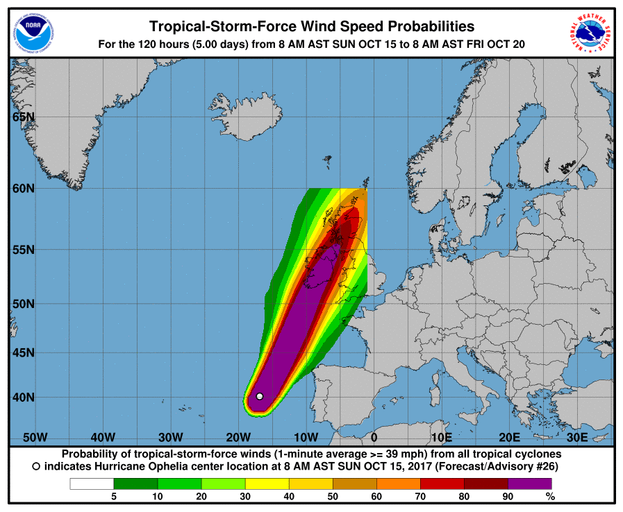
Hurricane Ophelia is heading in our direction. Reaching category 3 strength earlier today she is the strongest hurricane on record this far east in the North Atlantic. Moving further north over cooler waters her maximum wind speeds have now reduced to category 2. By the time she gets here she will have morphed into an extratropical cyclone, but she’ll still be packing hurricane force winds. Here is the current forecast from the United States’ National Hurricane Center:

ophelia_5day_cone_20171015-15Z

ophelia_wind-prob_20171015-15Z

Met Éireann have issued a red wind warning across the south of Ireland:

Wind Warning for Wexford, Galway, Mayo, Clare, Cork, Kerry, Limerick and Waterford

Hurricane Ophelia is expected to transition to a post tropical storm as it approaches our shores on Monday bringing severe winds and stormy conditions . Mean wind speeds in excess of 80 km/h and gusts in excess of 130km/h are expected, potentially causing structural damage and disruption, with dangerous marine conditions due to high seas and potential flooding.

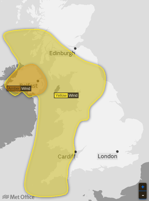
Here’s the Met Office’s warning of an amber alert for Northern Ireland tomorrow, together with a yellow wind warning for us here in Cornwall:

ophelia-UKMO-warning_20171015+1d

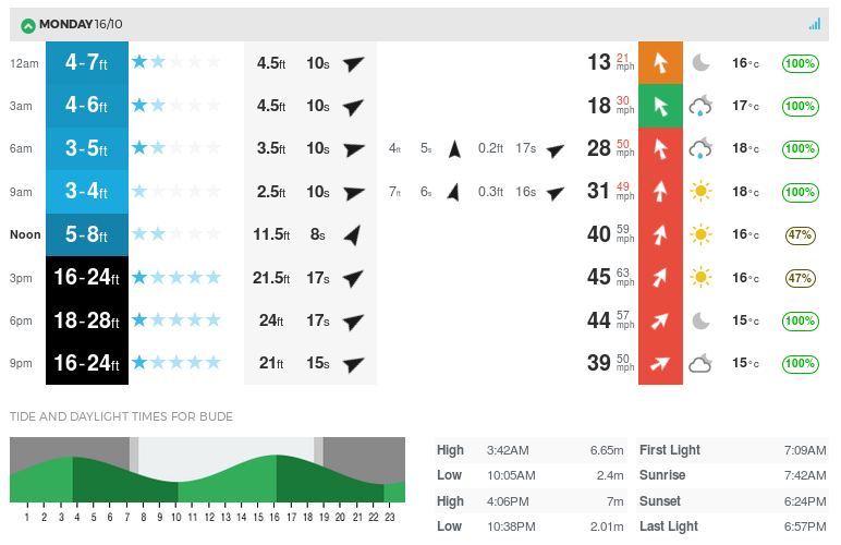
Finally, for the moment at least, here is the current Magic Seaweed surf forecast for North Cornwall tomorrow:

WidemouthSurf-20171015+1d


[Edit – October 16th 08:00]

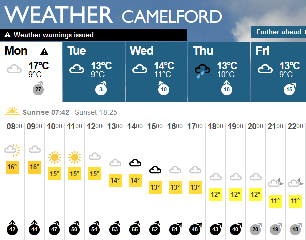
Here’s our weather forecast for today in North Cornwall:

BBC-Camelford-2017-10-16_0800

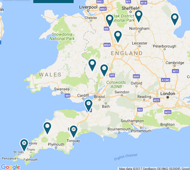
It definitely sounds blustery outside! Western Power Distribution’s power cut map doesn’t display anything too unusual yet:

WPD-Map-2017-10-16_0721

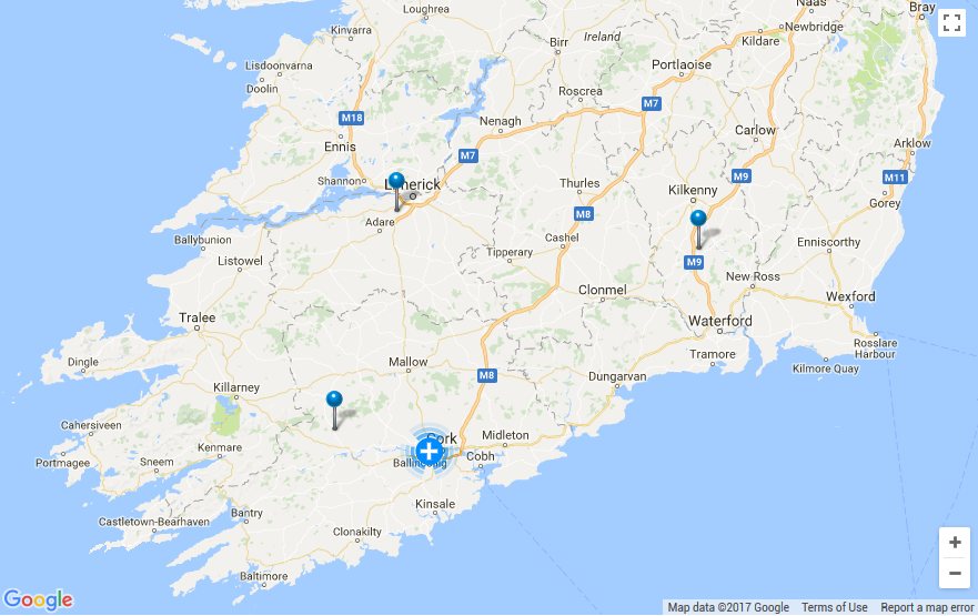
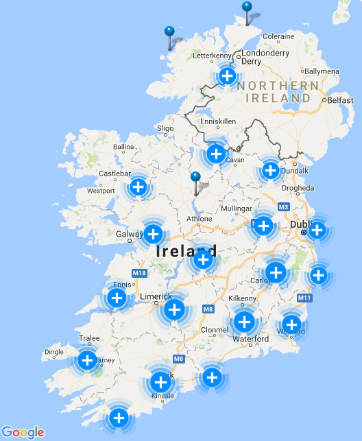
However a few power cuts have started appearing on ESB Networks’ map of Southern Ireland:

ESB-Map-2017-10-16_0824


[Edit – October 16th 11:00]

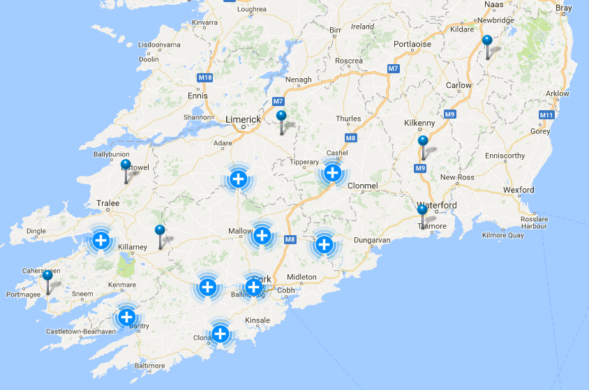
Over 35,000 properties are now without power across southern Ireland:

ESB-Map-20171016-1058

The lights are starting to go out here in South West England too:

WPD-Map-20171016-1053

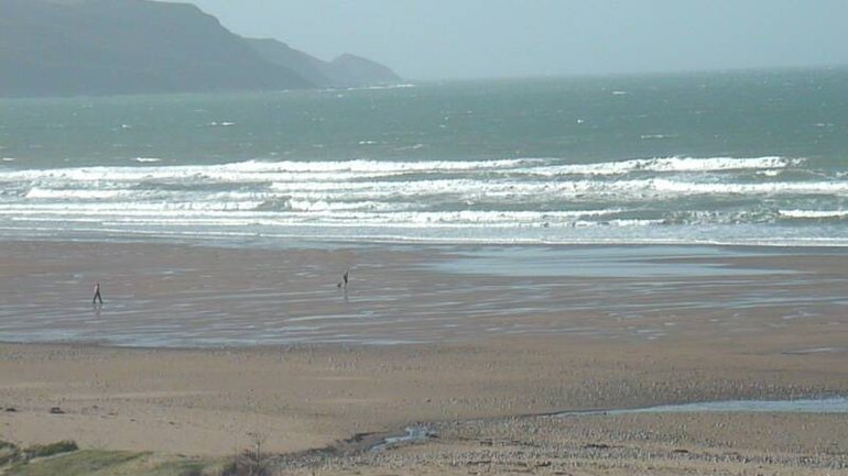
The waves are getting bigger too:

Widdy-20171016-1107


[Edit – October 16th 16:00]

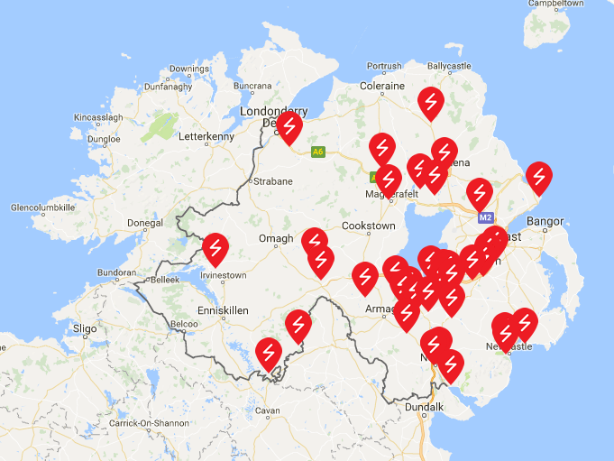
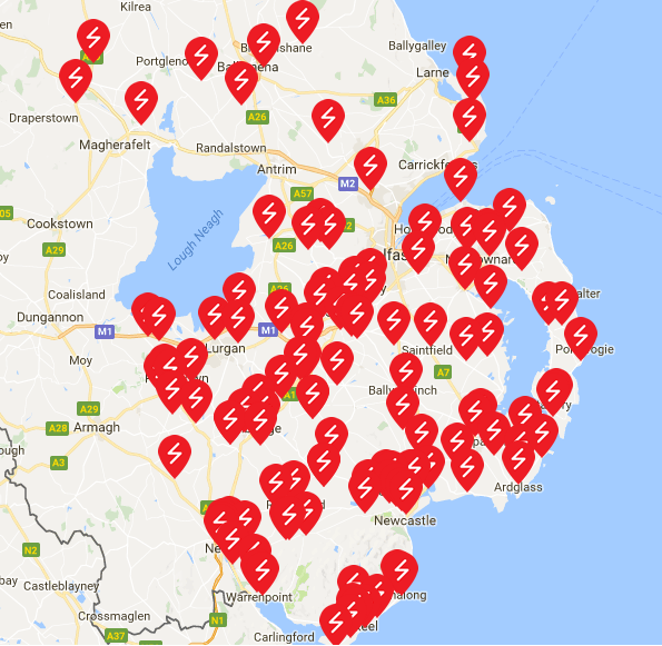
The ESB Networks power cut map seems to have given up under the strain. At 14:00 it showed over 180,000 properties without power. Meanwhile the storm has been bringing down power lines in Northern Ireland:

NIE-Map-2017-10-16_1613

and Wales:

WPD-Map-2017-10-16_1613

There are now a total of ~3500 properties without power across Western Power Distribution’s four areas of the country. Here’s how our local surf spot looks at the moment:

Widdy-20171016-1504


[Edit – October 17th 11:00]

Here’s a selection of reports about Ophelia from the media, together with this morning’s set of power cut maps:

ESB-Map-20171017-1012

NIE-Map-20171017-1012

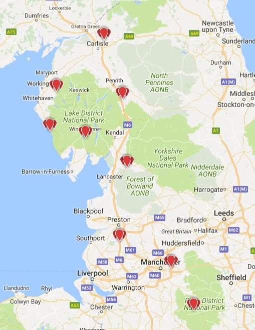
Engineers from Electricity North West are working in difficult conditions today to restore power after ex-hurricane Ophelia hit the North West overnight.

The region’s power network operator has restored supplies to more than 16,000 properties throughout the night following the Met Office’s yellow weather warning for severe gales of 60 to 65mph.

Around 2,000 properties remain without power as flying debris has hit power lines and high winds make access difficult for repair teams. Properties are affected mainly in the Lake District with 1,700 without power and 150 properties in Lancashire are currently without power.

ENW-Map-20171017-1025

As a result of the high winds brought by the remnants of Storm Ophelia, whilst a number of customers have had their electricity supplies affected, the level of power cuts is considered busy but not exceptionally so.

The biggest impact has been in West Wales and Cornwall where a number of weather related incidents have occurred.

Currently around 3,000 customers are off supply. All incidents are currently being worked on by our engineers, with supplies on track to be restored this evening.

Since around 9am this morning we have restored around 12,000 customers in the South West and South Wales.

WPD-Map-20171017-1025

According to ESB Networks:

We are advising all customers impacted by outages that they should prepare to be without electricity for number of days. It is very important that any customers who use electrically powered medical devices should contact their healthcare professional to make alternative arrangements if necessary.

According to the Irish Times:

The country is facing days of “catch-up” as schools, hospitals, roads, electricity networks and other key public infrastructure are cleared of debris or repaired following Storm Ophelia.

Three people were killed on Monday in the worst storm to hit Ireland in more than 50 years, which left hundreds of thousands without electricity overnight.

The storm caused the most devastation in the south and west but left every county with some level of disruption.

Ministers and senior officials have warned that it will take days for some public services to get back to full strength. All schools will remain closed on Tuesday to allow for safety inspections to take place, with most expected to reopen on Wednesday.


[Edit – October 18th]

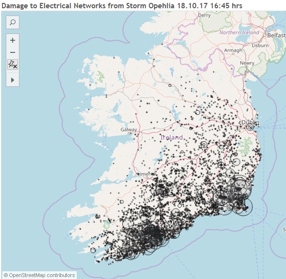
ESB Networks report that:

The following map shows the remaining faults caused by ex-hurricane Ophelia to be repaired. We have restored over 70% of homes and businesses and here are currently 105,000 homes and businesses still without power that are represented on the following map by the black circles. The bigger the circles the more faults there are that need to be repaired in that area.

ophelia-heat-map-20171018

Electricity North West have now repaired almost all the faults caused by Ophelia:

Engineers from Electricity North West have worked tirelessly to repair damage caused by ex-hurricane Ophelia and subsequent bad weather and restore power to the majority of customers in the region.

Despite working round the clock to restore power to those affected by ex-hurricane Ophelia on Monday and early Tuesday, further bad weather last night from 6.30pm caused power cuts to another 5,000 properties along the county’s west coast.

Engineers worked through the night and restored power to all but 18 customers and they will continue to work today to restore those final few customers located in Egremont, Cumbria.

Electricity North West has turned their attention to assisting the restoration efforts in the Republic of Ireland. A team of more than 30, including engineers and overhead lines people, will help repair damage and restore power to thousands still without power in the Republic of Ireland.


[Edit – October 19th]

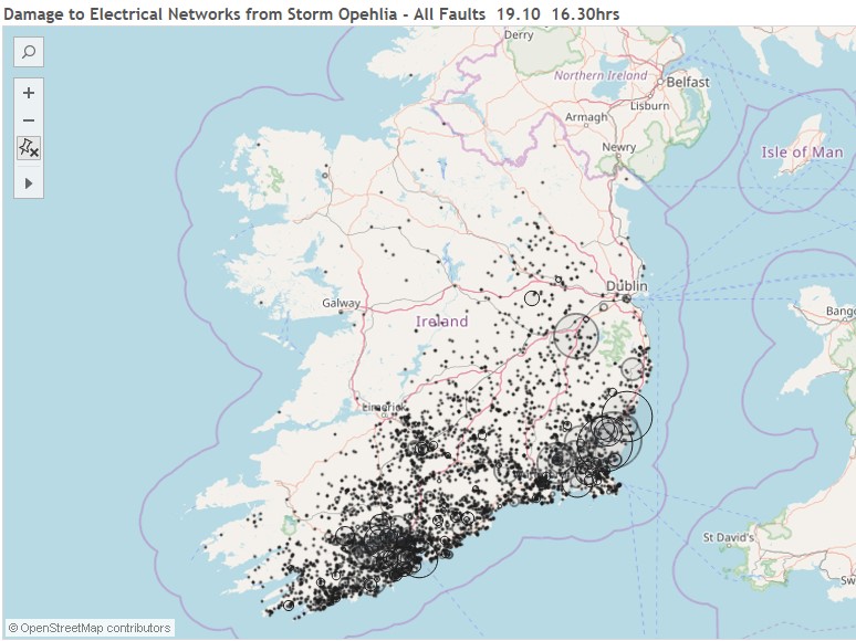
ESB Networks have produced another power cut heat map. This evening they say that:

ESB Networks have now restored power to 322,000 homes, farms and businesses affected by ex-hurricane Ophelia. The following map illustrates the ​63,000 homes and businesses that we are currently working to restore.

ophelia-heat-map-20171019


[Edit – October 20th]

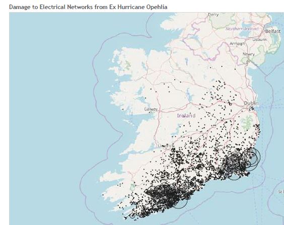
Here’s the latest power cut heat map from ESB Networks:

42,000 homes, farms and businesses remain without power this morning. These are highlighted in the following heat map.

ophelia-heat-map-20171020

The rate of progress numbers wise from here will slow down as each individual fault must be repaired pole by pole. Also with the weather forecast to worsen the conditions that the crews are working in makes the restoration effort more difficult and slower.

In a later news release they report that:

ESB Networks have now continued to restore power this morning, with power now restored to 343,000 families, farms and businesses. Approximately 42,000 customers remain without supply.

​The worst impacted areas are in the environs of Enniscorthy, Wexford town, New Ross, Bandon, Dunmanway and Fermoy.

Assisted by contractors, crews from Northern Ireland and overseas utilities, as well as the army and air corps, ESB Networks will continue restorations to every last family, farm and business until their lives are back to normal.

A Met Éireann Status Orange wind warning has been issued for seven coastal counties, including Cork and Wexford, will hamper restoration efforts. Should the weather conditions worsen further, our crews will be stood down until it is safe to resume repairs again. Winds speeds up to 130 km/h will cause outages to customers in Mayo, Galway, Clare, Kerry, Cork, Waterford and Wexford on Saturday.

Hurricane Irma Power Outages

The power outages in Texas caused by the recent passage of Hurricane Harvey haven’t all been repaired yet. Now a whole lot more people next door in Florida are finding themselves without electricity thanks to the arrival of Hurricane Irma. According to the latest update on Irma from the United States’ National Hurricane Center:

The center of Hurricane Irma made landfall at Cudjoe Key in the
lower Florida Keys at 9:10 am EDT. A gust to 106 mph (171 km/h)
was just reported at the National Key Deer Refuge in Big Pine Key.

SUMMARY OF 910 AM EDT…1310 UTC…INFORMATION
———————————————-
LOCATION…24.7N 81.5W
ABOUT 20 MI…30 KM ENE OF KEY WEST FLORIDA
MAXIMUM SUSTAINED WINDS…130 MPH…215 KM/H
PRESENT MOVEMENT…NNW OR 330 DEGREES AT 8 MPH…13 KM/H
MINIMUM CENTRAL PRESSURE…929 MB…27.43 INCHES

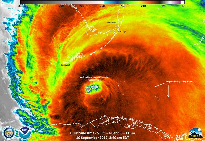
Here’s how Irma looked from the Suomi satellite whilst crossing the Straits of Florida:

and here’s a NOAA video showing Irma making landfall at Cudjoe Key:

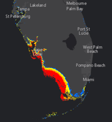
This is the National Hurricane Center’s storm surge forecast for the next three days:

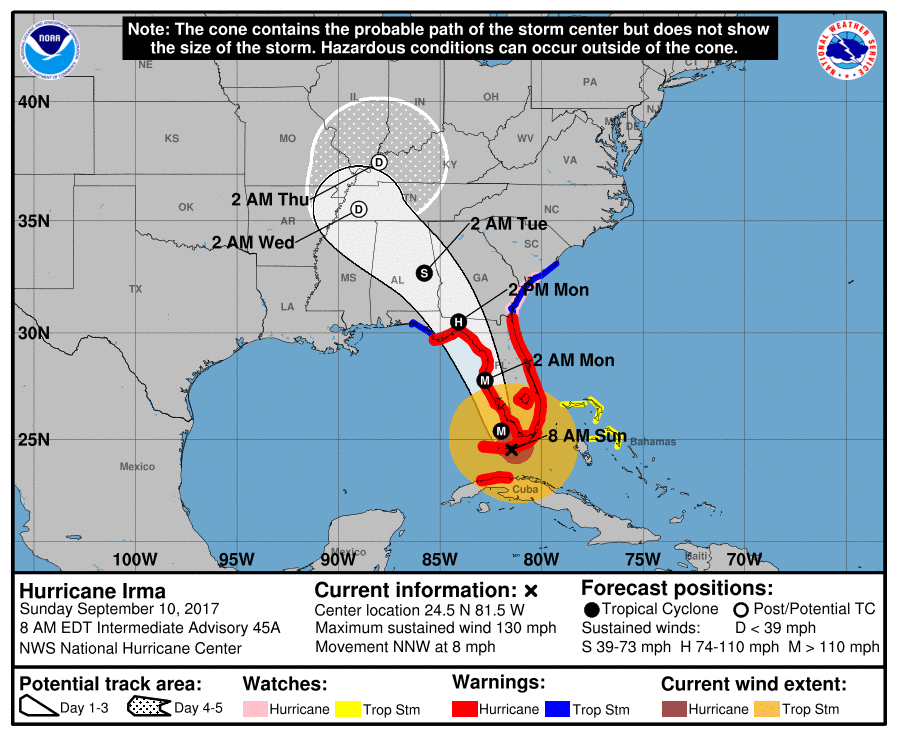
The red area represents a greater than 10% chance of a surge of nine feet and over. Finally, for the moment at least, here’s Irma’s current forecast track from slightly earlier in the day:

Already over 750,000 premises across Florida are without electric power.


[Edit – September 11th]

Here’s a video from ABC about the effects of Hurricane Irma on Florida’s electricity distribution infrastructure:

Another video in which Rob Gould of Florida Power and Light says:

What we will see on the west coast is a wholesale rebuild of our electric grid.

At 9 AM this morning British Summer time the lights have started going out in Georgia, and over 4.5 million premises across Florida are without electric power.


[Edit – September 11th PM]

Florida Governor Rick Scott reports on the impact of what is now Tropical Storm Irma:

There are now over 6.5 million premises across Florida, Georgia and the Carolinas without electric power.

Hurricane Harvey Power Outages

Major Hurricane Harvey reached category 4 before landfall on the coast of Texas last night. Apart from numerous other forms of damage a large number of properties will lose their supply of electric power over the next few hours and days. In advance of Harvey’s arrival The Electric Reliability Council of Texas (ERCOT for short) issued a press release, which read as follows:

AUSTIN, TX, Aug. 25, 2017 – The Electric Reliability Council of Texas (ERCOT) has issued a weather-related watch in preparation for Hurricane Harvey, which is expected to make landfall late Friday night or early Saturday morning.

ERCOT anticipates the hurricane may cause damage to infrastructure from high-speed wind, along with significant flooding in the South, South Central and Coastal weather zones in the ERCOT region. This includes the cities of Houston, Corpus Christi, Brownsville, Austin and San Antonio. These conditions may cause a number of power outages throughout the ERCOT region.

The ERCOT System Operations team is working 24/7 at ERCOT’s System Control Center, which is built to withstand hurricane-force winds, to monitor the situation and protect overall system reliability. Extra engineering staff will be supporting their efforts throughout the weekend.

ERCOT also has been communicating with transmission and generation owners regarding hurricane preparations. Generation owners are implementing their own hurricane procedures to ensure the safety of their staff and equipment.

ERCOT remains focused on maintaining system reliability throughout the entire ERCOT region. At this time, ERCOT anticipates it will have sufficient generation available during the hurricane, while storm-related damage is expected to result in widespread power outages.

Please visit www.ercot.com/help/harvey for updates throughout the weekend. This site includes Frequently Asked Questions as well as helpful contact information.

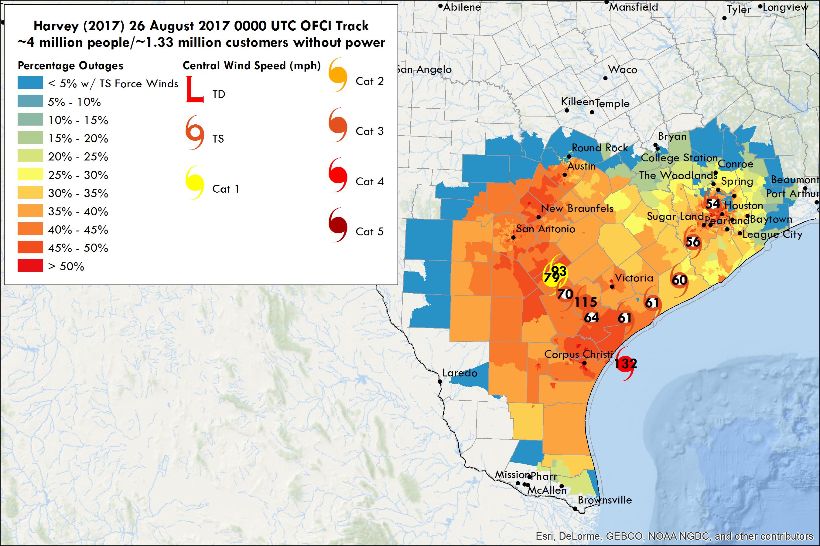
Researchers from Michigan, Ohio State and Texas A & M Universities have created a model to predict power outages (as they’re referred to in the United States) resulting from Harvey’s passage. Here’s their current forecast:

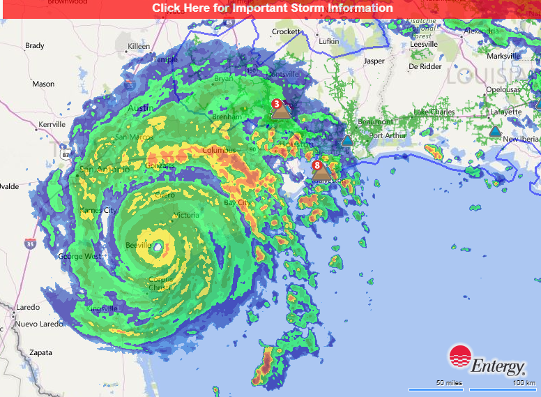
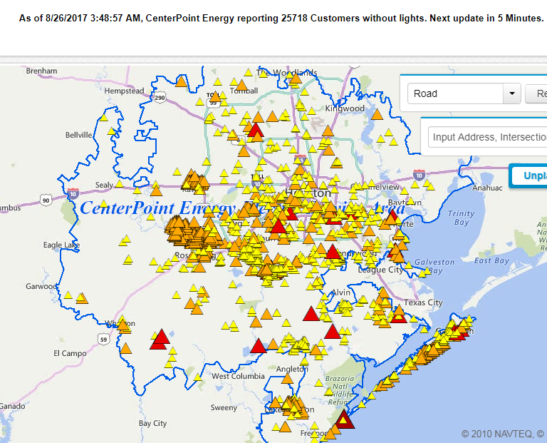
Currently over 200,000 properties in Texas are without electric power as a result of Harvey. That number will increase! Here’s some example outage maps at the moment (09:00 UTC):


[Edit – August 26th 12:00]


[Edit – August 26th 15:00]

ERCOT report via Twitter that:


[Edit – August 27th 12:00]

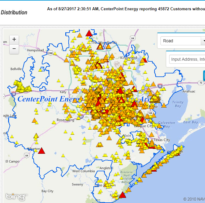
Power outages across Texas dropped below a quarter of a million overnight, but have now risen again to over 260,000. There has been a large increase in the region powered by CenterPoint Energy:

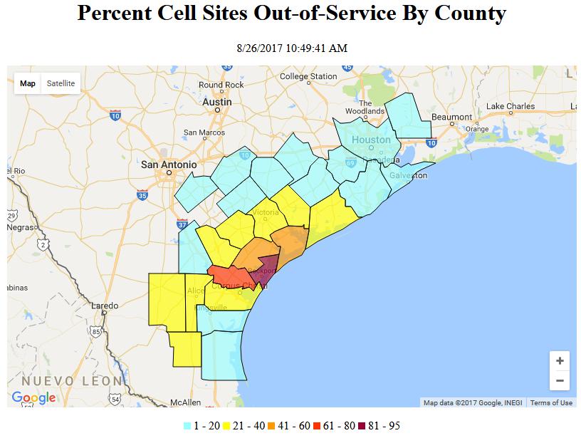
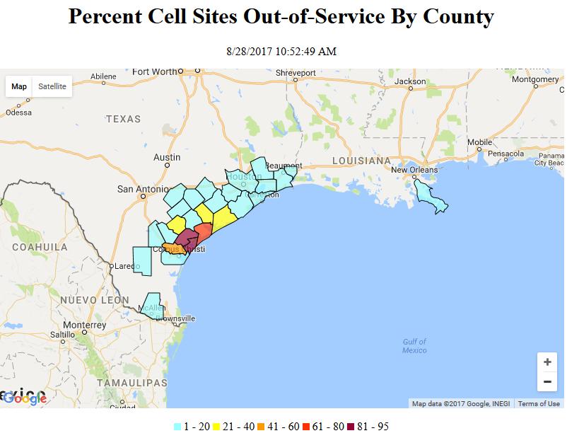
A problem that we’re all too familiar with here in South West England is that power outages can lead to communications outages. The United states’ Federal Communications Commission has issued a report on the effects of Hurricane Harvey on the cellphone infrastructure in Texas:

The following is a report on the status of communications services in geographic areas impacted by Hurricane Harvey as of August 26, 2017 at 10:30 a.m. EDT. This report incorporates network outage data submitted by communications providers to the Federal Communications Commission’s Disaster Information Reporting System (DIRS). DIRS currently covers areas of Texas and Louisiana. Note that the operational status of communications services during a disaster may evolve rapidly, and this report represents a snapshot in time.

While we don’t have reports for all counties yet, there are at least 149,909 subscribers out of service in the affected area. This includes users who get service from cable system or wireline providers. There are 5 switching centers out of service and 38 switching centers on back-up power.

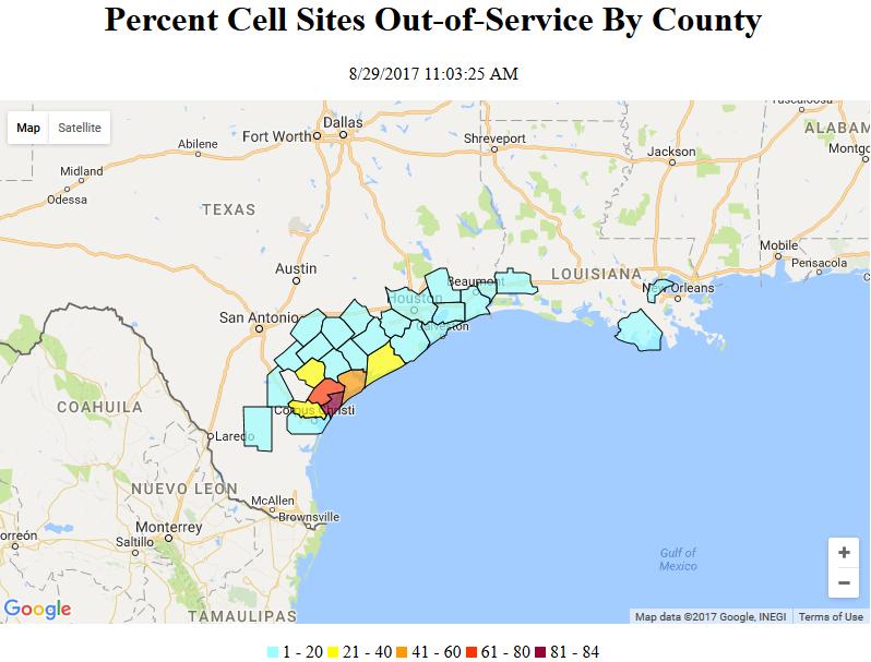
There are 4% of the cell sites down in the affected area. The counties with greater than 50% of cell sites out are Aransas, Refugio, and San Patricio in TX. There are no cell sites affected in LA.

The FCC also reports that:

The Public Safety and Homeland Security Bureau (PSHSB) learns the status of each Public Safety Answering Point (PSAP) through the filings of 911 Service Providers in the Disaster Information Reporting System (DIRS), through reporting done to the FCC’s Public Safety Support Center (PSSC), coordination with state 911 Administrators and, if necessary, individual PSAPs. There are a total of 9 PSAPs affected:

Portland Police Department, TX is down with no re-routes.
Calhoun County Sheriff, TX is up without Automatic Location Information (ALI).
Port Aransas Police Department, TX; Cameron Parish Sheriff’s Office, LA; Victoria Police Department, TX; Mathis Police Department, TX; Refugio County Sheriff’s Office, TX; Ingleside Police, TX; and Robstown Police Department, TX have either been re-routed to administrative lines or re-routed to another PSAP.
Cameron Parish Sheriff’s Office and Victoria Police Department have been re-routed with ALI, all other re-routes are without ALI.

There are 5 radio stations out of service: TX – WKNC, KKTX, KUNO, KKWV, and KAYK
There are no TV stations reported as being out of service.


[Edit – August 27th 22:30]

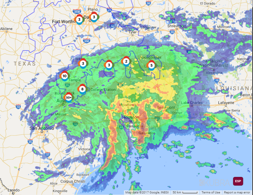
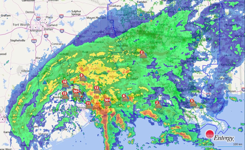
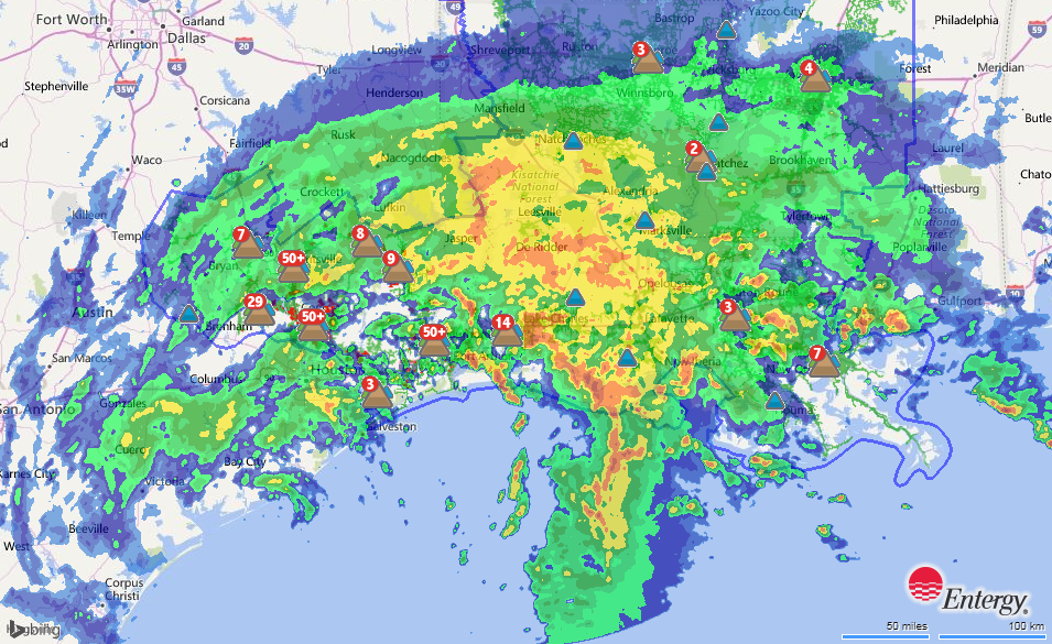
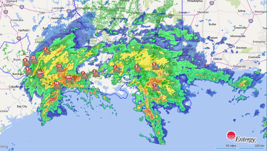
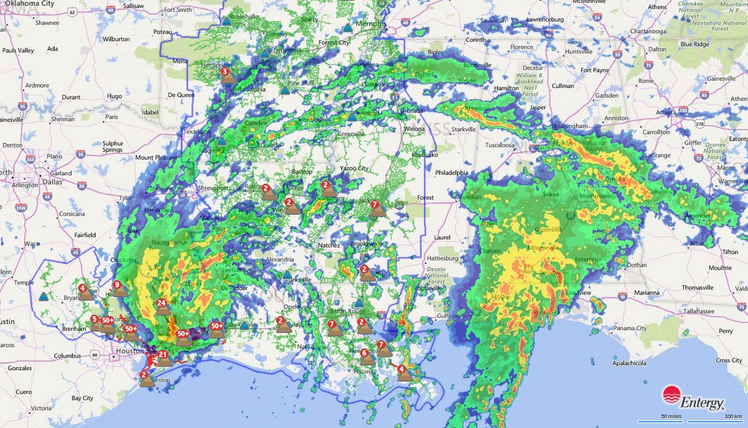
There are currently still over 300,000 power outages across Texas. This rainfall radar map shows that the Houston area is still enduring very high rates of precipitation:


[Edit – August 28th 09:30]

The number of reported outages has dropped overnight (UTC), but there are still over 250,000 “customers” without electric power in Texas, plus some more in Louisiana. Here’s the current Entergy Texas outage map as Harvey heads back towards the Gulf of Mexico:

The FCC reported yesterday that:

There are a total of 17 (up from 9 yesterday) PSAPs affected:

PSAP down with no re-route: Portland Police Department, TX.
PSAP up without Automatic Location Identification (ALI): Calhoun County Sheriff, TX.
PSAP re-routed without ALI: Aransas County SO, TX; Bee PD, TX; Beeville PD, TX; Kingsville PD, TX; Kleberg County SO, TX; Mathis PD, TX; Port Aransas PD, TX; Refugio County SO, TX; and Ingleside PD, TX.
PSAP re-routed with ALI: Aransas Pass PD, TX; Cameron Parish SO, LA; Richmond PD, TX; Robstown PD, TX; Victoria PD, TX; and Wilson County SO, TX.

There are 4.1% of the cell sites down in the affected area. The counties with greater than 50% of cell sites out are Aransas, Calhoun, Refugio, and San Patricio in TX. There are no cell sites affected in LA.


[Edit – August 28th 15:00]

Reported outages are heading for 300,000 again whilst Texas wakes up to further flooding as Harvey heads back to the coast:


[Edit – August 29th 09:00]

Reported outages have dropped somewhat overnight, as the centre of Tropical Storm Harvey is now over the Gulf of Mexico once again:

Yesterday evening local time ERCOT issued the following statement:

The ERCOT grid continues to be in stable condition following Hurricane Harvey. However, several transmission lines remain out of service, especially near Corpus Christi and Victoria where Hurricane Harvey made landfall.

Two major 345-kV transmission lines serving the Gulf Coast area are still out of service, along with many other high-voltage transmission lines. As of mid-day today, a little more than 6,700 MW of generation capacity, including a very small percentage of renewables, was off-line for reasons related to the storm.

Electricity demand in the days since landfall has been about 20,000 megawatts (MW) below typical August electricity use, peaking at less than 44,000 MW, due to a combination of structural damage along the coast and cooler temperatures in much of the region.

The FCC reported yesterday that:

There are 4.7% of the cell sites down in the affected area, up from 4.1% yesterday. The counties with greater than 50% of cell sites out are Aransas, Calhoun, and Refugio in TX. Plaquemines is the only county in LA reporting any cell sites out.


[Edit – August 29th 12:00]

As a new day dawns in Texas reported outages are increasing once again. Over 270,000 in Texas plus ~5,000 so far in Lousiana:


[Edit – August 30th 10:00]

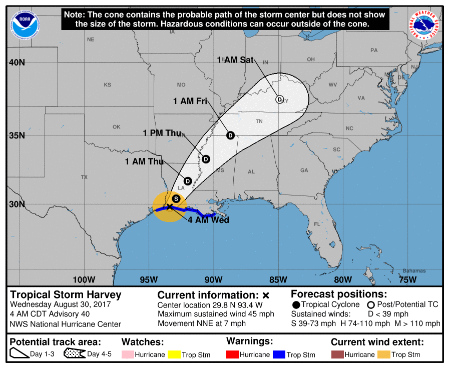
The latest forecast from the United States’ National Hurricane Center shows that at long last Harvey will move inland and dissipate:

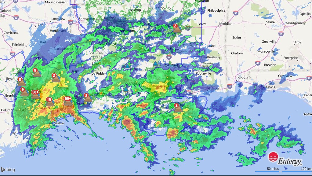
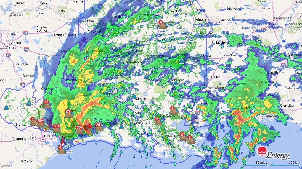
Rainfall radar reveals that the rain has stopped falling over Houston:

The power outages continue however. There’s still over a quarter of a million properties without power in Texas, with a few thousand more in both Louisiana and Mississippi. Whilst we wait to see when the number of outages starts to reduce significantly, here’s a rainfall radar animation of Harvey’s progress so far:

The FCC reported yesterday that:

There are 4.7% of the cell sites down in the affected area, the same as yesterday. The counties with greater than 50% of cell sites out are Aransas and Refugio in Texas. In Louisiana, Calcasieu, St. John the Baptist, and Terrebonne are the only parishes to report any cell site outages, with each having only one cell site out.


[Edit – August 30th 15:00]

Power outages due to ex Hurricane Harvey are back up over 300,000:

Watch this space!

Storm Doris Blacks Out Britain

Here is the United Kingdom Met Office’s severe weather warning map for today:
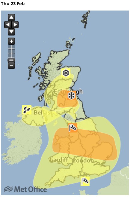
According to the Met Office forecast for the West Midlands:

Some very strong winds are expected on Thursday in association with storm Doris with gusts of 60-70 mph likely, and 70-80 mph on coasts and hills.

There is still some uncertainty about the track of storm Doris, but increasing confidence that there will be widespread disruption across parts of England and Wales.

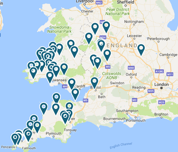
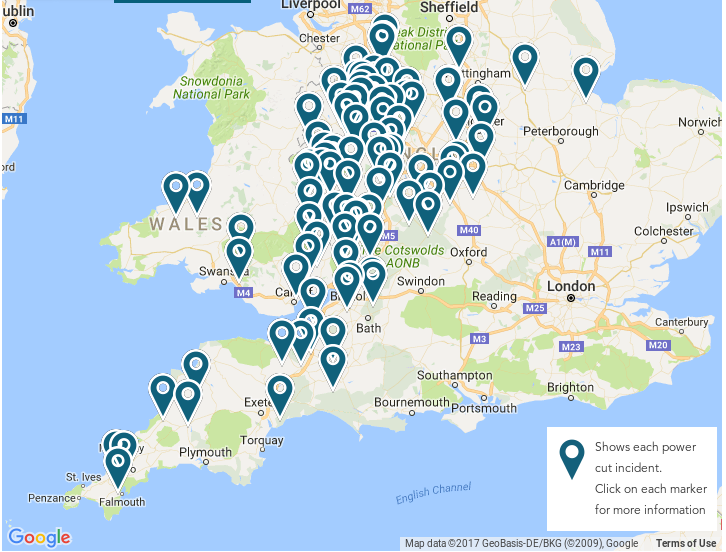
Earlier this morning we took a snapshot of Western Power Distribution’s live power cut map. It looked like this:

It’s now 10 AM on Thursday February 23rd, and WPD’s map now looks like this:
 

[Edit – Feb 23rd 12:15]

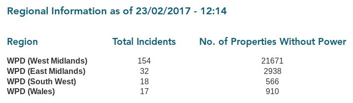
It’s now 12:15 PM on Thursday February 23rd. Over 20,000 properties are now without electric power in Western Power Distribution’s West Midlands region alone:

Electricity Northwest are tweeting helpful information to their online customers:

So are UK Power Networks:

However if you’ve just had a power cut you’d need to have a UPS for your PC in order to read those helpful messages! Or a fully charged mobile device with nearby comms towers still powered up!


[Edit – Feb 23rd 13:15]

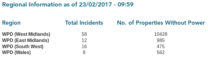
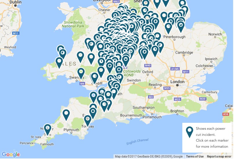
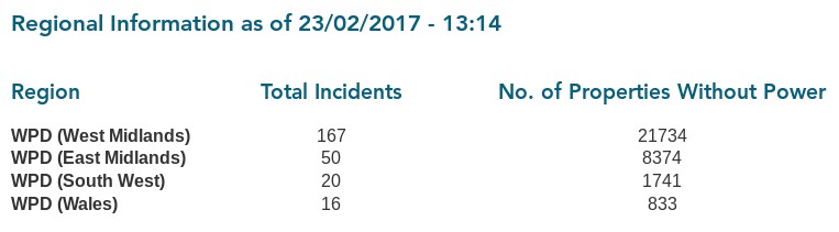
It’s now 13:15 on Thursday February 23rd. Over 30,000 properties are now without electric power across Western Power Distribution’s East and West Midlands regions:
Scottish & Southern Energy Networks have issued a news release:

SSEN engineers are making good progress in reconnecting customers affected by damage to overhead lines and network equipment. Since midnight, SSEN engineers have successfully restored power to over 22,000 homes, with approximately 5,000 homes currently without power. All faults are fully resourced and all customers are expected to be restored tonight.

The worst of the conditions have been observed in Oxfordshire, Berkshire and Hampshire where a wind gust of 65mph was recorded in Odiham.

SSEN has more than 1,000 engineering, technical and support staff on duty. Ahead of the storm, engineering teams were mobilised to key locations to minimise disruption and inconvenience to customers.

Customer service teams have been contacting over 7,000 customers on our Priority Service Register to check on their wellbeing in case they need additional help.


[Edit – Feb 23rd 14:45]

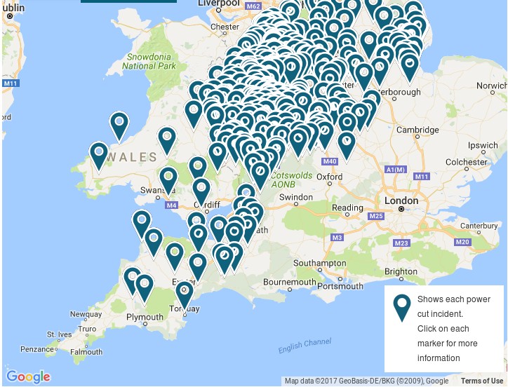
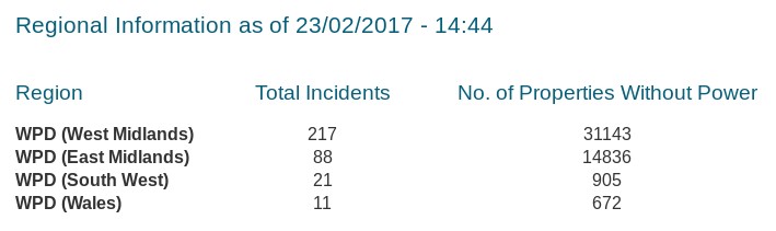
It’s now 14:45 on Thursday February 23rd. Over 45,000 properties are now without electric power across Western Power Distribution’s East and West Midlands regions:
 

[Edit – Feb 23rd 16:00]

It’s now 16:00 on Thursday February 23rd. WPD’s live power cut map is down for maintenance:
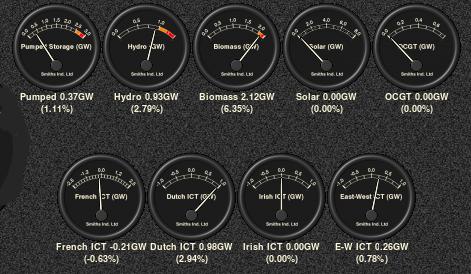
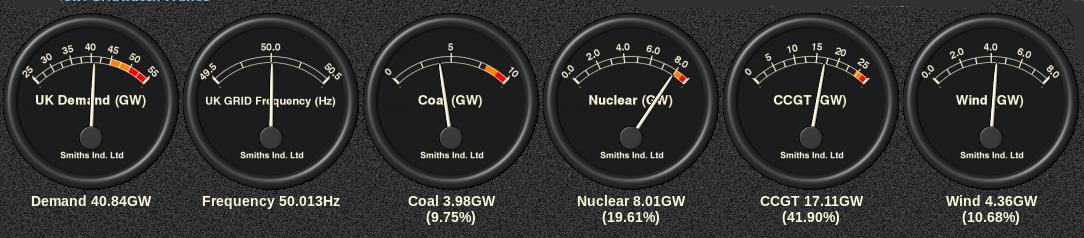
It’s obviously fairly breezy across the United Kingdom today! Let’s take a look at the current UK electricity generation mix at the moment, courtesy of GridWatch:
Western Power Distribution have issued a severe weather update:

We are currently exceptionally busy within WPD with the East and West Midlands area being especially affected in particular by the effects of Storm Doris so far.

Issued on: Thursday 23rd February – 3pm

The West Midlands has been significantly affected with almost 22,000 customers currently off supply with the vast majority being affected between 09:00 and 12:00 with Hereford, Ludlow, Worcester, Telford and Stoke suffering the worst effects.

During the last hour the fault rate in East Midlands has picked up where we have around 10,000 without power as the storm is now tracking eastwards as expected.

Our engineers are currently working hard to restore supplies as quickly and safely as possible, and we have additional staff in our Contact Centres, Control Rooms and operational depots.

The South West and South Wales areas were impacted earlier today, but not exceptionally so. Both areas have fewer than 3,000 customers affected and all incidents are currently resourced and being worked on.

Electricity North West have issued a press release, which begins:

Engineers from Electricity North West are working in difficult conditions today to restore power as Storm Doris hits the North West.

The region’s power network operator has restored supplies to around 5,000 properties throughout the morning following the Met Office’s amber weather warning for severe gales of 70 to 80mph and a yellow warning for snow to hit the North West today.

Around 2,500 properties remain without power as flying debris has hit lines and high winds make access difficult for repair teams. Properties are affected mainly in Lancashire, Manchester and the Peak district including250 properties currently without power in Horwich, Bolton.


[Edit – Feb 23rd 17:00]

It’s now 17:00 on Thursday February 23rd. WPD’s live power cut map is still down. However SSEN have issued a 4 PM update:

SSEN engineers are making good progress in reconnecting customers affected by damage to overhead lines and network equipment. Since midnight, power has been restored to over 29,000 homes, with approximately 8,000 homes currently without power. All faults are fully-resourced and we are working to restore power to all customers tonight.

The worst of the conditions have been observed in Oxfordshire, where around 5,000 customers are currently without power, as well as parts of Berkshire and Hampshire.


[Edit – Feb 23rd 18:30]

It’s now 18:30 on Thursday February 23rd. WPD’s live power cut map is still down! SP Energy Networks have now issued a press release:

The MET Office Amber warnings remain in place until 8pm tonight as Storm Doris continues to cause significant impact across the UK.

SP Energy Networks distribution licence area in Cheshire, Merseyside and North Wales has experienced extreme weather conditions today, with wind gusts of over 90mph experienced in exposed areas. Over the course of today we have restored power to over 50,000 customers impacted by this severe weather.

Our restoration efforts have been hampered today by the gale force winds making it unsafe for our engineering teams to work at height. The winds have now reduced somewhat, albeit we are still seeing wind gusts in excess of 50mph in exposed areas.
However, where it is safe to do so, our restoration efforts will continue this evening and tonight. As a result of the extensive damage experienced today, we now expect that some customers will be without power overnight.

Where possible, we will endeavour to make contact with those customers impacted to discuss welfare options. We have been working with the Red Cross who will help support our vulnerable customers impacted by today’s events.

Electricity North West have issued another press release:

Engineers from Electricity North West will work into the evening and through the night to restore the final properties affected by Storm Doris.

The region’s power network operator has restored supplies to around 6,700 properties throughout the day following the winds of 70 to 80mph in the North West.

800 properties remain without power in a number of small pockets, mainly across Lancashire as flying debris and fallen trees have hit power lines in the region.

Western Power Distribution have issued another severe weather update:

The current situation within WPD is still exceptionally busy, with the East Midlands, and even more so the West Midlands areas still having large numbers of customers off supply due to the effects of Storm Doris that passed through our area today.

Issued on: Thursday 23rd February – 6pm

There are approximately 20,000 customers in the West Midlands off supply and we have restored around a further 20,000 throughout the day. As of the last update the worst affected areas have been Hereford, Ludlow, Worcester, Telford and Stoke.

There are currently fewer than 10,000 customers off supply in the East Midlands with us having restored a further 10,000 approximately throughout the day.

Whilst busy, the volume of faults affecting the South West and South Wales have not been too bad, with all incidents being worked on and resourced. There are currently fewer than 1,500 customers off throughout the two areas and staff from those areas have been moved into the Midlands to assist where required.

Our contact centre has dealt with over 22,000 calls from customers with an average speed of response time of 6.7 seconds.

We have had one helicopter airborne today flying from Nottingham that has inspected two EHV faults in Stoke and Telford. Tomorrow, all four aircraft will be available from first light to aid and assist in repairs as required.


[Edit – Feb 23rd 20:00]

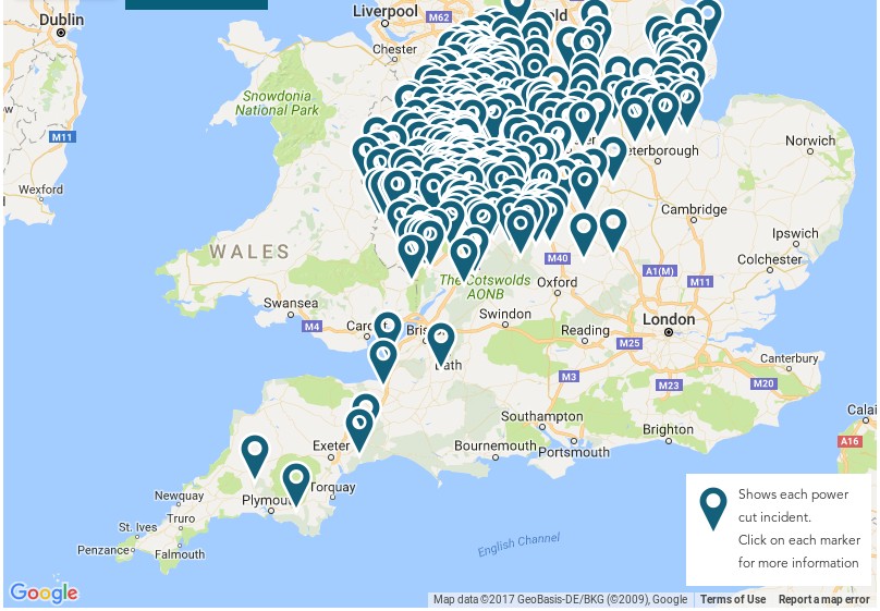
It’s now 20:00 on the evening of Thursday February 23rd. WPD’s live power cut map is operational again, and it’s moved to a dedicated subdomain! Here is what it reveals:
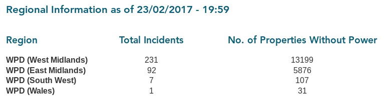
 

[Edit – Feb 23rd 22:30]

This will be our last update for today, at 22:30 on the evening of Thursday February 23rd. First of all WPD’s live power cut map, zoomed in on the Midlands:
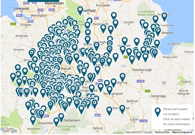
Next the 20:00 update from Scottish and Southern:
Since midnight, power has been restored to over 30,000 homes, with approximately 4,000 homes currently without power. All faults are fully-resourced and engineers are working to restore power to all customers tonight.

Storm Doris brought severe winds, with gusts of up to 65mph, across the region. The worst of the conditions were felt in Oxfordshire, where around 2,500 customers are currently without power. Extra linesman and repair teams have been despatched to the area to aid restoration efforts. Parts of Berkshire and Hampshire were also affected.

Finally the 21:30 update from Scottish Power:

Over the course of the day our distribution licence area in Cheshire, Merseyside & North Wales has experienced extreme weather conditions, including winds in excess of 90mph. As a result of these storm force winds, our network has sustained a level of damage resulting in a loss of power for some of our customers. Despite the extremely challenging conditions, and the restrictions that our teams have faced working at heights in such extreme conditions, our engineers have worked tirelessly over the course of today to restore power to as many homes as possible, restoring power to over 66,000 people. However, a number of customers will remain without power overnight and we will make every effort to contact these customers tonight.

We continue to work to maximise our resource levels, with additional engineering teams from our Scottish distribution area already dispatched to support the restoration efforts as well as continuing to work with our contracting partners to secure additional resources. We will also be looking to mobilise helicopters tomorrow morning to help the fault finding process on some of the more challenging terrain.

For a warming nightcap after the blustery day here’s the GridWatch UK electricity generation mix tonight, including the minor contributors: